Basotho Geography, Lesotho Geography
Advertisement
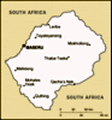
Location: Southern Africa, an enclave of South Africa
Geographic coordinates: 29 30 S, 28 30 E
Map references: Africa
Area: Total: 30,355 sq km land: 30,355 sq km water: 0 sq km
Area - comparative: Slightly smaller than Maryland
Land boundaries: Total: 909 km border countries: South Africa 909 km
Coastline: 0 km (landlocked)
Maritime claims: None (landlocked)
Climate: Temperate; cool to cold, dry winters; hot, wet summers
Terrain: Mostly highland with plateaus, hills, and mountains
Elevation extremes: Lowest point: junction of the Orange and Makhaleng Rivers 1,400 m highest point: Thabana Ntlenyana 3,482 m
Natural resources: Water, agricultural and grazing land, diamonds, sand, clay, building stone
Land use: Arable land: 10.87% permanent crops: 0.13% other: 89% (2001)
Irrigated land: 10 sq km (1998 est.)
Natural hazards: Periodic droughts
Environment - current issues: Population pressure forcing settlement in marginal areas results in overgrazing, severe soil erosion, and soil exhaustion; desertification; Highlands Water Project controls, stores, and redirects water to South Africa
Environment - international agreements: Party to: Biodiversity, Climate Change, Climate Change-Kyoto Protocol, Desertification, Endangered Species, Hazardous Wastes, Marine Life Conservation, Ozone Layer Protection signed, but not ratified: Law of the Sea
Geography - note: Landlocked, completely surrounded by South Africa; mountainous, more than 80% of the country is 1,800 meters above sea level
Advertisement
The information here has been derived from Public Domain Sources such as the CIA World Factbook. No liability can be taken for any inaccuracies.
Tot: 0.018s; Tpl: 0.007s; cc: 3; qc: 2; dbt: 0.0017s; 1; m:domysql w:travelblog (10.17.0.13); sld: 1;
; mem: 1.1mb
 Basutoland was renamed the Kingdom of Lesotho upon independence from the UK in 1966. King MOSHOESHOE was exiled in 1990, but returned to Lesotho in 1992 and reinstated in 1995. Constitutional government was restored in 1993 after 23 years of military...