Maltese Geography, Malta Geography
Advertisement
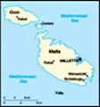
Location: Southern Europe, islands in the Mediterranean Sea, south of Sicily (Italy)
Geographic coordinates: 35 50 N, 14 35 E
Map references: Europe
Area: Total: 316 sq km land: 316 sq km water: 0 sq km
Area - comparative: Slightly less than twice the size of Washington, DC
Land boundaries: 0 km
Coastline: 196.8 km (does not include 56.01 km for the island of Gozo)
Maritime claims: Territorial sea: 12 nm contiguous zone: 24 nm continental shelf: 200-m depth or to the depth of exploitation exclusive fishing zone: 25 nm
Climate: Mediterranean with mild, rainy winters and hot, dry summers
Terrain: Mostly low, rocky, flat to dissected plains; many coastal cliffs
Elevation extremes: Lowest point: Mediterranean Sea 0 m highest point: Ta'Dmejrek 253 m (near Dingli)
Natural resources: Limestone, salt, arable land
Land use: Arable land: 28.13% permanent crops: 3.13% other: 68.74% (2001)
Irrigated land: 20 sq km (1998 est.)
Natural hazards: NA
Environment - current issues: Very limited natural fresh water resources; increasing reliance on desalination
Environment - international agreements: Party to: Air Pollution, Biodiversity, Climate Change, Climate Change-Kyoto Protocol, Desertification, Endangered Species, Hazardous Wastes, Law of the Sea, Marine Dumping, Ozone Layer Protection, Ship Pollution, Wetlands signed, but not ratified: none of the selected agreements
Geography - note: The country comprises an archipelago, with only the three largest islands (Malta, Ghawdex or Gozo, and Kemmuna or Comino) being inhabited; numerous bays provide good harbors; Malta and Tunisia are discussing the commercial exploitation of the continental shelf between their countries, particularly for oil exploration
Advertisement
The information here has been derived from Public Domain Sources such as the CIA World Factbook. No liability can be taken for any inaccuracies.
Tot: 0.02s; Tpl: 0.008s; cc: 3; qc: 2; dbt: 0.0021s; 1; m:domysql w:travelblog (10.17.0.13); sld: 1;
; mem: 1.1mb
 Great Britain formally acquired possession of Malta in 1814. The island staunchly supported the UK through both World Wars and remained in the Commonwealth when it became independent in 1964. A decade later Malta became a republic. Since about the mi...