Estonian Geography, Estonia Geography
Advertisement
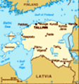
Location: Eastern Europe, bordering the Baltic Sea and Gulf of Finland, between Latvia and Russia
Geographic coordinates: 59 00 N, 26 00 E
Map references: Europe
Area: Total: 45,226 sq km land: 43,211 sq km water: 2,015 sq km note: includes 1,520 islands in the Baltic Sea
Area - comparative: Slightly smaller than New Hampshire and Vermont combined
Land boundaries: Total: 633 km border countries: Latvia 339 km, Russia 294 km
Coastline: 3,794 km
Maritime claims: Territorial sea: 12 nm exclusive economic zone: limits fixed in coordination with neighboring states
Climate: Maritime, wet, moderate winters, cool summers
Terrain: Marshy, lowlands; flat in the north, hilly in the south
Elevation extremes: Lowest point: Baltic Sea 0 m highest point: Suur Munamagi 318 m
Natural resources: Oil shale, peat, phosphorite, clay, limestone, sand, dolomite, arable land, sea mud
Land use: Arable land: 16.04% permanent crops: 0.45% other: 83.51% (2001)
Irrigated land: 40 sq km (1998 est.)
Natural hazards: Sometimes flooding occurs in the spring
Environment - current issues: Air polluted with sulfur dioxide from oil-shale burning power plants in northeast; however, the amount of pollutants emitted to the air have fallen steadily, the emissions of 2000 were 80% less than in 1980; the amount of unpurified wastewater discharged to water bodies in 2000 was one twentieth the level of 1980; in connection with the start-up of new water purification plants, the pollution load of wastewater decreased; Estonia has more than 1,400 natural and manmade lakes, the smaller of which in agricultural areas need to be monitored; coastal seawater is polluted in certain locations
Environment - international agreements: Party to: Air Pollution, Air Pollution-Nitrogen Oxides, Air Pollution-Sulfur 85, Air Pollution-Volatile Organic Compounds, Antarctic Treaty, Biodiversity, Climate Change, Climate Change-Kyoto Protocol, Endangered Species, Hazardous Wastes, Ship Pollution, Ozone Layer Protection, Wetlands signed, but not ratified: none of the selected agreements
Geography - note: The mainland terrain is flat, boggy, and partly wooded; offshore lie more than 1,500 islands
Advertisement
The information here has been derived from Public Domain Sources such as the CIA World Factbook. No liability can be taken for any inaccuracies.
Tot: 0.054s; Tpl: 0.008s; cc: 3; qc: 8; dbt: 0.0071s; 1; m:domysql w:travelblog (10.17.0.13); sld: 1;
; mem: 1.1mb
 After centuries of Danish, Swedish, German, and Russian rule, Estonia attained independence in 1918. Forcibly incorporated into the USSR in 1940, it regained its freedom in 1991, with the collapse of the Soviet Union. Since the last Russian troops le...