Channel Islander Geography, Jersey Geography
Advertisement
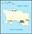
Location: Western Europe, island in the English Channel, northwest of France
Geographic coordinates: 49 15 N, 2 10 W
Map references: Europe
Area: Total: 116 sq km land: 116 sq km water: 0 sq km
Area - comparative: About two-thirds the size of Washington, DC
Land boundaries: 0 km
Coastline: 70 km
Maritime claims: Territorial sea: 3 nm exclusive fishing zone: 12 nm
Climate: Temperate; mild winters and cool summers
Terrain: Gently rolling plain with low, rugged hills along north coast
Elevation extremes: Lowest point: Atlantic Ocean 0 m highest point: unnamed location 143 m
Natural resources: Arable land
Land use: Arable land: 0% permanent crops: 0% other: 100% (2001)
Irrigated land: NA sq km
Natural hazards: NA
Environment - current issues: NA
Environment - international agreements:
Geography - note: Largest and southernmost of Channel Islands; about 30% of population concentrated in Saint Helier
Advertisement
The information here has been derived from Public Domain Sources such as the CIA World Factbook. No liability can be taken for any inaccuracies.
Tot: 0.033s; Tpl: 0.007s; cc: 3; qc: 10; dbt: 0.0099s; 1; m:domysql w:travelblog (10.17.0.13); sld: 1;
; mem: 1.1mb
 The island of Jersey and the other Channel Islands represent the last remnants of the medieval Dukedom of Normandy that held sway in both France and England. These islands were the only British soil occupied by German troops in World War II....