Barbadian or Bajan (colloquial) Geography, Barbados Geography
Advertisement
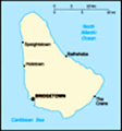
Location: Caribbean, island in the North Atlantic Ocean, northeast of Venezuela
Geographic coordinates: 13 10 N, 59 32 W
Map references: Central America and the Caribbean
Area: Total: 431 sq km land: 431 sq km water: 0 sq km
Area - comparative: 2.5 times the size of Washington, DC
Land boundaries: 0 km
Coastline: 97 km
Maritime claims: Territorial sea: 12 nm exclusive economic zone: 200 nm
Climate: Tropical; rainy season (June to October)
Terrain: Relatively flat; rises gently to central highland region
Elevation extremes: Lowest point: Atlantic Ocean 0 m highest point: Mount Hillaby 336 m
Natural resources: Petroleum, fish, natural gas
Land use: Arable land: 37.21% permanent crops: 2.33% other: 60.46% (2001)
Irrigated land: 10 sq km (1998 est.)
Natural hazards: Infrequent hurricanes; periodic landslides
Environment - current issues: Pollution of coastal waters from waste disposal by ships; soil erosion; illegal solid waste disposal threatens contamination of aquifers
Environment - international agreements: Party to: Biodiversity, Climate Change, Climate Change-Kyoto Protocol, Desertification, Endangered Species, Hazardous Wastes, Law of the Sea, Marine Dumping, Ozone Layer Protection, Ship Pollution signed, but not ratified: none of the selected agreements
Geography - note: Easternmost Caribbean island
Advertisement
The information here has been derived from Public Domain Sources such as the CIA World Factbook. No liability can be taken for any inaccuracies.
Tot: 0.027s; Tpl: 0.008s; cc: 3; qc: 2; dbt: 0.0052s; 1; m:domysql w:travelblog (10.17.0.13); sld: 1;
; mem: 1.1mb
 The island was uninhabited when first settled by the British in 1627. Slaves worked the sugar plantations established on the island until 1834 when slavery was abolished. The economy remained heavily dependent on sugar, rum, and molasses production t...