Sao Tomean Geography, Sao Tome and Principe Geography
Advertisement
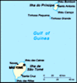
Location: Western Africa, islands in the Gulf of Guinea, straddling the Equator, west of Gabon
Geographic coordinates: 1 00 N, 7 00 E
Map references: Africa
Area: Total: 1,001 sq km land: 1,001 sq km water: 0 sq km
Area - comparative: More than five times the size of Washington, DC
Land boundaries: 0 km
Coastline: 209 km
Maritime claims: Measured from claimed archipelagic baselines territorial sea: 12 nm exclusive economic zone: 200 nm
Climate: Tropical; hot, humid; one rainy season (October to May)
Terrain: Volcanic, mountainous
Elevation extremes: Lowest point: Atlantic Ocean 0 m highest point: Pico de Sao Tome 2,024 m
Natural resources: Fish, hydropower
Land use: Arable land: 6.25% permanent crops: 48.96% other: 44.79% (2001)
Irrigated land: 100 sq km (1998 est.)
Natural hazards: NA
Environment - current issues: Deforestation; soil erosion and exhaustion
Environment - international agreements: Party to: Biodiversity, Climate Change, Desertification, Endangered Species, Environmental Modification, Law of the Sea, Ozone Layer Protection, Ship Pollution signed, but not ratified: none of the selected agreements
Geography - note: The smallest country in Africa; the two main islands form part of a chain of extinct volcanoes and both are fairly mountainous
Advertisement
The information here has been derived from Public Domain Sources such as the CIA World Factbook. No liability can be taken for any inaccuracies.
Tot: 0.021s; Tpl: 0.01s; cc: 3; qc: 2; dbt: 0.0016s; 1; m:domysql w:travelblog (10.17.0.13); sld: 1;
; mem: 1.1mb
 Discovered and claimed by Portugal in the late 15th century, the islands' sugar-based economy gave way to coffee and cocoa in the 19th century - all grown with plantation slave labor, a form of which lingered into the 20th century. Although independe...