Dominican Geography, Dominica Geography
Advertisement
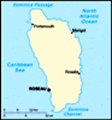
Location: Caribbean, island between the Caribbean Sea and the North Atlantic Ocean, about one-half of the way from Puerto Rico to Trinidad and Tobago
Geographic coordinates: 15 25 N, 61 20 W
Map references: Central America and the Caribbean
Area: Total: 754 sq km land: 754 sq km water: 0 sq km
Area - comparative: Slightly more than four times the size of Washington, DC
Land boundaries: 0 km
Coastline: 148 km
Maritime claims: Territorial sea: 12 nm contiguous zone: 24 nm exclusive economic zone: 200 nm
Climate: Tropical; moderated by northeast trade winds; heavy rainfall
Terrain: Rugged mountains of volcanic origin
Elevation extremes: Lowest point: Caribbean Sea 0 m highest point: Morne Diablatins 1,447 m
Natural resources: Timber, hydropower, arable land
Land use: Arable land: 6.67% permanent crops: 20% other: 73.33% (2001)
Irrigated land: NA sq km
Natural hazards: Flash floods are a constant threat; destructive hurricanes can be expected during the late summer months
Environment - current issues: NA
Environment - international agreements: Party to: Biodiversity, Climate Change, Climate Change-Kyoto Protocol, Desertification, Endangered Species, Environmental Modification, Hazardous Wastes, Law of the Sea, Ozone Layer Protection, Ship Pollution, Whaling signed, but not ratified: none of the selected agreements
Geography - note: Known as "The Nature Island of the Caribbean" due to its spectacular, lush, and varied flora and fauna, which are protected by an extensive natural park system; the most mountainous of the Lesser Antilles, its volcanic peaks are cones of lava craters and include Boiling Lake, the second-largest, thermally active lake in the world
Advertisement
The information here has been derived from Public Domain Sources such as the CIA World Factbook. No liability can be taken for any inaccuracies.
Tot: 0.018s; Tpl: 0.007s; cc: 3; qc: 2; dbt: 0.0021s; 1; m:domysql w:travelblog (10.17.0.13); sld: 1;
; mem: 1.1mb
 Dominica was the last of the Caribbean islands to be colonized by Europeans, due chiefly to the fierce resistance of the native Caribs. France ceded possession to Great Britain in 1763, which made the island a colony in 1805. In 1980, two years after...