Advertisement
Published: March 31st 2014

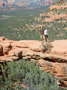
 Devil's Bridge
Mark and I on top of the Arch at the end of a steep trail. This will be the last blog for our winter trip this year. It has been a another great adventure that started near the ocean at Gulf Shores State Park in Alabama and is ending at one of our favorite parks in the high desert of Arizona , Dead Horse Ranch State Park in Cottonwood. The name of this park has a story that goes back to the 1940's when the Ireys family was looking for ranch property to buy. After many days of seeing different properties Mr. Ireys asked the family which property did they think was best. The kids said the one with the dead horse, and the name stuck. In 1973 Arizona State Parks acquired the property on the condition that the name stay the same.
Our stay at Dead Horse was made even better when Mark came to visit. He is not one to sit still for long and we did a lot of hiking together and explored new areas and revisited some of our favorites. I'll let the pictures tell you about the places we visited. Ron and Mark did take a day to rent ATV's and drive around the

 Red Rock State Park, Arizona
At the top of Eagle's nest trailbeautiful red rock area of Sedona. They had a great time off roading even when a dust devil caught them by surprise and they were pelleted by the sand and rocks it was carrying in its rotation. Mark also saw his first dust storm and said he could check that off his bucket list. We were so glad to spend time with him.
We are heading home ourselves now and Kris has turn on the water and the heat at the house. Ed has shoveled away the last of the snow drifts so we can use the sidewalk. Kris did send us a picture of the still solidily frozen lake - it will be nice to watch it thaw this year.
Click on Pictures to enlarge - there are 15 total
Advertisement
Tot: 0.098s; Tpl: 0.011s; cc: 13; qc: 64; dbt: 0.0597s; 1; m:domysql w:travelblog (10.17.0.13); sld: 1;
; mem: 1.1mb

 Devil's Bridge
 Red Rock State Park, Arizona


Timothy Dobry
non-member comment
Welcome
Thank you both very much and welcome home. TD-AMNWD