The Annapurna Circuit


Advertisement
Nepal's flag
Asia » Nepal » Annapurna » Annapurna Circuit
June 2nd 2010
Published: June 2nd 2010
Edit Blog Post

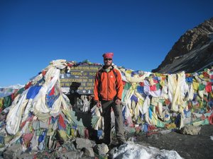
I made it!I made it!I made it!

I reach Thorung La (5416m/17,800feet) just before 8 in the morning. It is a clear and sunny day. Despite the altitude it feels warm because of the piercingly strong sun.
The Nepali view the Trans-Himalaya, the high altitude passes and valleys of the world's highest mountain range, with a great deal of reverence. Here the sun will burn exposed flesh within a few minutes, the wind can gust over 100 mph in the afternoons, and snowstorms can appear out of thin air. Someone flown in from sea level to a place like Thorung La (5416 M, 17800 feet) would die from lack of oxygen within 24 hours. It is one of the world's toughest environments for people to visit, but also one of the most beautiful.

I spent the last 21 days hiking the Annapurna Circuit and Base Camp treks in the Annapurna region of Nepal. In three weeks I covered over 200 miles of terrain ranging from low valleys similar in climate to Florida to the high altitude Thorung La pass where snow is present year round. I took a side trip to the stunningly beautiful Tilicho Lake at 4920 m/16,120 feet, and hiked into the Annapurna Sancturary before returning to Pokhara. Over the past three weeks I have had an enormously wide range of experiences ranging from watching the sunrise perched on a slope 3 miles high, to getting stuck in a freak snowstorm high up on a ridge, to seeing a sheep sacrificed at a festival to appease a local spirit.

I try to make an effort to avoid cliched writing in this blog, so I will let the photos speak for themselves and refrain from describing this trek as the "experience of a lifetime" or the "most beautiful place ever". I will post a brief photo-journal outline of my trip here on this site. Anyone interested in seeing more photos of this region can check my facebook page where I will post a wider selection of pictures. I want these pictures to be accessible to the general public, so I will post a link to the facebook albums here on this site within the next couple days.

Thank you


Additional photos below
Photos: 98, Displayed: 23


Advertisement

Bhulbhule Check PostBhulbhule Check Post
Bhulbhule Check Post

The real start of the hike. Actually I got of the bus and started hiking a few kilometers early, because the ride was frustratingly slow. But this is the official trailhead at 790 M/2500 feet.
FlowersFlowers
Flowers

The Annapurna region is located at the same latitude as Orlando, Florida. The first two days were spent at lower elevations where lush flowers and plants grow.
Marsyangdi RiverMarsyangdi River
Marsyangdi River

The Annapurna Circuit follows two river valleys. I hiked up along the Marsyangdi river, over Thorung La pass, and down the Kali Gandaki river valley. Because most of the hike follows the valley floor, the terrain is relatively easy, and the climb up to higher altitudes is long but not steep.
View - Day 1 View - Day 1
View - Day 1

A rare glimpse of some of the distant higher peaks on the first day. It's not until day 3 that the main Annapurna ridge line becomes clearly visible.
View from TeahouseView from Teahouse
View from Teahouse

May is shoulder season on the Circuit, because the monsoon has already begun in some of the lower valleys. My first day on the circuit was a short one due to a late start and afternoon thunderstorms. In the low lying subtropical zone mornings were generally clear, middays hot and humid, and late afternoons rainy.
Marsyangdi River ValleyMarsyangdi River Valley
Marsyangdi River Valley

The 2nd day of the trek I sat here and ate breakfast.
Suspension BridgeSuspension Bridge
Suspension Bridge

Because the Annapurna Circuit is a major trade route, there are good bridges over river crossings and gorges. Next to this bridge is a banana tree, common in the lower elevations.
Ghermu - 1100M/3500 FtGhermu - 1100M/3500 Ft
Ghermu - 1100M/3500 Ft

One of many low altitude villages I passed through. The lower altitudes were heavily settled and farmed, while the higher altitudes were stark and barren.
Terraced FarmingTerraced Farming
Terraced Farming

In the subtropical zone, crops are grown on terraces built into the hillside. While I was hiking corn was being harvested and rice was being planted.
Up the valleyUp the valley
Up the valley

The 2nd day was a tough one, spent hiking up out of the steamy subtropical valleys.
It's called weed for a reasonIt's called weed for a reason
It's called weed for a reason

Cannabis grows wild between 1000 and 2000 meters in elevation throughout the Himalaya
WaterfallWaterfall
Waterfall

One of many many waterfalls I passed on the hike. This one was over 200 meters high - double the height of Niagara Falls.
Day 3Day 3
Day 3

I stayed the second night in village of Tal at 1700 M/5500 feet. Tal was located at the boundary of the hotter subtropical zone, and the cooler higher temperate zone. On the third day the scenery, flora, and fauna changed dramatically as I crossed into the temperate zone.
Temperate ZoneTemperate Zone
Temperate Zone

The temperate zone was defined by conifers, ferns, flowering plants, cooler temperatures, and clearer skies.
looking back down the valley. looking back down the valley.
looking back down the valley.

On day 3 I hiked from Tal at 1700/5500 up to Chame at 2700m/9000 feet. The day was clear and the views amazing all day long.
DanaqueDanaque
Danaque

Village of Danaque or Danakyu at 2300 m/7500.
Conifer forestConifer forest
Conifer forest

The second half of the day was spent in old growth pine forest.


10th June 2010

wow
hey!! great pictures! how is the trekking going? and when are you going to come visit?

Tot: 0.056s; Tpl: 0.015s; cc: 8; qc: 24; dbt: 0.0292s; 1; m:domysql w:travelblog (10.17.0.13); sld: 1; ; mem: 1mb