Advertisement
Published: June 24th 2009

 PapaD
PapaD
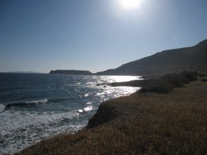
The coastline at Papadiokambos-- one of the project's goals is to learn more about how sea-based trade would have worked on site.In rather characteristic fashion, this week started off slow (sensing a pattern here?). Last Monday I was slated to help Kroni, the Center's professional photographer, take pictures of the Minoan site of Petras (Pe-trahs). Petras is a major Bronze Age site, with evidence for human occupation from the Neolithic through Late Bronze Age-- and it features a Late Bronze Age administrative complex, as well as a number of caves and rock shelters that are believed to have been used as ceremonial or ritual sites. But, it was the Minoan and Late Bronze Age graveyard that had been excavated this season, and which we were supposed to photograph. Unfortunately, because the winds had picked up for the day, we were unable to. (See the photo from my last blog entry which shows the 5 meter boom-arm that we mount the camera on to take photos from a birds-eye view...with winds whipping around, Kroni wasn't keen on putting his $1000 camera 15 feet off the ground...). That meant that I was able to spend some time having a coffee and buying a pair of jeans (for my spelunking expedition...see below) in Sitia, which is the small city located half a kilometer from Petras.

 GPRing
Yours truly dragging the GPR on one of the many survey lines we did. The GPR is basically a big-box antenna which sends low frequency radio waves into the ground, and by reading the returning waves can help pinpoint possible architecture.It also meant that I was free for the afternoon-- a two hour time period that I spent catching some Z's after our long, eventful weekend in Heraklion.
On Tuesday it was back to the GPR, when Antonia and I (helped by two other students from other excavations) went out to the site of Papadiokambos to survey three areas. PapaD (featured in my last post-- since I spent a day last week clearing the survey areas of ground cover and rocks) will be excavated by Tom Brogan (the director at INSTAP) and his team towards the end of the summer, and he is hoping that the GPR data will allow him to further pinpoint his excavations. We spent most of Tuesday surveying a particularly difficult area on the site, and then planned to finish the other two, smaller areas the following day. However, when we set up on Wednesday morning, we realized that the survey wheel (which the radar unit uses as a mechanism to time the sending of the radar signals) wasn't attaching to the unit's antenna properly. This meant that the equipment was unable to appropriately space-out the survey. We later learned that the connections in the wire

 Home Sweet Home...
My room at the Golden Beach Hotel, which was home for 3 weeks--that attached the survey wheel to the antenna had come loose and needed to be re-soddered. Antonia and the team were able to fix it later that afternoon and finished the survey on Thursday afternoon without much difficulty. I, however, checked out of my hotel on Wednesday afternoon, jumped in my newly rented car, and headed off to Kato Gouves (Kat-O Goo-vez) where I would be joining the Skoteino (Sko-ti-no) Cave project.
Skoteino Cave is located about 20 km from Heraklion (the capital of Crete), and about an hour and a half drive from Pacheia Amos where I had been staying for the past three weeks. The project has spent the past four years studying and mapping a large cave (about 200 m long and 70-85 m deep) that seems to have been used as a ritual location in the Neolithic period and the Bronze Age. The goals of the project for this year were to use a "Cloud-Scanner" to map the entire cave in 3D-- the cave had been "mapped" in a topographic way using another piece of surveying equipment called a "Total Station," last year and the year before, but this equipment promised to provide a different (and

 Spelunking
Posing amongst the stalactites, in the deepest, darkest part of the cave...my camera's got a pretty good flash, huh? much cooler) type of map. The scanner uses lasers (that reflect off the walls of the cave or other object, like walls, buildings, bridges, etc. and return to be read by the scanner) to measure the distance from the scanner, and elevation in order to locate those measurements as pixels on a 3D plane in the computer. That way we are able to create a 3D model which is accurate to about half a centimeter. By using 5 cm reflectors that we placed at various locations throughout the cave as reference points, the computer software is able to match and overlap the 40 or so scans that we took and create an entire 3D computer generated map of the cave. Then, by overlaying digital photos (taken by a digital camera on top of the scanner) onto these pixel points, the model can be given the appropriate coloring. This not only provides archaeologists with the unique ability of seeing the cave (or archaeological site) from any perspective (for example on from the top of a 15 foot stalagmite or from a birds-eye view), but it is also a tremendous tool for teaching and lectures, since this data makes it possible to

 The Cave has eyes...
This picture comes closest to capturing the blackness of the cave-- and the many white spots in the background are the reflectors we placed around so that the computer can tie the laser scans together.do a digital "fly through" of the cave or archaeological site-- in essence giving a virtual reality tour. It is an expensive piece of equipment (running anywhere from $100,000-$300,000 depending on the features and the size of the equipment-- smaller, lighter, but equally powerful laser scanners are more expensive than larger, clunkier models), but the team at Skoteino rented one for about $4,000 for four days.
So, on Thursday, Friday, Saturday and Sunday, John ( an assistant professor from Michigan State University, and the real "mind behind the scanner"), Antoni (pronounced An-do-ni, a Greek local from Heraklion who is a member of the local caving club), and I dragged the laser scanner, tripod, digital camera, and laptop up and down the cave, mapping about 95% of the total area (except for the most remote nooks and crannies). By the time we were done (working about 12 hour days, from 8AM to 8PM nearly every day), the laser scanner had taken more than 16 million points, and John had enough data to create a 3D model of the cave.
For my part, this was one of the strangest, and coolest projects I've worked on. The "Cloud Scanner" is a tremendously powerful

 A lesson in patience from Mother Nature
These stalactites have taken more than a million years to form-- talk about a lesson in patience and perseverance. The beauty of the cave, even in the darkest parts, was evident by flashlight.tool and strikes me as a one of the most important and versatile new and exciting tools for archaeologists (despite the price tag)-- especially as something that can make archaeological sites more accessable to other members of the archaeological community, and, more importantly, to the general public.--To piggy back on an earlier post, I couldn't help but imagine how much damage could have been prevented at Knossos has Sir Arthur Evans been able to use of these laser scanners, in order to create an ephemeral, digital mock up, instead of a permanent, concrete one-- I also really enjoyed spending so much time in the cave. While it was difficult to drag the equipment up and down the narrow passageways, it also was a very unique experience-- I feel like the time I spent down in the cave over those four days really made me appreciate the spectacular nature of the site, and why it would have been such a potent religious shrine in ancient times. What is more, I experienced real "darkness" for the first time. In the deepest and darkest parts of the cave on Thursday, where no light from the surface filters in, we worked by headlamp and

 Journeying to the Center of the Earth...
This picture really captures the size of the cave-- when I took this picture I was standing at level one looking back at the mouth of the cave, and there are five, progressively darker, levels going further down.flashlight only. But, as we were waiting for the laser scanner to do one of its scans (each of which took between 8 and 10 minutes depending on the resolution), Antoni, John and I decided to turn off all our lights, and as John closed the laptop that he used to control the scanner, we were plunged into the most tangible blackness I have ever felt. "Felt" is a much more appropriate description than "seen" since this sort of darkness is a total body experience-- for a minute I thought I could actually reach out and ball-up a chunk of this thick, utter blackness like a snowball. It was one of the more surreal feelings that I have had, and sitting there in the cave I realized that complete darkness is something that is a very rare thing to experience-- there are few places that one could go in this world and get away from light all together (light creeps in under doorways, through cracks, and around curtains-- even on the darkest night the stars provide some light). Strangely enough, I found myself feeling calm and relaxed, marveling at the experience, not nervous, frightened or panic stricken.
After working right

 $100,000 for an aluminum cylinder?!
John (foreground) and Antoni (background) prepare to take a scan of level 4- while I document the process, careful not to get in the way of the laser and botch the scan. down to the wire (John had to catch a ferry back to Athens at 9PM on Sunday...we worked until about 7:45 PM), I spent Sunday night and Monday morning debriefing with Loeta Tyree, the director of the project, and Floyd McCoy, a journey-man geologist from the University of Hawaii who's path I have crossed a number of times as he has been the geological consultant on many (if not all) of the projects I have helped with. Loeta, Floyd and John are working on a series of academic journal articles which will feature the cave and its ritual nature, but also one or two which will consider the pros and cons of different mapping techniques, including (especially) the laser scanner. By Monday at noon I was in my car headed to Mochlos to begin three (or four, if I end up changing my airplane ticket) weeks or excavation--- but an explanation of the work at Mochlos will have to wait until next week...
As always, I hope this post finds you all well, and that after four posts, you as still enjoying reading along. I'm sorry it has taken me a little longer to get this post up-- working

 Herbie and Me
My Hyundai Getz may be small, but Herbie gets the job done. The freedom of having a car (and not being reliant on bus schedules to travel around) is almost like being 17 again and not having to rely on Mom and Dad to get around...through the weekend really took up time I had planned on using to write-- anyway I'll post again this weekend with an explanation about Mochlos, and what I'm up to here. It's hard to believe that I've been in Crete for almost four weeks now- it's been a wonderful experience- and one that I have really been blessed to be a part of.
Until next week--
Take care,
Jeff
Advertisement
Tot: 0.071s; Tpl: 0.012s; cc: 5; qc: 44; dbt: 0.0466s; 1; m:domysql w:travelblog (10.17.0.13); sld: 1;
; mem: 1.2mb


Jud
non-member comment
LIDAR!
LIDAR is awesome, I'm surprised you had to pay that much for it though. I'm surprised it doesn't find its way into more above ground applications as well.