Advertisement
Published: February 26th 2008

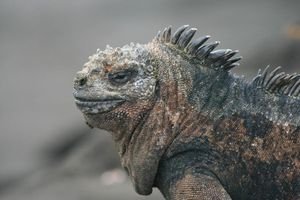
 Marine Iguana
Puerto Egas, Santiago Island, GalapagosFebruary 19
After our morning on Fernandina Island, we crossed the straight to Isabela Island and Tagus Cove. Tagus Cove is an old crater that acts as a nice harbour away from the open ocean. It was obvious that it was a stopping point for boats for a long time as there was a lot of graffiti painted on the rocks around the steep banks of the cove. Most of it was the names of people and boats that had visited there. The park takes an interesting view of this - the older stuff is seen as being a historical record of past adventurers. Apparently the oldest markings go back to shortly after Darwin made his famous journey. The newer stuff is simply vandalism. The dividing line seems to be about the time that the area was declared a national park in the 1970’s.
I began to sense that we were running out of things to see. If would be difficult to surpass what we had seen that morning on Fernandina. We had an interesting dry landing at Tagus Cove. As I mentioned, the walls of the cove were very steep, and the ocean swelled in cycles along the

 Tagus Cove
Isabela Island, Galapagosshore, raising and falling about 4 feet every minute or so. The panga would have to hang around close to shore and time a landing with the crest of a swell, then it would be a race to see how many people we could get on shore before the water started to drop again and the panga would back off. The panga would only hold 8 people plus crew, so our group of 16 always had to go ashore in two shifts. It was a fun landing as it had an added twist; we all had a good laugh while each landing was attempted, and people scrambled off.
After we had all made it ashore, we followed a trail on a climb up to a viewpoint. About a 100 feet above sea level, and in shore a bit, was another crater lake. Despite being 100 feet above sea level, the water in the crater is salty. Apparently this is one of the mysteries of the Galapagos. We continued our walk up to a viewpoint where we could see the eastern shoreline of Isabela.
After our return to the shoreline, we had the reverse of our landing, where we

 Darwin Crater
Tagus Cove, Isabela Island, Galapagoshad to scramble onboard the panga timed to the cresting ocean. From the Floreana, we then got organized for a snorkelling expedition into the bay. We got our gear on and piled into the panga which took us closer to shore. We jumped in and started exploring the steep banks of the crater as it dropped into the ocean. As we swam along, we came across a bit of a cave slightly above the water line that was filled with penguins. This was great to see, but again, no camera to record the event. I think if I continue with snorkel adventures I will have to get a camera with a good waterproof housing. Anyway, while we were in the water I was starting to feel uncomfortable; something was irritating my skin. Looking around underwater, I could see very fine, stringy looking things that turned out to be some kind of jellyfish, and they were stinging! The panga was following us as we swam, so I made a direct line heading towards it and pulled myself in. I then realized that everyone else had the same problem and idea, and the panga was full and heading back to the boat

 East coast of Isabela
From viewpoint above Tagus Cove
Isabela Island, Galapagossoon afterwards. My skin had lines of red rash across some of the tender spots like on the bottom of my arms. I showered as soon as I got back to the boat. The rash disappeared by the next day. The crew called this “agua mala” or sick water; I guess it was not uncommon in some places.
After we were back on board, the boat got under way as we had an all-night cruise ahead of us. We had to go around the top of Isabela, and then over to the northwest side of Santiago. Over the night, we crossed the equator twice, northbound on the west of Isabela, and southbound on the east.
February 20
We arrived at Puerto Egas on the northwest side of Santiago Island at about 3 AM, I awoke briefly as the anchor was being set. We had been underway for about 10 hours.
Puerto Egas was once the site of a salt mine, up until about 1970 when the cost of shipping the salt to the mainland grew too expensive. The site was abandoned, and all that remains are the walls of an old building, and some floor slabs where

 Remnants of volcanic activity
Tagus Cove, Isabela Island, Galapagosbuildings once stood. There was an old road that went up into the hills to an old crater, where the water had a very high salinity. This is where they got the salt.
The bay was crowded with tour boats, about 6 at one point, the most we had seen in one place. We were getting closer to civilization, and only a few hours travel time from the main island. They all landed their guests in the morning, as did we. We slowly worked our way alone the shoreline trail, waiting for the group ahead of us to move on before we did. We saw more sea lions and marine iguanas. There was an interesting mix of lava and ash sediment visible along the cliffs around the bay. You could see the many layers of ash from eruptions over the eons. At various places along the trail you could either be walking on a sedimentary-looking surface that was hardened ash, or lava flows. After our walk around the trail, we were back at the beach with the intent on going snorkelling. There were so many people on the beach and in the water that I decided, along with most

 Marine Iguana
Puerto Egas, Santiago Island, Galapagosothers of our tour, just to head back to the boat.
In the afternoon, most of the morning tour boats had left, and we went ashore to walk up to the crater that was once the salt mine. It was a 3 km hike to the crater, a gradual uphill climb for most of the way. The trail was not well used, so it was obvious that not many tours could be bothered to make the trek. On our return, a number of new boats had arrived.
This was our final night of the tour, and a special meal was prepared for us, along with a birthday cake for one of the guests. We had a drink before dinner and toasted the captain and crew for a great week. The captain sat at our table after supper and we had a great conversation about the wildlife we saw, and what other wildlife could be seen at the other islands we didn’t visit. We talked about the outside world’s conception of the Galapagos, and how the media influences it, usually with only bad news. We talked for over an hour, and I impressed myself with how well my Spanish

 Big Crab
Puerto Egas, Santiago Island, Galapagoswas holding up.
Afterwards, the boat got underway, and we moved to the sundeck on top of the boat. Then something unexpected and wonderful happened: A full lunar eclipse was under way, and we got to watch it from the darkness of a boat on the open ocean. I moved to the deck at the front of the boat and lied down and watched the moon as it was eclipsed, then the stars with the moon obscured. I saw the Orion constellation actually a little to the north of me, directly overhead. From Alberta, Orion is usually just above the southern horizon.
We cruised to Rabida Island (about 2.5 hours from Puerto Egas) where we had been earlier in our tour, and anchored for the night.
Advertisement
Tot: 0.207s; Tpl: 0.011s; cc: 12; qc: 70; dbt: 0.1429s; 1; m:domysql w:travelblog (10.17.0.13); sld: 1;
; mem: 1.2mb


Mego
non-member comment
That crab looks delicious