Advertisement

 Clever tools
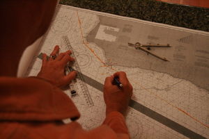
A pointy-compass thingy, a rolly-ruler gadget and a pencil. One of the most unexpected aspects of this journey is the absolute requirement that a specific degree of education be acquired. This isn't daysailing on a lake. This isn't dog-paddling in a pool. This isn't back-stroking through a puddle. THIS IS SAILING ON THE #@&*ING PACIFIC OCEAN.
The Pacific Ocean is a big place. If you can't see land, how do you know where you are? If you're like me, you ask Captain Harry sweetly, "Where are we, darling dearest Captain?" If you're like Harry, you point to the 184 charts (not an exaggeration) and say, "Figure it out, peachy-pookie."
So last night we had our second serious seminar on sailing, scintillating way-point plotting and all. Peter and I were given way-points, which are pre-determined (by Captain Harry) spots upon the planet that we hope to sail near to. A way-point looks like this: 44.37.55.2"N, 124.08.57.6W. Harry expected us to find these way-points on the paper charts, and mark them there. This way, as we're sailing the open seas and nowhere near land, we can take readings from the GPS, mark them on the chart and know exactly where we are and where we are in relationship to

 Clever tools II
The brain. Captain Harry plots.where we SHOULD be, based on the way-points.
We get out the big-ass charts and the pointy-compass thing and the rolly-ruler gadget and, if we're lucky, colored pencils because it's impossible to see regular pencil on the grayscale chart. Using these highly technical tools, plus our brains, we were able to plot our way through the charts! It was one of the most elegant and beautiful pieces of problem-solving I've ever seen. Peter got very fascinated by it and muttered a lot about bringing his own colored pencils on the trip, as he plotted point after point.
I have to say I appreciate Captain Harry arming both Peter and I with the skills to find ourselves. I've been just dying for this kind of explicit instruction.
Learning how to plot way-points on the chart gave me a good idea about what Harry loves so much about navigating. When you have your latitude and your longitude, you know where you are. It's profoundly reassuring. The process is crystalline in its simplicity. I'm surprised that I was ok with not knowing about this for so long. It's as if Harry had this fantastic secret and now I can't stop looking at him in awe.
Our house in Eugene is 44.03.85.3N, 123.06.14.2 W.
J
Advertisement
Tot: 0.131s; Tpl: 0.01s; cc: 9; qc: 48; dbt: 0.0475s; 1; m:domysql w:travelblog (10.17.0.13); sld: 1;
; mem: 1.1mb

 Clever tools
 Clever tools II
Daddio
non-member comment
I am sooo impressed
And to think all this time you only "thought" you knew where you were. And now you can see where you are to go and where you have been. Sounds almost spiritual in a way. Keep up the good work, Bon Voyage is not to far away. Joy, you were born to blog.