Advertisement
Published: March 23rd 2013

 Laguna 69
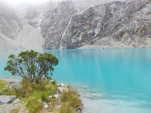
The azure waters that awaited us at the end of the hikeThe aim when leaving Cusco was to get up into the high mountains of the Cordillera Blanca for a few weeks of trekking en-route to Ecuador. This was achieved via a short flight, a long bus and a half day layover in the capital Lima. Half a day is not much to devote to a nation's capital, but it felt like it was probably all I really needed there!! I visited some pleasant parks – including an impressive one containing 14 different fountains all lit up at night – and got to see the sea for the first time on my trip, but that was enough for me!!
Huaraz is the gateway town to the high Andes in northern Peru and to my mind was another unremarkable town, with a remarkable setting: a high altitude valley settled amongst the peaks. My plan was to complete a longer multi-day trek, so as preparation I squeezed in three day-long walks. The first was to the main viewpoint above town, and when I found the path continued higher and higher into the hills, I just followed it. It was a walk remarkable for its isolation and also for the most vicious dogs yet

 Tunnel of Love - Lima
Although it didn't seem quite so "lovely" when some joker put his hand in one of the cascades ensuring everyone got soaked!encountered on the trip. It was the first time I had to pick up a rock to potentially defend myself, and thought I might have to use it!
With some friends from the hostel I also completed the trek to Laguna 69. It was a great walk, initially through the meadows, then up past two waterfalls and eventually emerging at the laguna, which is the most profound shade of azure and a great reward for the climb.
The next day my friend Laura and I decided to take public transport to attempt the Laguna Churup trail, and at about the 5
th attempt we found a bus going somewhere near the trailhead. “Somewhere near” was in fact about an hour and a half's uphill walk, but the hike was very pleasant so it was no issue.
For the walk up to Laguna Churup, Laura and I agreed to split up as she was not feeling very well and didn't expect to continue all the way up to the lake. I made good time stomping up solo, even though the final section was actually quite technical as there were ropes and wires installed to help you physically climb upwards

 Laguna Churup
Before the biblical rain and hailstones descendedto skirt around a waterfall created by the water flowing from the lake. I enjoyed my time up at the lake, although it certainly wasn't as impressive as Laguna 69.
I was surprised to meet Laura on the way back down, who had started feeling better and we probably crossed paths around 20 minutes from the summit. It had been a leisurely start to the day with a cracking breakfast, so all along we had agreed that 3p.m. would be our turn back time to make sure we didn't get into any difficulty.
Looking back we made the slightly foolish decision to push onwards back up to the summit, and I arrived there for the second time, but unfortunately after our turn back time. Predictably, at this point the heavens open and the rain was of biblical proportions, with a good measure of hail thrown in to really test our resolve!
After previous bad experiences when my frail body has given up the ghost on hikes in the cold and wet (earlier blogs are somewhat littered with these “learning experiences”!!), rather than plod on goldfish-like and make the same mistakes over and over, I had actually come

 A tricky descent...
...you can see the path working its way up to the rocks at the left of the waterfallfully prepared even though we had set off in glorious sunshine and a cloudless sky. My two set of waterproofs, two sets of gloves and multiple fleeces meant I was ready to battle the elements. However Laura – having had her waterproofs stolen just a couple of days earlier – was somewhat less prepared, so after dividing up my gear we took on the rope and wire descent down the side of the waterfall, which had been made even more difficult by the fact that there was now a river flowing down the path of least resistance at the side of the waterfall – the same route that the wires had been fixed to to assist us!!
It was a genuinely hairy descent, freezing cold and very tricky – but we took it slowly and made it down all of the climbs in one piece. After my freezing cold mountain bike ride in La Paz, I had invested a whole 10 bolivianos (£1!) in the finest new ear protecting hat that Bolivia could produce, which meant that this time only my fingers were causing me pain from the cold!!
We neared the base of the walk, fearing that

 Campsite with a view...
Night two on the Santa Cruz trekour public transport arrival would mean we had a lot more walking, coupled with a hefty dose of waiting by the roadside in the rain, to endure. However, by some miracle, there was a minibus waiting at the base of the trail and we gratefully agreed to the premium price the driver had quoted to get us back to Huaraz!
This journey proved that a Peruvian bus is never full, as with each village we passed, more and more locals managed to pile in. We even managed to pick up three mountain bikers caught in the storm with their bikes somehow being fixed on the roof!! At least all the extra bodies warmed the bus up – even if it wasn't that comfortable!
It was all good preparation for the four day Santa Cruz trek. I had originally planned to do the trek unsupported, carrying all my gear and food myself, hopefully rekindling great memories of when my friend James and I had spent 4 or 5 weeks trekking around Patagonia in the same manner in 2006. However, perhaps due to my lack of social skills, I couldn't find a “buddy” to do the trek with, and after

 Paso Union
Reaching the highest point on the trekthe chastening experience of hiking through the rain at Laguna Churup I decided that attempting a solo, unsupported trek over a 4,750 metre pass in the middle of the rainy season in the Peruvian Andes may not be the most sensible idea. When an agency quoted me just $120 for a trek where they would provide and set up all the tents, and provide and cook all the meals I was sold! (it was about the same as it would have cost to hire the necessary equipment and buy the food)
The first day we had a little “problemita” (teeny, tiny problem!!) as the guide called it. The muleteer couldn't find three of his mules (the way it was described made it sound quite comical – like he was tramping up hill and down dale searching in vain for his beasts of burden). The long and the short of it was we weren't going anyway that first day, so we'd have to make up the time on days 2 and 3!!
We spend the next day meandering upwards, following the valley cut by a river and through fields with wild horses grazing. Before we knew it we were

 Views of the beautiful Alpamayo valley
You can make out Alpamayo, although it is slightly covered in cloud.somehow up at our campsite at 4,400m and the day was drawing to a close. The spot couldn't be better, alongside a lake, surrounded by high mountains and in view of the high pass that we would cross the next morning.
Unfortunately, the early morning climb to the 4,750m Paso Union that marked the beginning of our most challenging and exciting day, was completely shrouded in fog. However, from the pass we were still offered tantalising glimpses down the next valley and also viewsof a turquoise lake reminiscent of Laguna 69.
The main highlight that makes this trek so popular are views of the 5,950m Alpamayo mountain, widely regarded as one of the most beautiful mountains in the world because its summit is almost a perfect pyramid. The side trip to the viewpoint was a lovely walk, and although the views were never completely free of cloud – considering it was rainy season I think we were reasonably lucky to have a view of it at all!
The final day was a Monday, and when started walking at around 7a.m. (about the time I used to leave the house sometimes for work) I remember thinking how the

 Alpamayo
The clouds did part on a few occasions!beautiful views back up the valley, with the sunlight reflecting from the river, and the mountains visible but shrouded in mist, was probably the best Monday morning view I'll have for a while! It had been an enjoyable – if reasonably easy trek – with the two tough, spectacular middle days sandwiched in between two very gentle days. Although, I know I'd never have described the trek as easy if I was doing it unsupported and lugging 25kg or so of equipment over a 4,750m pass!
There was a brief hiatus in the high altitude living, as a group of 6 of us from the trek headed to the coast for a couple of days at a town called Huanchaco. Here I was able to visit two sets of ruins from pre-Inca cultures: Chan Chan (Chimu culture) and Huacas del Sol y de la luna (Moche culture). Both sets of remains had been constructed from adobe (mud bricks) and the huacas claimed to be the largest adobe building in the world.
Both sites were guided in Spanish, and especially at Chan Chan I really enjoyed listening to the guide's passionate and fullsome explanations. Without wanting to sound like
a broken record, its really enjoyable to be able to understand enough Spanish to listen to a guide explaining all their knowledge in their mother tongue, rather than relying on the usually erratic English that would otherwise be the option! The Moche site had eventually been conquered by the Spanish, who after at first finding they couldn't conquer the city had simply diverted the course of the nearest river to make it flow directly at the base of the fortress, weakening the mud bricks to such an extent that they could then gain access. Crafty buggers!
Huanchaco was also a chance for 5 of our group to get a surfing lesson, and it once again confirmed the fact that I just don't “get” this apparently popular sport. It wasn't help by the fact that the seabed was rocky and the water freezing cold, but even though I can stand up on the board (admittedly our lesson benefited from having a “push” into the waves from the instructor standing in the water), I find “the juice isn't worth the squeeze”. It seems you spend an exhausting period of time battling against the waves to paddle out, then if you do
catch a wave you get about 10 seconds of standing on a board looking at a slightly dreary seafront before you have to jump off the board into the rocky shallows, get battered by more waves and repeat the process again. Admittedly, my mood may not have been helped by the fact I started to show my age as my back protested every time I jumped up to a standing position! Give me a snowy mountain range, a set of skis or snowboard and a lift to do the hard work for me anytime!
Heading back into the mountains to Chachapoyas, the scenery was once again incredible. Here the order of the day was waterfalls, as canyons and plateaus with drops of up to 1,000m meant that a reasonably gentle river would suddenly be turned into one of the highest waterfalls in the world. Finally, travelling in rainy season might have a benefit or two! I visited Gocta and Yumbilla – the 5
th and 16
th highest in the world respectively - with Yumbilla measuring a mighty 895m from top to bottom.
Gocta was the most accessible, and I joined a tour with a 2 hour walk to the
base of the main cataract – a spectacular single drop of over 500metres. Standing at the bottom of this cascade (or as close to the bottom as seemed sensible!!) was obviously wet, and also exhilarating as the falls stretched upwards and upwards, and you could see different masses of falling water catching up with each other and splitting apart when they came into contact.
Yumbilla, although higher, is far less popular than Gocta and this became evident in my conversations with Amazon Waterfalls Association (http://www.amazonwaterfalls.org/Amazon_Waterfalls_Association_Inc./home.html), a non-profit organistation looking to promote tourism in the area. They strongly recommended a guide, and the guide then turned up armed with a machete! The trail was reasonably well blazed, but the Arthur Conan Doyle, Lost World-esque jungle that we hiked through was quick to reclaim the path, meaning that I was happy to follow in the guide's footsteps as he cleared the way for me!
Although the Yumbilla cascade perhaps didn't have the volume of water of Gocta – I think it was my favourite of the two – even though I couldn't actually see the top of it clearly, both due to its great height and the misty conditions!! The
exciting hike to reach it, complete with rickety log bridge crossings that made me pleased that my camera was now waterproof, combined with the waterfall's setting at the rear of a huge horseshoe that the river had carved backwards into the rock meaning that at the base of the falls you were also surrounded on three sides by towering cliffs, made it a real experience to remember. Very few people visit these particular falls and I definitely felt privileged and pleased to have made the effort.
Before striking north to Ecuador, I was also able to take in the ruins of Kuelap – the hilltop citadel of the Chachapoyas (pre-Inca) culture. Unfortunately, the dramatic hill-top setting said to rival that of Machu Pichu was slightly lost on us as we were surrounded by cloud all day!! Nethertheless, our enthusiastic guide really made it a fantastic day – showing us round the various fortifications, granarys and burial sites (one of which still included humans remains!!), and perhaps the most impressive aspect – the remains of a house side by side with archaeologist's reconstructions of what they though the house would have looked like up to 1,400 odd years ago (the

 Kuelap - old and new
The remains of one of the buildings, alongside a recreation of what archaeologists thought it would have looked likeoldest parts date from 600AD)!
The beautiful landscapes continued with the two day journey north to Ecuador, which passed through stunning terrain, but was slightly slow going! At one point, just across the border in Ecuador, the road got so muddy that we had to all jump out and pull the bus through the worst of it!! All part of the experience I guess!
Northern Peru had surprised and impressed me. The scenery was certainly up there in the same bracket as Bolivia, and it was an area that was not heavily touristed. Even better, not one of the locals stole anything from me (I have first hand experience of the light-fingered nature of a small band of Peruvians from a previous trip, and even the Bolivians take the mick out of their neighbours for being thieves – perhaps giving some indication of the likelihood that you would at some point be “relieved” of some of your heavy load). Although slightly hard to access its definitely a part of the world I'd come back to.
Advertisement
Tot: 0.223s; Tpl: 0.018s; cc: 19; qc: 88; dbt: 0.1218s; 1; m:domysql w:travelblog (10.17.0.13); sld: 1;
; mem: 1.4mb


