Advertisement
Published: January 11th 2008

 Ushuaia
Across the Beagle Channel, it claims to be the most southerly town, but clearly it isn't. It does get way more tourists though.Felipe and I left the park on December 29, and after a good meal and rest (!) in Pto. Natales, I headed to Punta Arenas on the 30th. Felipe came with me, as he needed to get a new backpack and other gear. The 31st came around and as we were eating lunch just before he was to get on a bus back to Pto. Natales, we started talking and I ended up going back with him to spend New Year's with friend (i.e. Felipe) and his friends in Pto. Natales. It was a great time!
On the 2nd, headed back to Punta Arenas and caught my flight to Puerto Natales. Ah, the venerable Twin Otter. Land Rover of the skies. A good flight to Puerto Williams (barring the icebuild up as we flew through various clouds, but the pilots seemed to know what they were doing; I could tell because you could watch them in the cockpit!), and then a short van ride to the hostel, the Hostal Coiron. If you ever happen to be in the most southerly permanently inhabited community, then stay at the Hostal Coiron. Mattios, the manager, runs a great place!
There, I met
Dany who had just finished the Dientes Circuit, the whole reason for me to be there. It's the most southerly trek in the world, and usually takes about five days. Dany has just finished it in three! Of course, there's 18 hours of sunlight at this time of year down here, so it makes it easier to do long days. Still very impressive.
The weather was good, and I got the last of my food that night and then started the next day. Dany, who had spent a couple of days already in Pto. Williams, decided to redo the first day of the hike for something to do. He was leaving on the ferry the day after. In this part of the world, when the weather is good you go - it's not going to last!
The first day involved a steep, long climb up Cerro Bandero (Flag Peak, with a giant Chilean Flag proudly flying to show those dastardly Argentinians across the Beagle Channel who owns Isla Navarino) where the wind was blowing between 100 and 120 kph. A bit brisk. And then a long traverse of the steeply sloped range, before dropping down to Laguna Salta,

 The Beagle Channel
Looking west, on a very, very, windy day.which was a welcome break. Luckily, although it was windy and cold, there was no rain, so it was a good hike.
One thing to mention about this trek. It was cold. Not winter cold, but cold enough you were happy to crawl into your sleeping bag at 9.30 in the evening (still quite light out) and not want to crawl out in the morning. And having to pee in the middle of the night? You had to really have to go to get out of the warm tent and sleeping bag. Sorry Bedard, you wouldn't have enjoyed it.
At the first campsite Dany and I met Raphael and Severine. Dany is Swiss, but has been living and working in Canada for the last six years, and Raphael and Severine are also Swiss. Turned out that Severine came from a village just a few miles from where Dany was born. It's a tiny, tiny world.
The next day dawned fine and started with another step climb (see the picture). Nice and muddy too. Then, across snowfields and passes, where Dany hung a right to climb a mirador before heading back to Puerto Williams to catch the ferry
to Punta Arenas. We said goodbye (great to meet you Dany, and thanks for all the tips!) and then off I went. It was a beautiful day and beautiful walk, although cold and windy.
The best part of it was the view from the second pass. I could see the Isla de Cabo Hornos! The island which has Cape Horn on it. I couldn't actually see the Cape (it was hidden by the bulk of the island), but there was nothing between me and Antarctica than a few dots of land. Wow!
Ended up at the 2nd campsite, which was not as protected as I would like. I picked out the best spots I could find for both myself and Raphael and Severine (hereinafter R and S) and settled down. Before too long R and S came into camp.
Well, that night the wind picked up and it began to snow. And snow, and snow. At six in the morning the tents were shaking, but taking the strain. The pass to climb that day is notoriously windy, so we waited for it to clear. Nothing, not even bad weather, lasts long here. Well, it didn't clear. By

 Dany and I
First day.noon we decided to go ahead. R and S are both climbers, and weren't too concerned. I'll admit that if I had been by myself, I would have waited for another day. But, at the same time, it could have gotten worse and it was not that bad. It just looked horrible. In any event, for safety I joined R and S that day, and I am glad that I did. Thanks guys!
Climbed the first pass and the winds were 90 kph plus. The snow and icepellets made it impossible to look ahead without glasses or goggles on. Soon though, we were over the pass and the worst was behind us. It continued to snow, and was very cold (I figure about minus 2 or 3 degrees centigrade, which isn't much in town but when you're outside for five days tends to be a little chilly), but tolerable. An early camp that night, in a nice protected vale, and a great night's sleep (a little brook 10 feet from my head made for the perfect sleeping music).
The next day dawned perfect. In fact, it was almost hot compared to the day before, and it was a

 2nd Day Route
It's up, to the right, on the left of the big rock wall that goes into the Lago. Ick.really nice walk. Except for the bogs, the wetness, and losing the trail. You see, there isn't much of trail in a lot of the low-lying parts of the route. There are a few cairns and blazes, but not enough people take the same exact path, so no real trail results. It's easy to get, not lost, but off-trail and then you have to find your way back. Not for the inexperienced, I felt pretty good only getting lost once, and then straightening it out pretty quickly. It was the first time I ever used GPS, and while it felt like cheating, it did give me a good sense of security.
The next day, the fourth, was also spectacular. Crossing the wide and long Paso Virginia (craziest pass ever - it just kept on going) was perfect. No wind, about 10 degrees, plenty of sun. At it's end was a corniche of snow, and the guide was very clear - stay away from the edge. You can see why in the pictures. And the descent, well, the pictures don't do it justice but it was straight down through a scree and talus field. The picture of R and S
(two little dots in the middle) give you an idea of the steepness.
That night, the last, was spent in the best campsite yet. Well protected, and no beaver dams nearby. One thing I have to mention about beavers. It seems that Chile imported Canadian beavers in the 1940s in the thought to start an industry down here. Unfortunately nobody told them that they don't have any predators in this part of the world (there aren't any pumas on Isla Navarino) and the beavers have run amuck. They build a dam, then another, then another, then another until all the vegetation is gone and then either leave or die. Eventually the dams burst, and all that's left behind are 8 feet deep channel and mud. When the dams are around they create huge bogs and the beavers have left massive amounts of dead trees around. It looks like some giant plague has come through, or a forest fire, the bleached logs and branches of the linga (a beech-like tree that grows like a shrub in the harsh environment here). It's a terrible shame what they have done.
The last day was also good weather. A long, ugly slog,
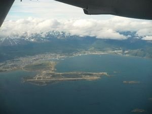
I was happy to make Pto. Williams and have a hot shower and clean clothes. It was a tough walk, but so worth it. I felt like I was the king of the world. Of course, that didn't last. Two days in Pto. Natales was more than enough for me (there really isn't much to do in that town), and even the gas stations use horses (see pic). A beautiful day dawned for my flight to Punta Areanas. Got some great shots from the plane of the Darwin Cordillera, which is the tail end of the Andes as they cross Tierra del Fuego.
Stayed just a night in Punta Arenas and then caught a flight to Puerto Varas. A holiday town, it's in the more developed part of Chile and feels a million times different than the south. It's very pretty though - looks like a German or Swiss mountain village, with a huge lake in front and a massive snow-topped volcano in the distance. I can see why the tourists and locals like it so much.
So, one more night here and then to Santiago for two nights before flying home. It's been an incredible trip so
far, and I'm a little sad it's ending. I'll try to do one more update from Santiago, but don't be surprised if I don't get to it.
All my best everyone!
P.S. Those who are on the postcard list should expect one from Pto Williams in the next six weeks. And if you want to be on the list for the next trip (Galapagos and then Africa), just send me an email! Thanks!
Advertisement
Tot: 0.116s; Tpl: 0.014s; cc: 11; qc: 60; dbt: 0.0741s; 1; m:domysql w:travelblog (10.17.0.13); sld: 1;
; mem: 1.2mb


popp
non-member comment
Twins?
You and Danny look like twins ..