Advertisement
Published: February 9th 2008

 Route to Volcan Lonquimay summit
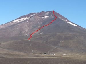
Our approximate rout to the summit, starting from the top of the lower ski lift. There's no path so you just walk up through the volcanic ash and stones until you reach the ridge below the summit. From there there's a fairly obvious but steep path to the top.The Central Valley area of Chile stretches south from Santiago as far as Temuco, and contains some of Chile's most interesting, though often overlooked, sights. Chillan was our first stop in the Valley. It's a busy town, birthplace of Chile's first President, Bernardo O' Higgins, but with little to attract travellers. As in other regions of Chile, it's the landscapes of the Central Valley rather than the towns that capture the imagination. We hired a car (a striking red Chevrolet Aveo) in Chillan and spent four days exploring these landscapes.
We drove down the Pan American to Curacautin, an access town for Conguillo National Park, and also for Reserva National Malalcahuello-Nalcas, both of which contain active volcanoes. Conguillio Park has been in the news recently following the eruption of Volcan Llaima on 1-Jan-2008. We were hoping we'd be able to get close to Llaima, but the park has remained closed since the eruption, and the volcano, in fact, has continued to sent large amounts of smoke into the air. So we concentrated on the reserva, where the last eruption was a slightly more reassuring 19 years ago.
Curacautin is a small town, but has a decent selection of

 Llaima still smoking...
Llaima erupted on 1-Jan-2008, and on Jan 31st it was still emitting gas. Conguillo National Park has remained closed since the eruption, making Lonquimay perhaps the best place from which to see it.hotels and one or two basic restaurants. It was too late that first day to do any serious hiking, so instead we found a hotel, then drove 31 km to Malalcahuello, the access village to the reserva, where we got all the information we needed on hiking. There are numerous treks in the reserva, but the one we were most interested in was climbing Volcano Lonquimay, the highest point in the area. On the way back to Curacautin we stopped at two different waterfalls, both very rustic and scenic, and far nicer than the Salta del Laja falls near Los Angeles, which we'd seen earlier that day.
Curacautin was covered in a thick blanket of fog when we arose the next morning, but, much to our surprise, as we drove towards the reserva, the skies began to clear. We turned off the main road at Malalcahuello, and drove along the dirt road to the ski center. Somewhere along this road Lonquimay suddenly came into view - it looked spectacular. The summit is at 2728 metres, a similar size to Villarrica, but almost entirely clear of snow. It looked worryingly steep and there was no obvious path in view so

 Salto del Indio
Salto del Indio is a nice waterfall near Curacautin. it looked like we'd be in for a tough day. We drove up as far as the refugio, where we had to pay a hefty 5000 pesos each to get into the ski center, though the friendly guy there did draw a map of the path to the summit on the back of our tickets.
The great thing about climbing volcanoes is the summits are usually in view for much of the climb, and that was especially important today given we were following back-of-an-envelope instructions. We parked our car at the top of the ski lift (appprox 1600 m altitude I estimate), then set off in the general direction of the summit. There was no path to follow, but we knew where we were aiming for. The surface we walked upon was all volcanic rubble - mostly ash, sand and loose stones. We tried to walk up in a zig-zag manner, but we kept slipping on the scree, so instead we tried to climb straight up, very difficult given the slope, but at least we started to get somewhere.
The higher we went the steeper it became, and we had to start scrambling, using hands as much as

 Start of the hike to the summit
It doesn't look too steep from here, but believe me it was!legs. We reached the ridge and took a long break. The views from here were excellent. We could see Volcan Llaima to the south, worryingly close and still clearly smoking. The famous Crater Navidad (Christmas Crater), formed from the last eruption of Lonquimay on 25th December 1988, had also come into view, just below us. On the ridge we heard a huge roar and for one scary moment I thought Lonquimay was erupting - it is active after all - but it was a thunder storm over near the Argentinian border. There was a lot of electricity in the air, meaning lightning was a possibility, but we'd come this far and wanted to see the top, plus the winds were blowing away from the mountain so I figured we'd be ok.
I began the final climb to the summit, while Ruth stayed behind as she had enough of the scree. The last hundred metres to the top, among loose, red volcanic rock was very difficult. Every two steps I took, I would slide back one, but I made it in the end, and what a sight it was at the top. The hge snow filled crater appeared below me

 Ruth on Lonquimay
This is the ridge that eventually leads to the summit. In the picture it looks deceptively easy, but the volcanic scree was very tough to walk upon.while, to the west, Volcan Tolhuaca came into view for the first time: it seemed to be almost in touching distance. There was more electricity in the air here - I could hear it eery time I opened my camera - so I didn't linger too long on the rim. The sand and scree that was impossible to walk up was a joy to go down on. I ran most of the way and we got back to the car very quickly. Back in Curacautin we trated oursleves to a nice dinner of churrasco, chips and a litre each of beer. It's not every day you climb an activa volcano!
Crater Navidad We returned to the Reserva the following day, still tired after the Lonquimay climb, but looking forward to more hiking on the moonlike landscape around Crater Navidad. Crater Navidad is a part of Volcan Lonquimay, and was formed when Lonquimay erupted in 1988. Over the next 13 months, volcanic material came out of the crater and a large amount of lava flowed eastwards. Nineteen years later the crater is surrounded by deserts of voclanic ash on one side and lave fields to the east. It looks absolutely

 Crater Navidad & Volcan Lonquimay
View from the dirt road which passes the volcano.amazing, one of the most spectacular sights I've seen in Chile, or anywhere for that matter. This area barely received a mention in our Chile guide book; if I was the author, it would be one of the top sights.
We parked the car on the dirt road above the crater and hiked down across the desert of ash. It took an hour to reach the foot of the crater. Then began another strenous ascent up the voclanic matter, which, like on Lonquimay, was very difficult to climb. There's still little vegetation in the area, though we noticed some plants, looking oddly out of place, growing on the side of the crater. Getting closer to the rim, the colours of the rocks became much more vivid. But that didn't prepare us for the top. We rerached the rim and gazed down into the crater, which was like a kaleidoscope of colours. Really stunning. To my surprise I saw smoke rising on one side of the rim and as we circled around we started to smell sulphur. Now, Navidad is supposed to be extinct (though Lonquimay is still active) and I didn't know if this was normal behaviour or not

 Araucaria Tree, Nahuelbuta National Park
At the Piedra del Aguila lookout, there is a super view over the park, and you can see good examples of Araucaris trees, which the park was set up to protect.so we were a little nervous on the top. I hope somebody in Chile is monitoring these volcanoes. We stopped for lunch at the base, on a spot overlooking the lava fields to the east. The contrast between this lava landscape and the green valleys beyond was striking.
Nahuelbuta National Park With some reluctance we left volcano land behind and drove onto Angol to the north, to see the less exciting though very scenic Nahuelbuta National Park. Angol is the closest town to Nahuelbuta, so we booked into a hotel here before going onto the park. It took much longer than we had planned to reach the park as the only access is along a dirt road for 33km from Angol. That gave us time to do just one hike, so we chose the Piedra del Aguila trek, an 8km return hike which leads through beautiful forest to a lookout over the park. The park was set up to protect the Araucaria trees, which we could see all throughout the hike. When we reached the viewpoint however, we had the best view of them as we were looking down all over the park. There was too much haze to

 Crash on the Pan American
You can see on the right of the picture smoke from the burning car. Cars behind all stopped here, which in turn led to a crash, with most of the damage being done by the green truck. Our car is the red chevrolet which luckily was undamaged. see the Pacific or the mountains but the view of the park was more than enough.
Pan Am Crash We had a lucky escape driving back to Chillan from Angol. Just beyond Los Angeles we noticed smoke on the road ahead - it appeared a car was on fire. A few cars in front of us had pulled in so we did likewise, unsure if we could pass. Suddenly, out of nowhere, this mad truck driver comes hurtling down the Pan-Am, clips our wing mirror, bashes the car in front of us, and rams into one of the vans ahead which had stopped. He clearly hadn't noticed the smoke, and was going at full speed, whereas everyone ahead of him had pulled in. I was sure he had dented the side of our car and was very surprised to find we had got away with it. The car in front wasn't so lucky while the van was in a terrible state. We had to wait around till the police came and tried to sort it all out. That one problem ahead with the car on fire had lead to 5 cars being damaged as they slowed down to watch
it. Luckily no one was hurt. So leaving active volcanoes and mad truck drivers behind we said our goodbyes to the Central Valley and moved north to Santiago.
Advertisement
Tot: 0.372s; Tpl: 0.016s; cc: 24; qc: 115; dbt: 0.2622s; 1; m:domysql w:travelblog (10.17.0.13); sld: 1;
; mem: 1.4mb


Mum
non-member comment
Fantastic heights
Hi Barry - where are you getting all the enegy from to do all that wqalking. The scenery and heights are fantastic