Advertisement
Published: April 19th 2008

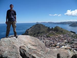
 Summit of Cerro Kesanani
Kesanani is 4014 m high and looks over Copacabana. Below the summit is Horca del Inca, an Inca observatory site.Copacabana was the perfect place to end our travels in Bolivia. Situated on the shores of Lake Titicaca, at a breathtaking altitude of 3841 metres above sea level, Copacabana is the type of place you plan to visit for a day and end up staying a week. It's just one of the many towns in South America that live off tourism, but nevertheless it's a very pleasant place to visit.
The trip from La Paz to Copacabana is memorable. First you climb our of La Paz, onto the bleak Altiplano, with the high peaks of the Cordillera Real to the east providing a fantastic backdrop. Soon you approach Lake Titicaca, and at one of the narrowest points, you cross the Strait of Tiquina from the hamlet of San Pablo to the slightly larger hamlet of San Pedro. We had to disembark from the bus and cross on the passenger ferry while the bus was transported separately. The crossing is operated or supervised by the Bolivian Navy - apparently Bolivia is the only landlocked country in the world with a navy. Bolivia adamantly wants it's coastline back so I guess keeping a navy is a sign of this determination. From

 Guinea-Pig for lunch anyone?
Friendly local lady on Isla del Sol though you have to feel sorry for the Guinea Pigs! San Pedro a winding mountain road lead up to a pass, where Copacabana finally came into view and from there it was a short descent into town. Copacabana's market was in full swing when we arrived and I almost knocked over a sheep's head as we struggled past the meat stalls on our way to the hotel. Hotel Utapu offered us a room with a view of the lake for only 120 Bolivianos per night (about 16 dollars) - no wonder people like Copa so much!
As we were already well acclimatised we set out to explore town. One of the most popular spots is Cerro Calvario, a 3966 metre high hill overlooking the town and the lake. It's a steep hike up to the top, past 12 stations of the cross, though it only takes about 30 minutes in all. The trek is something of a pilgrimage for locals, and there were far more of them than backpackers on the mountain on all three occasions we climbed. Many of them leave offerings as a thanks or as a way of asking for good luck. Where there is demand in Bolivia there is nearly always supply and both at
the summit and the halfway point there were kiosks selling drinks and souvenirs for tourists and candles and offerings for the locals.
The views from the top of Cerro Calvario were excellent. The vast Lake Titicaca appeared more like a sea than a lake, not too surprising when you consider it's 190 km long and 80 km wide. As well as being the world's highest navigable lake, Titicaca is also a scared place in Andean culture, being the mythical birthplace of the Inca civilisation. The lake contains many islands, and we could see on of these, the legendary Isla del Sol, in the distance from the top of the hill. To the west we had our first view of Peru. Cerro Calvario is also a popular sunset viewing spot so we walked up the steps once again that evening.
The Challah Ceremony A peculiar tradition in Copacabana sees locals congregate at the cathedral at weekends to bless their vehicles in ceremony known as challah. We went along to see this spectacle on our second day in town (which happened to be Sunday) and I couldn't believe my eyes when I saw the huge queues of cars, vans and

 Native Altar on Isla del Sol
An Inca site at the north end of the island near Chinkani.buses, all bedecked in flowers, awaiting blessing from the priest. The challah was taken very seriously. Entire families were present, many dressed in their finest clothes, while what seemed to be alcohol offerings were being made during the ceremony. I saw plenty of bus drivers there too - given the roads some of these drivers have to take and the way they drive, I think more than blessings and prayers are required. We wandered into see the cathedral too, and it was interesting to note that there were much fewer people inside than outside at the ceremony. I wonder what the church leaders make of all this!
We followed a path behind the church and up another hill to Horca del Inca, an Inca stone sculpture, which archaeologists believe was used as an observatory. It was another steep hike up along a well worn path, but again it was well worth it for the views, which we had to ourselves for a few moments until two local kids came along and tried to offer their services as tour guides. From the Horca del Inca we continued to the summit, a marvellous hike, in fact more of a scramble really

 Bolivia's subtle message to Chile
Read the fine print on this sign at Lake Titicaca.along a difficult path. The views here were even better than from Cerro Calvario, and we were at 4014 metres, my fourth highest peak! Starting at 3800 did make it fairly easy, however.
When you say Copacabana most people think of the beach area in Rio, but Bolivia's Copacabana has a beach too. I haven't been to Rio's Copa but I imagine it's very different to what you see in Bolivia. Later that day we hiked out alongside the beach to the end of the headland and while the views back to Copacabana and out across Titicaca were spectacular, the path was pretty bad. Some parts were used as a rubbish dump and the smell was horrible. We passed lots of cars which had been blessed in the Challa ceremony earlier that morning. Some of the locals were even in swimming in the very cold lake water.
Isla Del Sol The highlight of Copacabana for many people is a visit to Isla del Sol, the largest island on the Lake. According to Inca legend, this was where the Manco Capac (the first Inca) and Mama Ocllo arose from the water to found the Inca race. The islanders live
traditional lives and despite the huge numbers of tourists who visit here, it felt untouched and untainted in many ways. It's a 3 hour journey by boat from Copacabana to Challapampa on the north side of the island. Fromt here we had 4.5 hours to explore the island ourselves before meeting the boat at the southern end.
Isla del Sol is 9km long and 6km wide. There are 3 villages on the island, which is home to about 1000 people (according to what a local man told me - it appeared to me there were fewer people). A series of paths connect the villages and lead to the major sites scattered around the island. We picked up a useful map in Copa showing the islands main sights though to be honest it's easy enough to find the way yourself. I was expecting Isla del Sol to be something of a tourist trap but for the most part the locals seemed to be getting on with their own thing and not trying to sell the island too much. As we walked from Caaa to the north of the island we were joined by a local farmer for a few minutes.

 Cerro Calvario
View from Cerro Calvario, a pilgrimge site for many locals. He said not too many tourists spoke Spanish so he didn't get too much opportunity to talk to visitors. He pointed out a few Inca sights to us as we climbed, and just as I was expecting him to offer his services as a tour guide he said goodbye, hopped over a wall and set off across the fields to wherever he was working. We picked an interesting time to pass the local school. Apparently it was toilet break for the whole class, which meant 15 or 20 young kids standing in the field doing their thing, not a bother on them! Some of them even shouted "Buenos Dias" to us!
The first site we visited was Chinkana (aka the labyrinth), a maze like Inca stone building, near the northern end of the island. I'm unclear what exactly it was used for, but it was an elegant site. Beside it was the Inca chair, another stone. We decided to stretch our legs a bit and walked to the summit of nearby Cerro Thicani, at 3936 metres high. The views from the top were stunning, we could see much of the island, including the north to south ridge path that

 Copacabana Beach
The Bolivian versionawaited us. We also had a great view of the maze and of the other islands near Isla del Sol.
We then began the long walk along the ridge path in the middle of the island. This was a fantastic hike. We took brief detours along the way to climb three more peaks (Cerro Calvario a 4027m, Cerro Santa Barbara at 4032m and an unmarked peak), all well worth doing as from the top you get views of both sides of the island and of the towns along the eastern side. If you stick to the path you miss a lot. As we arrived in Yumani, we passed many locals working on the paths. They were very friendly and all said hello. Some even stopped for a minute to chat. It's difficult to believe that such an influx of tourist hasn't lead to the island becoming more of a tourist trap. Long may it last!
We arrived back in Copa at 5.30 just in time for sunset, and as it was our last evening in Bolivia we planned a good evening. First we sat watching the sunset, drinking pisco sours, at a terrace bar opposite the beach. Then
we had a lovely dinner in a quiet candle lit restaurant in the main street. It was a family run place with a delicious menu for 15 Bolivianos and our waitress was one of the daughters. I reckon she was about 12. The kids in Bolivia sure work hard! Next morning it was bye bye Bolivia, hello Peru as we travelled the short distance to the border, continued to Puno, and continued our exploration of Titicaca from the Peruvian side.
Advertisement
Tot: 0.09s; Tpl: 0.015s; cc: 8; qc: 24; dbt: 0.0424s; 1; m:domysql w:travelblog (10.17.0.13); sld: 1;
; mem: 1.1mb


