Advertisement
Published: February 14th 2009

 Caviahue - Viewpoint
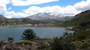
Caviahue, the lake ant the Copahue volcanoLast holidays we decided to go to
Caviahue, a small tourist town in the province of Neuquen, 1526 kilometers of Buenos Aires and 23 hours of travel by two different buses. It is located 1600 meters above sea level, on the shores of the lake of the same name and on the slopes of the Copahue volcano of 2953 meters in height - the only active volcano of the Argentine Patagonia. Last year we had stayed in Copahue and we went over the area, but we want more, we want to take walks in the natural environment, away from noise and crowds of the city ...
The village of Copahue (at 18 kilometers) is recognized by the properties of his thermal waters, sludge and vapors. This place unoccupied in the winter, when snow covers it completely and it can only be reached by snowmobile or tracked. Winter is the high season in Caviahue for its ski resort, while the summer is the peak in Copahue and its spa.
This entire region is within the 27,000 hectares of Protected Natural Area of Copahue, where the intense volcanic activity from millions of years ago was marking his face. A super
crater occupied where it is now the Caviahue Lake, fumaroles had been found in its deep and has no fishes. Agrio river rises in the volcano and will also be dragging mineral acid and sulfur, which is feeding the lake.
Despite the aridity of the area, there are some vegetation that distinguishes the
"Araucaria araucana" or
"pehuén" , a symbol of the region, both in Argentina and Chile. Originated some 200 million years, some specimens exceed 1000 years old and reach 50 meters in height. There are male and female pine, whose nuts are eaten by mapuches and Pehuenches, old inhabitants of the place.
The
"mallines" grow in the mountains, near streams and they are very green, flush from the floor and appeared to touch plastic ... In the summer these small plants are covered with flowers like the
"Flower of Copahue" .
As for the animals in the area, we could see more lizards, bustards, bandurrias and seagulls. In the volcano we can see four youth condors planning very close to us ... Many inhabitants of the place of Mapuche descent are small “crianceros” with sheep, goats and horses that roam

 Copahue volcano
Little steam in the craterthe region in the summer to feed their animals, is what they called the
veranada . During the winter sets in the fields below, until the snow melts and the grass grow again.
Rivers and streams form numerous waterfalls and cascades. The
Agrio River , whose birth could be seen when one goes up the volcano, go down by basaltic terraces and so many waterfalls can be seen along a circuit more or less marked, with the forest of “pehuenes”. A path bording the river reaches the viewpoints of the Basalt´Cascade, the one called “The hair of the Madonna”, “Snake´s cascade” and “the Giant”. Where there are the last araucarias and begin the mountains vegetation you can see the “Large cascade”, a few miles from Chile by the Pucón Mahuida pass.
Another hike is to reach the
Cascada Escondida (Hidden Cascade), through a path of 1800 meters long between trees like ñires, pehuenes, some lengas along the Sweet Creek. It is a cascade of about 15 meters high and you can reach below the waterfall, though it is a little more difficult. On the hill behind Caviahue it’s the Laguna Escondida (Hidden lagoon)
to which you can get up among the rocks or along a path with no signal coming from the base of the ski resort, but we could not find it ... By the Caviahue lake are beautiful beaches of sand and little stones with araucarias, and a viewpoint that was reached by the road to Copahue, from which it has a good view of the lake, the village, the volcano and the forests of pehuenes.
It's worth taking a day to go to the village of
Copahue , either to take advantage of the spa center and enjoy the hot springs, or for those who enjoy walking (our case) there are some very Interesting: you can go to the "Balcony of Copahue" from where you have a magnificent view of the volcano, and the “Lagunas Las Mellizas” (Twins lagoons) supplying water Caviahue which are freshwater. Another path you can take is the boundary post to the border between Argentina and Chile, among mountains, mallines, streams and patches of snow, a road normally used by Mapuches and Pehuenches from the Bio Bio Valley and that they go to sell their crafts to Copahue.
A kilometer from Copahue is "The

 Cascade
The name of this one is "Hair of the Madonna"little machines”, all-natural hot springs where bathing is possible, with minimum facilities. The name is due to noise that is in place, led by fumaroles and vents, and there is pools with hot water and mud.
One of the most beautiful places in the area (at least for me), is located in the valley of Trolope: it’s the
"Salto del Agrio” (Agrio waterfall) , a cascade about 45 meters high which drops to great green pool surrounded by basaltic rocks. It's really amazing the contrast with the green water and the yellow and red colors of the rocks; if you go in the morning, you can see the rainbow produced by the falling water. We crossed the river by the Agrio Bridge, which is next to the hostel where the owners make craft beer.
There are other places we had no time to visit like the “Riscos Bayos”, “Cajón de los Barros”, Hualcupén lake, the valley of Chinchiví ... One week is not enough, especially when you go without car ...
But undoubtedly the star of the site is
Copahue volcano ... and we went towards him ... We depart on an excursion of approximately

 Giant´s cascade
With the volcano behind7 hours, with a perfect day, sunny and no wind. The first part of the trip does not require efforts because we went with a Russian combi 4x4; we went through the Mellizas lagoons and the geothermal plant. This plant was built to provide steam to the coils that were installed beneath the streets of Copahue to be free of snow in the winter, but the materials used were not adequate and now everything is out of service. Then we began to climb the volcano's slopes until a little further up the hill called Mesa. From then on the walk began in a mountain landscape, moonscape ...
Ascending, you can see the Andes mountain range, several peaks and volcanoes as Peineta, Antuco, Tromen, Domuyo and deviating some of the road, we managed to see the Lanin. We climbed up a rocky terrain with small loose stones, sand patches of ash and ash-covered ice, product of the last eruption of the volcano in July 2000.
At one point we crossed the Agrio river, at that point it is just a stream, but its hot water and the colors red and yellow of the stones and rocks remember us that the

 Copahue
Sulphurous lagoon in the Spa centerriver born in the heart of the volcano. A little further up we could see the river emerging among the rocks and patches of snow. In the air we could feel a strange smell, strong, because of the sulfur and when we reached the crater we can hardly breathe, but fortunately was only a moment ...
We entered the crater through the opening in a "V" which is visible from Caviahue. The view of the crater is really wonderful: the crater is occupied by a grayish bubbly lagoon surrounded by stone walls, surrounded by a hanging glacier.
The guide told us that before the last eruption, in the lagoon were great bubbles nearly two meters in diameter, one day the lagoon disappeared, the volcano's mouth opened and pushed out lots of rocks and ash that covered the entire area, but no lava. .. Later the crater closed the mouth and in five months the lagoon was like we saw it.
Besides the magnificence of the crater, you see the spectacular view from that height ... It seems as if you were reading a map. You could see Copahue, Caviahue and the U-shaped Caviahue lake, The Twins lagoons , and

 Copahue
The water of the Sulphurous lagoon is at 70/80C temperaturevery clear what makes covering the mega volcano millions of years ago ...
After a light lunch consisting of cereal bars, candy and lots of water, we began the descent. This was much more fun and light, the ashes were like sand and we went down very fast like skating, but the drawback was that we filled the shoes of ash and small pebbles. Later we were again crossing the Agrio river, where we stop and take out the stones and all that had entered into our shoes ... We arrived to the rocky terrain again, where we had to pay attention because of the big slope of the path. Finally we reached the minibus. The faces of satisfaction of all of us spoke more than a thousand words: The effort was worth it!!!.
Advertisement
Tot: 0.181s; Tpl: 0.02s; cc: 10; qc: 49; dbt: 0.0514s; 1; m:domysql w:travelblog (10.17.0.13); sld: 1;
; mem: 1.2mb


