Advertisement
Published: October 14th 2017

Kepler TrackNew Zealand is home to some unique and remarkable scenery. Dramatic fjords, impressive volcanoes, rugged rolling hills, striking mountains, eye-catching glaciers and sweeping coastlines make this country a hugely popular tourist destination and for the adventure minded traveller New Zealand has to be among the very best. After travelling through this lovely country for almost a month I do understand why people speak so highly about it.
One of my main reasons for coming to New Zealand was to explore some of the hiking and trekking routes around the country. I knew my options were many and plentiful and when I left my homecountry I already had an idea on what and where I wanted to go. My only slight worry was that the somewhat rough and unpredictable weather parts of this country sometimes receives, would spoil some of my ambitions.
Shortly after arriving in Queenstown on a laung-haul flight from Europe I had my first taste of what this country has to offer by taking the superb day walk all the way up to the summit of Ben Lomond at 1748 m. With its great extensive 360 degree panorama views and easy access from town this is a
Lake Te Anau and Mount Luxmoretrip well worth doing. A good workout and warmup for the coming weeks ahead.
Next day I was on the bus down to Te Anau and the Fjordland National Park which is home to three of New Zealand's so called "Great Walks" -The Routeburn Track, Kepler Track and Milford Track. With a total of more than 30.000 visitors each year these treks are among the most popular in the New Zealand offering a fine glimpse into some vast and remote areas of the southern tip of this country.
Milford Track is by far the most famous and well-known trek in the whole of New Zealand heavily promoted as " One of the finest walks in the world" by the tourism industry in the country.
I personally heard about this trek for the first time many years ago and very often when I talk with people about different hiking places around the world the Milford Track always seem to pop up during the conversations. After travelling such a long distance and for so many hours my time had finally come to fufill my long time curiosity for this mythical and so much talked about trek.
With my
Control Gate, the offical Kepler Track starting pointpre-booked ticket for the regulated 4days/3nights option ( I did the booking 6 months in advance ) I spent some fine days of walking in the very heart of Fjordland starting from Glade Wharf on the very tip of Lake Te Anau ending my trip 53,5 km later in beautiful sunshine at the scenic Sandfly Point in Milford Sound.
This historical track certainly gives what it promises in terms of wet weather, rich wildlife, remarkable cascades ( Sutherland Falls and MacKay Falls were both amazing ), great alpine views on the windy MacKinnon Pass and some extremely knowledgeable hut rangers at Clinton Hut - Ross, Mintaro Hut - Jules and Dumpling Hut - Helen. The famous Kea bird will certainly bring a smile on your face as you go unless it gets away with some of your stuff that you left outside to dry :-) And, yes, the notorious sandflies here will not give you a peaceful moment. They do bite in multiple thousands !
Milford track was certainly a walk well worth doing, but do I agree to the statement that this is " One of the finest walks in the world " ? . No, I
Starting long the climb from Broad Bay to Luxmore do not !
I am not even sure if it would make my top 10 list of the many walks I have done over the years. If I say Kangchenjunga Trek, Manaslu Trek, Annapurna Circuit, Makalu Trek, Everest & Gokyo trek and Langtang Trek in Nepal, Alta Via Trek in Italy, Haute Route in France/Switzerland, Tour du Mont Blanc, Tour of the Vanoise and GR20 ( Corsica ) in France, Torres del Paine Circuit in Chile, , they are just a few I would rate higher than Milford.
Back in Te Anau after 4 days of trekking I only had one day to re-organize my stuff before switching to my next walking adventure. This time the not so famous Kepler Track was on my walking agenda.
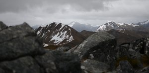
The Kepler Mountains are located on the eastern edge of the Fjordland National Park very close and clearly visible from Te Anau town. In 1988 the Department of Conservation opened a trekking route in this mountain range and named it the Kepler Track.
Since its opening the trek has become more and more popular and is now visited by more than 10.000 people each year. Most people start their walk
The iconic limestone rocksfrom a place known as the Control Gates about 3-4 km south of Te Anau town center. Here there are two trail options to choose from. Since the Kepler Track basically is a full circle trail stretching some 60,1 km the decision to do it clockwise or anticlockwise is all about personal preferences. The majority of trekkers do it anticlockwise.
Day 1 : Te Anau 215 m. - Luxmore Hut 1085 m. 4h05m 18 km My day started at the Freshchoice Supermarket in the center of town stocking up on some high energy food for my upcoming days in the Kepler mountains. The excellent selection of dry foods with different flavours and extensive variety of other items left me with many options this morning and I had to pick wisely not to end up with too much weight in my backpack.
Outside it was another day of fine, clear weather absolutely perfect for some long distance walking. My ambition this morning was to reach the Luxmore Hut located some 18 km to the west high up in the Kepler mountains and spend my first night there. Except from a sligthly sore ankle which I had
Emerging into open mountain terrainpicked up in Milford my legs and shoulders felt surprisingly good despite only one rest day between the two treks.
I left my hostel at 10 am and quickly found myself walking alongside the pleasant Lake Te Anau with some fine views of the Kepler mountains and Jackson Peaks across the water.In some of the higher places there were still some tiny traces of snow left from winter, but other than that conditions looked pretty much perfect.
The water taxi which runs between the edge town to Broad Bay ( 5,6 km into the Kepler Track from Control Gates ) across the lake may be a tempting shortcut for some and can save 2-4 hours of easy walking. This was never an option for me. My legs would be my only mode of transportation for the upcoming 60 km.
It took me about 10 minutes to reach the The Fjordland National Park Visitor Centre, located next to the lake, where I would pick up my pre-paid tickets for the huts and get the latest information about the weather and the trail. This place has absolutely everything you need to know about the Fjordland area and can give
Tip of Mount Luxmoreyou every little detail you need to know about your specific trek. Safety is their highest priority and it is really worth listening to what these people have to say before you go.
My main concern was what the weather would be like in the next few days and was quite pleased to se on the weather update board that the forecast looked fairly ok, but not super perfect. A little bit of wind and some raindrops along the way was fine with me.
A sign outside the Visitor Centre said " Lakeside Walk ", with arrows pointing 45 min. to the Control Gates, guided me on to a well laid out dirt road that would eventually take me to the entrance point of the Kepler Track. This easy walk went alongside the south western tip of Te Anau Lake offering fine open views of the Kepler range, Jackson Peaks and the tip of Mount Luxmore, where I would go tomorrow. If the weather is favourable this really is a nice introduction to the Kepler Track and a stroll well worth doing before entering many hours of forest walk which follows just after entering the offical track
Amazing views of the Te Anau lowlands and beyondAfter a little bit more than 3 km of leisurely walking I eventually arrived at the concrete walls which regulates the water flow between Lake Te Anau and the hydro electric powerstation at Lake Manapouri further to the south. This is the place they call Control Gates and this is where the Kepler Track starts for most people.
I took my time to check out the information board at the very start of the trail which had a map of the area, some light information about the Kepler Track ( distances and timings between key points ) and a story about the Waiau River which links Lake Te Anau and Lake Manapouri.
A few meters ahead the trail splits into two and this is where you have to decide which direction you want to take. This junction is well signposted and it is almost impossible to take the wrong turn. I had already decided to make the anti-clockwise version and according to the signpost it would take me 6 hours to reach the Luxmore Hut today.
The first 5,6 km of walking from Control Gates to Broad Bay was as easy as a walk can possibly get
Endless footbridge near Luxmore Huttaking me through nice beech forest on a well laid out trail next to a quiet Lake Te Anau. Except from two people doing trail running I did not see any other people around this morning perhaps indicating that this was at the very start of the official trekking season this year ( October 2016 ). According to statistics more than 10.000 people do the Kepler Track each year.
With all the easy work behind me I knew I was in for some harder hours soon after leaving Broad Bay ( signpost saying Luxmore Hut 4.30h & Iris Burn Hut 10h ) Ahead of me I had a climb of nearly 800 altitude meters which eventually would take out of the forest and up into the open mountain areas.
Winding its way up through the tree covered area the incline did not feel as strenous as I thought it would be, but for some of the other people I passed on my way up I could sense that they were struggling a bit more judging by their vocal expressions.
About 1h20m after leaving Broad Bay I reached the steep overhanging limestone rocks, a famous landmark and attraction
Tip of Mount Luxmore slightly to the righton the Kepler Track. Aided by some solid wooden steps you literally walk underneath the vertical wall of rock as you go up and it is well worth spending a few minutes here taking photos and admire iconic walls.
Less than 30 minutes after passing through the limestone section a completely different scene appeared ahead of me. Suddenly I was standing at the very edge of the bushline with open and uninterrupted views all around me surrounded by alpine tussock grassland in every direction.
Ahead I could spot the tip of Mount Luxmore and moving my feet a little bit further I had magnificient panorama views all the way down to Te Ananu and beyond including some far away snow capped peaks.
The somewhat strong wind after coming out of the forest was a reminder that I was now walking in much more exposed terrain but fortunately it was still dry and pretty comfortable considering that I was now in an completely unprotected area. The last bit of walk up to the Luxmore Hut at 1085 m. was easy and highly enjoyable crossing some long foot/wood-bridges along the way and getting some fantastic long distance views of
Luxmore Hut located at 1085 m.the Takitimu Mountains, Snowdon, Earl Mountains, Murchison Mountains and the impressive lake Te Aanau with its many fjord arms.
I arrived there at 2.45 pm. This place has beds for almost 60 people shared between two dormitories. In the Great Walking Season from October - April the hut is staffed by a conservation ranger and basic cooking facilities and running water is availiable for its guests. What separates this hut from the other lodges on this track definately has to be its fantastic location offering some amazing views across to the Murchison Mountain and down towards the blue waters of Lake Te Aanau and the land stretching beyond that. Inside the dining area you really get a cooking with a view :-)
The majority of people coming up here also do the 10 minute side-trip to visit the Luxmore caves where you can venture underground to get a glimpse into the world of stalactites and stalagmites and its rock formations. My own adventure into this dark slippery hole was cut short by my poor head torch forcing me to stop almost at the entrance.Message is : bring some better light than I did.
In the afternoon me
Tussock land with brilliant viewsand the few other guests here this day were given an excellent 1 hour outside tour by the hut ranger who shared some of his formidable knowledge about the flora and fauna of this particular area. There really were some interesting details to take notice of. Highly recommended !
Like on the Milford Track, and probably also on the other "Great Walks" organized by the Department of Conversation, a hut talk is held every evening by the ranger in charge where all the guests are given a thorough review on next days weather forecast, the trail ahead and what to except, safety issues in the lodge and hut-etiquette. I was quite pleased to hear that tomorrow looked ok, though we could expect a bit of wind and perhaps some spells of rain during the day. Before jumping into my sleeping bag I made sure my raingear and windstopper was easily available in my backpack .
Day 2 : Luxmore Hut 1085 m. - Moturau Hut 215 m. 8h25m 30,8 km I was the first guest to crawl out of the sleeping bag and head downstairs for breakfast in the spacious dining hall looking
Luxmore Hut and Murchison Mountainsforward to be trying my improvised sandwiches which I had prepared yesterday in Te Anau. A big early meal was essential since I knew I was in for some long hours on the trail hoping to reach Moturau Hut by the end of this day.
Outside the beautiful pink daybreak colours had been replaced by some darker and wetter looking skies sitting like a blanket over the rolling Kepler Mountains. Yesterdays weather forecast announcement by the hut ranger seemed to be spot on by just taking a glance out of the window. Rain seemed very likely and right now it was not a question of IF, but WHEN the clouds would burst.
I was out of the door a little after 7 am. A sign just outside the hut said it would take 6 hours to reach Iris Burn Hut 14,6 km away, the next lodge on the Kepler Trek. With double layers of clothing and a bit excited to be on the nicest and most scenic sections of the Kepler Track I trodded my way towards the slopes of Mount Luxmore. The trail was well maintained and easy to follow with a modest incline, enough to get
Window view from Luxmore hut dining halla good warm up this morning. Crossing a few foot bridges and a tiny snow field I soon found myself walking along the north-west facing side of the Luxmore summit passing a sign saying that I was now entering a "Fragile Area".
A few minutes further another sign pointed left away from the main trail marking the entry point for the short climb to the summit point of Mount Luxmore. The 10-15 minute walk from this junction to the 1472 m. peak is well worth the effort and a must do in my opinion. The views from the summit point are absolutely incredible. I think Johannes Kepler must have been proud man to have these mountains named after him.
From my position I had a birds eye view of Te Anau and the lake looking east, the Jackson Peaks, the Takitimu Mountains and Lake Manapouri in the south/east, the Murchison range to the north and to the west the rolling Kepler hills with the trail dwindling its way up and down endless ridges as far as the Hanging Valley Shelter. If it was not for the strong wind up here this morning I easily could have spent an
The wonderful Kea birdhour or two just soaking up the wonderful vistas.
Back down at the sign junction the trail continued to descend for a while to a narrow ridge reaching Iris Burn Shelter 1270 m. at 8.50 am. This small emergency shelter provides an escape for trekkers who find themselves in trouble in the mountains. . A toilet is also available for those in need.( a sign at the shelter indicates 2 hours to Iris Burn Hut )
In winter season both sides of the Forest Burn Shelter are high risk winter avalanche places and deserves the highest respect. Today, however, snow was not an issue but coming up on the other side of the shelter I do understand why this can be such a tricky and dangerous place in icy and wintery conditions.
After traversing the steep hillside for about 30 minutes I reached the start of a long, open, undulating and very weather exposed ridge that I would follow for the next hour or so. The trail, balancing its way like a wave through rolling hills and tussockland, looked really awesome from my position. According to the hut ranger at Luxmore this particular section of the Kepler
Te Anau township belowTrack could sometimes receive some ruthless winds exceeding 100 km/h forcing trampers to crawl their way forward. Fortunately this would not be the case today and I was pretty sure that I would be able to complete this ridgewalk without the help of my swimming skills.
With the impressive surroundings and favorable wind conditions the walk was highly enjoyable and it was not until I reached the Hanging Valley Shelter 1390 m. at 10 am I could feel the first light raindrops and the wind starting to pick up a bit. I made a short rest stop here to refresh myself before the long drop down to the Iris Burn Hut. Sitting on the tip of the ridge this emergency shelter makes a good lunch spot for people coming in both directions with views of Mount Tinsley 1547 just across and the Iris Burn Valley and River far down below. While resting my legs and shoulders I had the pleasure of witnessing a beautiful rainbow wrapping its colours around the peak named after the New Zealand cosmologist Beatrice Tinsley. right in front of me. The white toilet box standing next to the shelter is almost a tourist attraction in
Heading up to Mount Luxmore on Day 2itself standing literally on the very edge of a cliff supported by some tiny wires on each side and with some unbeatable views.
I remember from yesterdays hut talk the ranger told us to be a bit careful on the ridge descent from Hanging Valley shelter. The combination of wind gusts and some steep steps could potentially be a bit challenging and tricky on this exposed piece of the track and encouraged us to be careful while descending. I made my way down in one piece without any problems and reached another sign ( at 10.30 ) indicating " Iris Burn Hut 1h30m " .
The sign marked the end of open uninterrupted alpine terrain and the beginning of green mossy forest with limited views. I had not met or seen any other people on the trail this day until walked into a group of 4 trekkers coming in the opposite direction working hard to get up some the steep switchbacks towards the clearing. They definately had the best part of the Kepler Track ahead of them while I continued into sandfly territory looking forward to rest my sore ankle a bit at the Iris Burn Hut. I
Still approaching Mount luxmorelater learned that about 10 % do the Kepler Track in the opposite direction.
I started to rain more heavily when I emerged from the forest and reached Iris Burn Hut 497 m.at the bottom of the valley before noon. The hut did not seem to differ much from the other lodges on the Milford or Kepler tracks pretty much built by the same principles and with identical facilities. There was nobody else around except the hut ranger when I arrived which meant I had the luxury of having the whole dining hall all to myself for lunch. It was quite pleasant to just sit down and relax for a few minutes without an aching backpack on my shoulders after walking for almost 4,5 hours since Luxmore.
With lots of daylight left I was debating wether I should stay here or continue to the next hut at Moturau some 16 km down the trail. Since my ticket was booked for this specific lodge I had to check with the ranger if I was allowed to make a change to my reservation and spend the night at the other place instead. With so few people on the mountain this
Lake Te Anauearly in the trekking season she did not believe I would have any problems getting a place to sleep at the next refuge and gave me the nod to continue.
It was still drizzling quite a bit when I set off from Iris Burn Hut around noon. A sign indicated 6 hours from here to Moturau which I thought was a very generous estimate knowing that the trail was pretty much flat all the way. Taking breaks longer than a few minutes along the way was not a very tempting option either knowing that the sandlfies would literally terrorize me with their intimate presence if I did.
At 1.45 pm I reached Rocky Point Shelter the halfway point between the two huts. This place was nothing more that a roof with a few tables and benches and an enormous amounts of sandflies.
Walking in forest for quite some hours my excitment level went up a bit when I eventually had a break from the world of green mossy colours and got my first close glimpse of Lake Manapouri and the Shallow Bay area ahead of me. This is the second largest lake in the Fjordland National Park
The undulating Kepler Hills aheadand the second deepest in New Zealand. The inland sea is dotted with 33 small islands.
Getting a bit closer a white sandy beach appeared next to the trail adding to a very scenic environment. This was my time to slow down my pace a bit and appreciate the fine surroundings before taking the last few steps to my end destination this afternoon.
After more than 8 hours and 30 km of walking since Luxmore I finally arrived at the Moturau hut where I was greeted by the lively hut ranger who was out cutting some branches to make better space for helicopter to land. With the hut less than half full there was plenty of bed-space to pick from and found myself a quiet corner on the second floor hopefully without too many snorers.
One of the things that really stands out about this place has to be its sunset views. Watching the sun go down over Lake Manapouri and the distant mountains looming behind is in my opinion one of the highlights on the Kepler Track.
Day 3 : Moturau Hut 185 m. - Control Gates 185 m. 3h10m 15,5 km
Entering the steep Mount Luxmore slopesMost people had already left the building when I came downstairs to have my breakfast in a completely empty dining hall on my last day on the Kepler Track. Some of them were moving upvalley to the Iris Burn Hut while others were finishing their trek trying to reach the shuttle bus at Rainbow Reach leaving at 10 am.
Weather this morning was similar to when I started this trek two days ago with fine and dry conditions and by the looks of it I did not have to worry about getting any of my raingear out of the backpack this day.
I left Moturau Hut at 8.35 am escaping into green beech forest again alongside Lake Manapouri on a wide and excellent trail pretty much flat all the way. About twenty minutes into my walk I reached a fork with an option of going to the Shallow Bay Hut ( 15 mins. ) or continue on the main track ( Rainbow Reach 1h15m & Lake Te Anau Control Gate 5h ) which I did.
. Another 5 minutes ahead a wooden walkway across some open wetland has been built leading to an observation platform
Sign marking the side trip to the Mount luxmore summitwith views across an unnamed lake and the surrounding swamps. These wetlands are apparently home to some unique plants and insects.
After hiking for 6 km ( 9.50 am ) I reached yet another junction with an option of crossing the Rainbow Reach Bridge leading to a shelter and carpark which connects with the Manapouri - Te Anau Highway. Cutting my walk here was not an option despite knowing that the 10 am shuttle bus would save me 3-4 hours on the trail. Instead I proceeded alongside the quiet Waiau River enjoying the warm sunshine and nice surroundings.
I met more people on the final few kilomteres of my walk than what I had done on the entire track so far getting into a nice conversation with an aunt and her nephew from Sydney, meeting some workers doing maintenance work on the trail and saying "Hello" to the many trail runners coming up and down the riverbank. Maybe some of them were out preparing for the annual Kepler Challenge which is held every year in December taking runners around the entire Kepler Track with start and finish at Control Gates. The fastest recorded time was back in 2013
Approaching the summit areatime and stands at 4:33:37 !!!
My Kepler track adventure ended on 15h40m and in that time I had the chance to thoroughly enjoy and appreciate this wonderful area which I definately can recommend to anyone who is planning a holiday to the beautiful New Zealand.
PS ! This trip took place October/November 2016
Advertisement
Tot: 0.177s; Tpl: 0.027s; cc: 18; qc: 76; dbt: 0.0929s; 1; m:domysql w:travelblog (10.17.0.13); sld: 1;
; mem: 1.5mb


