Advertisement
Published: January 26th 2014

 Starting Point
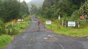
Entrance to Maraetai ForestHaving been introduced to the wonders of mountain biking in Colorado by fellow Kiwi-Coloradans, Carolyn and Pete, I now have the good fortune of these two living back in New Zealand to drag me out biking once again. We frequent the tracks at Woodhill, but occasionally our little trio ventures to the east side to spice it up a bit.
Today we ventured out to Maraetai for our first foray into the easily accessible mountain bike tracks developed by the Pohutukawa Coast Bike Club. To ride here you'll need a permit. Contact details are available at the
PCBC website The starting point is at the cul de sac end of Rewa Road. This is a residential neighbourhood so you can park anywhere along the street, or you could park at the beach and ride the short distance (about a kilometer) up Rewa Road as we did.
Carolyn made sure to bring a map along and study it to some degree under motivation to prevent getting ourselves lost in the forest. She had a loose plan for how we were to execute the rides. We planned to pick up the 'Sidewinder' track not far from the entrance. However, we blasted

 The Ride Up
View out to Hauraki Gulfright past it. Fortunately the little ride up from the entrance was a stunning view out to the Hauraki Gulf and we were pleasantly distracted from any disappointment.
Our next decision was to try to pick up a trail called 'Screamers' a short distance away. We rode up a steep road on the left looking for the entrance to the trail. We found no trail markers and instead a meadow full of felled trees due to the logging operations. Carolyn and Pete inspected the circumference of the meadow for signs of a trail without success. So, we back tracked a bit and came past a broken sign for the 'Sweet As' trail. Over the clutter of logs we could see a red ribbon marking a trail entrance. We lugged our bikes over the logs and found a reasonably defined trail so off we went. The trail was heavy with pine cones and pine needles, and at some point the direction of the trail was questionable. We did get down it but it received a low review by all of us.
We carried on past the Y road junction taking the right fork in search of the lower entrance

 Logging Field
Searching for the entrance to 'Screamers'to the 'Horse Track' trail. This one can be ridden in both directions, so we decided to use it as an alternative to taking the road up to the top of the hill where the downhill tracks start. There is no sign post at this end for the 'Horse Track' trail, but it was fairly obvious from the tire marks that this is where the shuttle stops. Therefore with our powers of deduction, that even the best of detectives would envy, we concluded that this was the entrance.
The 'Horse Track' is wider than a single track and nestled in bush which made for a pleasant ride up. At the top of the track we found the 'Horse Track' signpost which confirmed our theories. However, we were dismayed to find logging operations again where we expected to find trails. At this point Carolyn and Pete again consulted the map.
We decided to head for the container (a landmark on the map) and see what was available in the downhill track department. Logging operations had again disturbed some of the options. We had to forgo the 'Skinny Dipping' and instead took the 'Comfortably Numb' track which is mostly single

 Sweet As Trail
Found the broken sign marking the entrance to 'Sweet As' trailtrack meandering through forest and bush spotted with Kauri trees and highly recommended. Except that Pete did have one of his near death experiences (in his mind) as he slid into a bank and narrowly missed falling on a pointed stake aimed directly for his heart.
On reaching the end of the 'Comfortably Numb' track we revised our plans due to increasingly heavier rainfall. It was decided to head back along the road and try one or two shorter trails on the way out. We took the road a few kilometers back to the first hill where there is a 180 degree view of the Hauraki Gulf, however by this time there was nothing to see but mist. We located the 'Ground Zero' trail which looked to be a fast downhill track. Normally that would have been the case, but one must factor in that rain and clay tracks do not go particularly well together. We slipped and slided our way down accumulating a vast packing of clay on our wheels which magically flicked itself all over our faces and rear ends. No casualties entailed, just very dirty riders and bikes. Nothing unusual really. On that note though we

 Horse Track Entrance
Entrance from the lowest point on the Horse Track given away by the shuttle tire marksdecided to cease and desist, scoot ourselves back to Maraetai for a change of clean clothes, and do a review of our ride over a nice strong coffee at a beach front café.
Advertisement
Tot: 0.086s; Tpl: 0.011s; cc: 11; qc: 50; dbt: 0.0435s; 1; m:domysql w:travelblog (10.17.0.13); sld: 1;
; mem: 1.1mb


