French Polynesian Geography, French Polynesia Geography
Advertisement
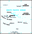
Location: Oceania, archipelagoes in the South Pacific Ocean, about one-half of the way from South America to Australia
Geographic coordinates: 15 00 S, 140 00 W
Map references: Oceania
Area: Total: 4,167 sq km (118 islands and atolls) land: 3,660 sq km water: 507 sq km
Area - comparative: Slightly less than one-third the size of Connecticut
Land boundaries: 0 km
Coastline: 2,525 km
Maritime claims: Territorial sea: 12 nm exclusive economic zone: 200 nm
Climate: Tropical, but moderate
Terrain: Mixture of rugged high islands and low islands with reefs
Elevation extremes: Lowest point: Pacific Ocean 0 m highest point: Mont Orohena 2,241 m
Natural resources: Timber, fish, cobalt, hydropower
Land use: Arable land: 0.82% permanent crops: 5.46% other: 93.72% (2001)
Irrigated land: NA sq km
Natural hazards: Occasional cyclonic storms in January
Environment - current issues: NA
Environment - international agreements:
Geography - note: Includes five archipelagoes (4 volcanic, 1 coral); Makatea in French Polynesia is one of the three great phosphate rock islands in the Pacific Ocean - the others are Banaba (Ocean Island) in Kiribati and Nauru
Advertisement
The information here has been derived from Public Domain Sources such as the CIA World Factbook. No liability can be taken for any inaccuracies.
Tot: 0.021s; Tpl: 0.007s; cc: 3; qc: 2; dbt: 0.0046s; 1; m:domysql w:travelblog (10.17.0.13); sld: 1;
; mem: 1mb
 The French annexed various Polynesian island groups during the 19th century. In September 1995, France stirred up widespread protests by resuming nuclear testing on the Mururoa atoll after a three-year moratorium. The tests were suspended in January ...