Advertisement
Published: March 15th 2010

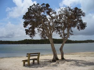
 Bremer Bay
the quiet atmosphere of the estuaryBOUND FOR SOUTH AUSTRALIA
At the risk of boring you all rigid, this blog contains yet more photos of impossibly beautiful beaches with white sand, turquoise sea and stunning coastal backdrops. The southern edge of Western Australia is crammed with beauty spots to make up for the huge expanse of desert on the inside.
Our last entry had us scaling granite outcrops in the Porongurup Range. Impressed with our new found mountaineering prowess, we were inspired to tackle the more challenging Stirling Range - an anomaly of verticularity in an expanse of the horizontal. We conquered Bluff Knoll - nearly 1100 metres and the highest or second highest mountain in WA or Australia, depending on which tourist brochure you read.
At the end of the school holidays the coast was now clear to go back to the coast.
We’d been told about Bremer Bay 60km off the main highway and it’s a real gem - a small holiday fishing village with an impressive collection of beaches of various sizes and orientation to suit everyone from surfers to loafers. The kind of place you’d go back to in ten years to find it full of

 One more mountain to climb
Preparing to climb the rather daunting Bluff Knoll in the Stirling Range, WAtrendy holiday homes and jet skiers.
Next stop Esperance - voted best destination in WA and second best town in the country by Australian Traveller magazine last year - would it live up to expectations?
We drove in through the usual non-descript light industrial area, past a huge fresh fish retailer - this looks promising...then there it is - the aquamarine southern ocean, a long line of Norfolk pines, curving jetty and row of granite domed islands dotting the horizon.
Even an iron ore port at the end of the bay can’t spoil the appeal of this seaside mecca, and there are even more stunning beaches either side of Esperance Bay. The Great Ocean Drive west of town provides vistas of beach after beautiful beach, reaching a climax at Twilight beach, voted Australia’s best.
A 60km drive east brings you to Cape Le Grand National Park, home of Lucky Bay where the photogenic kangaroos come down to the beach to feed on seagrass and lie languorously on the sand.
We walked some of the best coastal walks we’ve found, had coffee at the pier watching Sammy the sea lion beg for

 The brave mountaineers
at the summit of Bluff Knollfish scraps, climbed Frenchman Peak in Cape Le Grand (I even found a Frenchman up there!) and had excellent happy hours with fellow travellers we’ve met on the way.
But there was a part of WA we needed to visit before we could say farewell to the “greatest” state.
Western Australia gets its wealth from holes in the ground and we wanted to see its biggest gold mine and one of the biggest working open cast mines in the world - the Kalgoorlie Super Pit.
As well as being a continuing source of wealth from gold, Kalgoorlie has retained its reputation as a wild west town, with legalised (and tourism promoted) brothels and “skimpy bars” where the barmaids serve your icy beer in their underwear - Rhys assures me this is to further cool the hot and dusty mine workers, but if the advertising is anything to go by, I think the end result is the opposite.
A motley crew of grey nomads, 2 kiwis, 2 poms & 2 Aussies, went on a Friday night pub crawl - the men hopeful of a friendly display of youthful female bounties, the women less

 On the way down
it was a real mountain you know!to keep their men in line, more to laugh at their potential for hopeless inadequacy.
The mean streets of Kalgoorlie were well and truly trawled and liquid refreshments were consumed, but the sum total of skimpiness was one skinny barmaid in a boob tube and two slappers in undies at a back bar the boys didn’t find till they’d got their beers.
By the time the bars start to heat up it’s past grey nomads’ bedtimes and we’re tucked up tight in our caravans - sweet dreams boys!
Kalgoorlie was hot though - 40 degrees with the wind from the desert, not the cooling ocean.
We drove out to Lake Ballard without any expectation of a water-borne breeze - the lake is one of many salt lakes which rarely see moisture and instead gleam stark white with a thick salt crust. Our day trip was to experience an art exhibition of a peculiarly Western Australian nature.
British sculptor Antony Gormley (UK’s Angel of the North) has placed 51 cast carbonised metal sculptures of indigenous locals around 10 square kilometres of the lake. They stand alone but united in their sense
of place and being of the earth.
Unwilling to walk too far on the salty crust of the lake in 40 plus degrees, we only saw about 20 - some far in the distance shimmering in the mirage, or seeming to walk out of non-existent water towards us.
We were the only people there, the silence and expanse of the desert landscape was disconcerting, the brilliance of Gormley’s concept adding to the surreal experience.
If you are anywhere near Kalgoorlie, the 130km trip - even the 51km of gravel - is definitely worth it. Just take lots of water and fly nets!
For the nearly 18 months we’ve travelled round this great land, we’ve read and heard that the best way to cross the Nullarbor Plain is from west to east. This was one of the reasons we decided to go west from Darwin. It’s one of the topics for traveller’s happy hour.
Not that it makes the journey any more interesting - Nullarbor is not an aboriginal word, but a literal Latin translation meaning no trees.
The received wisdom is that prevailing winds are from the west

 Bandicoot road sign, Mt Barker
...and we didn't see any of these either, sighand to drive into a headwind will increase your fuel consumption to mortgage levels.
We were prepared to wait for favourable winds, but a pattern of easterlies had prevailed for weeks so we bit the bullet and headed east, bound, as the song goes, for South Australia.
We were nearly half way across the not completely treeless, but decidedly featureless limestone plain at some godforsaken roadhouse booking in for the night after a day of having the van buffeted by blustery south easterlies straight off the Antarctic ice floes, when the gleeful receptionist informed us that there are no ‘prevailing’ winds - the wind does what it wants and can blow from all directions in one day.
There’s also an advantage for those travelling east to west - we found little information in WA about stops along the Nullarbor and nothing about South Australia, while information centres in SA have plenty of info to help you plan your trip across, and about WA as well.
It may be there are just more people in the east, so there will always be more on the road from that direction. It may also be that

 Fitzgerald River National Park
our picnic spot looking out over Point Ann beachWestern Australia cares so little for the rest of the country that Australia could split in half down the dotted line of their border and they would happily float away - there are many Western Australians who think the state should become independent.
They’re convinced their mineral wealth will ensure their survival - which is why of course the rest of Australia will never let it happen.
The road from Norseman WA to Ceduna in South Australia, 1200 km across the Nullarbor Plain, is the only road you can take between WA to the rest of Australia, unless you go over the top via Northern Territory, or through the middle to Alice Springs on the unsealed and unreliable Great Central.
It includes the longest stretch of straight road in the country - 146.6km through grey-green scrub. The only civilisation is road houses, at approximately 200km intervals - and for these the word civilisation should be taken advisedly.
But as with that other great road trip, the Stuart Highway, there is beauty in the vast expanses of apparent wilderness and the revelation of physical features such as views at Madura Pass, Bunda Cliffs

 Rabbit proof fence
Once over 3000km long, now derelict in Fitzgerald Nat Park - you can't keep those wascally wabbits out!and the Head of Bight.
There is much discussion amongst travellers on how long to take. Some try to do it in as short a time as possible, risking driving off the road with boredom or being attacked by giant hairy nosed wombats and marauding herds of rogue camels at dusk and dawn.
We took four days, stopping at three roadhouses including Eucla in the middle, where it’s worth spending a relaxing afternoon wandering down to view the remains of the original settlement including the stone telegraph station which is now being swamped by the unstoppable march of sand dunes, moving inland at the rate of 11 metres a year.
Apart from the headwind it wasn’t the scary road trip some predict - although going through two time zones created minor jet lag.
Our saviour again was the iPod, courtesy of Arts Waikato, eclectic music courtesy McNair and Ricky Gervais audiobooks courtesy of Bill...(those travelling the other way may have been worried that the two old people towing the big van had lost their minds as we drove along hooting with laughter).
Now we are in Port Lincoln, South Australia, about

 Bremer Bay campsite
We had the piazza site - with pink and grey tiles - very luxurious!to explore another state that we know little about except where the wine regions are - dam there goes the budget again!
Advertisement
Tot: 0.217s; Tpl: 0.014s; cc: 12; qc: 58; dbt: 0.127s; 1; m:domysql w:travelblog (10.17.0.13); sld: 1;
; mem: 1.2mb


Alan
non-member comment
Hi
This is a very interesting blog and so i like to visit your blog again and again. Keep it up. Alan http://holidaydestinationinindia.blogspot.com