Advertisement

 The beginning of the trail
At minus one degree celsius, it was a cold start to the 54 kilometre walk ahead of us.The Yurrrebilla Trail connects parks in the Adelaide Hills with each other, starting at Belair railway station and finishing at the Torrens river 54 kms away. It passes through 5 major National & Conservation Parks in the Adelaide Hills and is very popular with locals and visitors who enjoy fantastic scenery, wildlife and sometimes vigorous exercise.
The whole trail passes through Belair National Park, Cleland Wildlife/Conservation Park, Horsnell Gully Conservation Park, Morialta Conservation Park and finally Black Hill Conservation Park.
Most of the trail is located within a few kilometres of the city of Adelaide and many people choose to walk the trail in sections of which there are four.
We chose to complete the whole Yurrebilla Trail in 2 days in the middle of winter 2007. We also used our "little" walk to raise some much needed funds for the Down Syndrome Society SA. Our objective was to be sponsored at the rate of 10 cents a kilometre and we were delighted to raise some $1300 for the Society.
We began our journey with a friend dropping us off at the Belair Caravan Park, the southern end of the trail, where we

 Icy Grass
Just after sunrise in Brownhill Creek Recreation Park.stayed the night in one of their cabins.
This was unfortunately one of the coldest nights for Adelaide for some time and in the morning at 6am, we set off when the temperature was -1c. It was so cold, we crunched through the icy grass for the first hour or so until the sun came up.
The first section of the walk is through the Belair National Park which is relatively easy going. After passing through Echo Tunnel the track narrows and climbs steeply before decending into Brownhill Creek Recreation Park. This is easy walking along a sealed road for about a kilometre before again a short but steep climb up the Peter Nelson Walking track. Near the top of the hill, you can catch a glimpse of the roofline of Carrick Hill, a beautiful home built in the 1930's and houses many 16th, 17th and 18th century fittings, furniture and artwork.
It's now 8.30am and we have covered 10 kilometres. The sun has risen to create a lovely clear but cold day winters day. We are carrying full packs including tent, food and clothing, so you don't feel the cold as one might

 Early morning view of Adelaide
Looking north towards Adelaide cityexpect.
This section of the track continues to climb along narrow and at times, uneven surfaces until you reach the old main road from Adelaide to Melbourne. When you reach the now closed "Eagle on the Hill Hotel", you have completed section one of the Yurrebilla Trail and descend towards Cleland conservation park crossing the very popular Waterfall Gully Trail which climbs to the Mount Lofty Summit.
We finally arrive at our lunch spot destination, the Cleland Park Visitors Centre at 1pm for a short rest and much needed cup of coffee. We have now walked for 7 hours and covered almost 20 kilometres.
After a half hour R & R break we set of for the last 10 kilometres of day one's walk. We had to cover 30 kilometres in our first day to reach our overnight camp site deep in one of the valleys. We have never completed this trail before and weren't sure how long it would take, however we knew we had to be at the campsite by dark which was around 4.30 - 5.00pm.
The track from Cleland is mostly along 'fire tracks' used as access for

 10 kilometres down - only 44 to go.
Narrow winding section of the trail.fire fighters during the bush fire season. The walking here is relatively easy although there are a few steep sections. In this section of the trail, we also walk along some sealed roads making it easy going and enable us to cover the kilometres a little quicker. We have arrived at Coach Road now after walking some 26 kilomtres and heading down hill to Horsnell Gully, our end of day one destination.
The down hill track into Horsnell Gully is initially along fire tracks again before returning to narrow and in parts rough uneven paths. It's approaching 4pm and the light is starting to fade quickly. We pass some old ruins of cottages built in the 1800's and now, in part, being restored. We eventually reach the bottom of the gully and cross the creek before walking the last 1/2 kilometre of the day to our overnight stop.
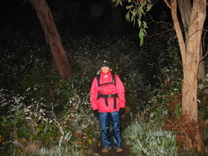
By the time we reached our overnight stop, it was 4.30pm and dark. We pitched the tent in the dark made some dinner, a superb culinary delight consisting of steak and onions (canned and cold), bread, dried biscuits and water. Yum! After eating our restaurant quality meal we

 There's a Bear up there!
"Can't a Bear get some sleep around here"crawled into our sleeping bags and slept (very well too). It's been a long time since we went to bed at 6.30pm, but the night time entertainment in the deep dark crevices of the Adelaide Hills was limited to the occasional sound of a distant motor car or the consistent grumbling of an " I'm looking for a mate" Koala Bear in the tree, directly above our camp site. Needless to say, we slept well until about 5.30am when our Koala friend must have finally attracted a mate and they were really making some noise by now. We got up, had some breakfast, packed our clothes, tent etc and set of just before 7am. We were lucky today, as the weather had warmed considerably to 1 degree by the time we got going.
Again it was dark when we started our 2nd and final day's walk. Today, we had to cover the final 24 kilometres to reach our final destination, the River Torrens. The morning started with a fairly steep walk out of Horsnell Gully and as well as being still dark it was raining lightly for a short while. After a non stop climb of two

 End of Section, beginning of Section 2
17 1/2 kilometres from the start, we begin Section 2 heading towards Cleland Conservation Park and a half kilomtres, we reached Lobethal Road where we turned left and followed it to the neat little township of Norton Summit. We originally thought we would reach the Norton Summit Hotel at around 9am, just in time for a hot breakfast and cup of coffee, however we were well ahead of time getting there just on 8am. Didn't think they would welcome us knocking on the door asking for breakfast, so we had a short break and continued along Colonial Drive before turning off into the Morialta Conservation Park.
Morialta Conservation Park is unique in so much that it has numerous walking trails, some quite gentle and others quite demanding, it also has some spectacular rock formations and three very attractive waterfalls. We entered the park from the eastern side and walked westerly along a small creek bed until we reached the third falls. Most the year there is always some water cascading down the falls, through a lovely creek bed for a kilometre or so to the second falls. These are higher and surrounded with some great viewing spots. We pass the second falls and eventually the first and tallest of the water falls on

 Lunch Stop
After 7 hours walking, we stopped at Cleland Conservation Park Visitor Centre for a short rest, bite to eat and a much needed hot coffee.our way to the Deep Creek Lookout. From here you get a superb view of the Morialta Gorge and the Giants Cave located near the floor of the gorge. We have now covered about 39 kilometres of the 54 kilometre walk as we head north along the narrow path up to the highest point of Morialta Park. Along this path, you enjoy spectacular views of the north and north western suburbs of Adelaide as well as a great view of the coast. When we arrive at the high point at Moores Road, we turn left and head down the next valley past Fox Hill Dam to Montacute Road.
Here we leave the park and walk along Montacute Road for a couple of kilometres where we leave the road and head up Quarry Track on our way the Black Hill Conservation Park. This track is very steep in sections and after walking some 17 kilometres so far today, it takes a lot of effort to reach the top. At one particular part of the track after a non stop climb, you reach a corner when you expect, hope or pray for a flat section, you are confronted with perhaps

 Rough Track
Rough section of the track leading to the bottom of Horsnell Gullythe steepest part of the whole 54 kilometre trail. You turn the corner, look up at what lay ahead and utter the words "oh #@*! no". So we named that corner "oh .#@*!. no corner". We've since been up there again and while it is very steep, it's maybe not as bad as it was the first time when we had already walked 20 odd kilometres with full packs.
Eventually we reach the top of the hill and walked along the ridge. This is an easy walk now as we pass the 50.5 kilometre post along the Sugar Loaves Track and finally we turn onto Ambers Gully track for the downhill walk to the end of the trail. As we descend, the weather begins to change from slightly overcast to light rain. Nearing the bottom of the downhill section we pass the Tufa 'waterfall' at the 52.5 kilometre mark. The 'waterfall' is ancient quartzite which has formed a cliff across the gorge. We pass Ambers Ruin, a two roomed shepherds hut built in the mid 1800's, to our left and walk the final 500 metres to the end of the Yurrebilla Trail.
We finished the days

 Camp Site
We had walked 30 kilometres to reach our camp site on day one. While it was only 5pm, it was already dark.walk at 3.20pm on the Sunday which was ahead of time. Overall, we walked for 18 1/2 hours to complete the trail. This was our first medium length walk and we learnt quite a lot about our local parks (fantastic), our fitness (happy) and equipment (still learning). Most of all, we gained a wonderfull appreciation of the amazing walking trails all free of charge and all within a couple of kilometres of Adelaide.
In the middle of winter, yes it is cold, but the air is crisp and clean and the sighting of kangaroos, koala bears, birds and various fauna makes it all worthwhile.
Advertisement
Tot: 0.077s; Tpl: 0.014s; cc: 8; qc: 49; dbt: 0.0404s; 1; m:domysql w:travelblog (10.17.0.13); sld: 1;
; mem: 1.2mb


Pam
non-member comment
Walking is good for you
I remember my baby brother years ago struggling to complete a walk in the Flinders Ranges. This site reminded me of that holiday. It was the last one we ever had together. Beaut pictures, congratulations.