Advertisement
Published: July 23rd 2009

 The Western Most Highway in North America
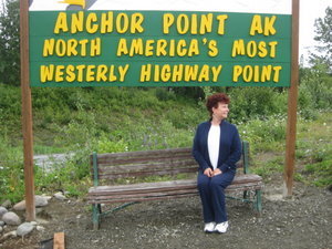
North America's Most Westerly Highway Point ! Do you know the Northern most state in the USA? It is Alaska.
The Eastern most state and the western most state? Alaska. Think about it.Ninilchik was settled by the Russian Orthodox at the turn of the 19th century and is recognized by the old green and white Russian Orthodox church on the hill overlooking the Cook Inlet. This village is built around the fishing industry although most of the villagers now are fishing the Kenai River in Soldotna and Coopers Landing for salmon. The salmon have moved from this area in the inlet upstream to the Kenai. Halibut charters are abundant here with some 287 operating from Ninilchik, Anchor Point and Homer.
Anchor Point was originally named "Laida" by Captain James Cook in the summer of 1778, when the "Resolution" and the "Discovery" sailed into Cook Inlet looking for the Northwest Passage. It was later renamed Anchor Point by early homesteaders to commemorate the loss of an anchor off the point by Captain Cook. A post office was established here in 1949. Anchor Point is noted for its excellent seasonal king and silver salmon, steelhead and rainbow trout fishing along the Anchor River. The salmon have left this area now and are in the Kenai River so everyone from here is fishing the Kenai for Salmon unless they go 17 miles out to sea
and fish for Halibut. North America's most westerly highway point is located at Anchor Point.
Homer was established on the north shore of Kachemak Bay at Homer Spit in 1895. A post office was established here in 1896. Kachemak, the Russian name for the bay means "high cliffs above the water". Another interpretation of the name suggests it means "smoky bay" and is derived from the smoke which once rose from the smoldering coal seams jutting from the clay bluffs of the upper north shore of Kachemak Bay and the cliffs at Anchor Point. In the early days many of the exposed coal seams were slowly burning from causes unknown. Today the erosion of these bluffs drops huge fragments of lignite and bituminous coal on the beaches. In the long winter months, many residents would collect the coal on the beaches to use for warmth. There are over 400,000,000 tons of coal deposit in the immediate vicinity of Homer. Coal mining ceased to operate around around the time of WWI.
A coal mine operated here in the late 1800's and a railroad carried coal out to the end of the Homer Spit. The railroad was abandoned in 1907.

 Captain Pattie's Restaurant
Fish, Fish, Fish .........any kind , cooked anyway you like ! Oysters, crab, salmon, halibut, trout, clams, you name it, they have it !The Homer Spit is a 4.3 mile long piece of land that jutts out into the Cook Inlet and Kachemak Bay. It is made of gravel and coal and it is covered with small fishing charters, restaurants and souvenir shops. Settlers continue to trickle into the area and fishing is the largest industry in the area now.
Advertisement
Tot: 0.172s; Tpl: 0.01s; cc: 6; qc: 50; dbt: 0.0852s; 1; m:domysql w:travelblog (10.17.0.13); sld: 1;
; mem: 1.1mb

 The Western Most Highway in North America
 Captain Pattie's Restaurant
