Advertisement
Published: August 1st 2009

 The Kenai Fjords National Park
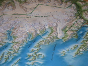
This National Park covers many many miles of ice fields, glaciers, forest, valleys and cities.The Seward Highway is spectacular with views of the mountains, the Kenai Fjords, glaciers and wildlife. Most of the trip takes you through the Chugach National Forest where waterfalls, rivers, and lakes surrounded by beautiful mountains is the perfect place for viewing moose, bears, eagles and other wildlife. You can take a river float trip on the Resurrection River, or a ranger narrated cruise in the Kenai Fjords National Park. Seward is a coastal town and was founded in 1903 and named after William Seward, who bought Alaska from the Russians in 1867.
During the Alaska gold rush, Seward was the start of the Iditerod trail, which led to northern gold fields. The Iditerod is a National Historic Trail and had it's beginnings as a mail and supply route from the coastal towns of Seward and Knik to the interior mining camps and beyond to the west coast communities. Mail and supplies went in and gold came out .........all via dogsled. The trail was used until 1924 for carrying mail until it was replaced by the airplane. The Iditerod trail sled dog race now runs from Anchorage to Nome, some 1049 miles and usually takes 9-1/2 days to complete. The

 Ray's Restaurant
This is a wonderful restaurant on the warf at the Seward Marina.race began in March of 1973 and it is still going on today. It is still affectionately known as "The last great race on earth".
We visited the Kenai Fjords National Park and walked to one of the many glaciers in the park. What is a Fjord? A fjord is an inlet of the sea, or a narrow bay, extending far inland between steep walls of solid rock. Fjords usually have branches that jut from the main body of water. The walls of the fjord extend deep below the surface of the water. Most geologists believe that fjords were formed when glaciers carved deep grooves in the coastline. Later, these grooves filled with water and snow as the sea level rose.
Exit Glacier and the Harding Ice Fields takes about 1/2 day to visit and walk to the edge of the glacier and the ice fields. Exit Glacier has retreated 50 feet a year in the last 200 years. As you approach the glacier, you'll see markers starting in 1790, and ending in 1998, that show the dramatic rate of the ice's retreat. The Nature Center at the beginning of the trail to Exit Glacier explains the area.

 The Seward Marina
Outside Ray's Restaurant you can view the Seward Marina. Notice the mountain tops above the clouds, giving an eery feeling to the surroundings below.The mountains that dominate the southeastern half of the Kenai Peninsula contain a massive ice field that fills the mountain valleys over an area 50 by 30 miles. The Harding Icefield is a relic of the Ice Age. Bounded by high mountains, the ice field is only accessible from the road at Exit Glacier. Glaciers carved the deep fjords that are the basis of this national park, which was created in 1980. It is about a 3 mile roundtrip hike uphill to the ice fields and the glacier. The trail is well marked and very enjoyable to hike. Be sure to take the ranger led cruise into the bay and visit the Aialik and Northwestern Glaciers. The Kenai Fjord National Park covers some 600,000 acres.
As we were leaving the Exit Glacier, we noticed water at the highway level. This was around 4 p.m. We commented that it appeared the river was rising quite rapidly. That evening, the river flooded the road, washed out part of the highway, and the road and the Exit Glacier Park were closed to the public until the road could be repaired and the water level receded.
While in Seward be sure

 Baleen
Many restaurants here in Alaska are decorated with Baleen. Baleen is a hard horny substance that grows in long plates in the upper jaws of toothless whales. The plates range from .6 ft. to over 12 ft. in length and grow down in rows from the gums of the upper jaw on either side of the mouth. Consisting of a strong, elastic protein called keratin, the material of human hair and fingernails, baleen constantly breaks but continues to grow throughout the whale's lifetime. The main function of baleen is to filter food. Gray whales have about 130 to 180 baleen plates on either side of the jaw. Some whales have 230 to 360 plates on either side of the jaw. Until the 19th century, whale baleen was widely used for combs and for stiffening in corsets.to visit the museum, the glaciers, Kenai Fjords National Park, the attractions in the area and have lunch at Ray's overlooking the waterfront and marina.
Advertisement
Tot: 0.262s; Tpl: 0.014s; cc: 6; qc: 51; dbt: 0.1432s; 1; m:domysql w:travelblog (10.17.0.13); sld: 1;
; mem: 1.1mb

 The Kenai Fjords National Park
 Ray's Restaurant
 The Seward Marina
 Baleen


