Advertisement
Published: August 21st 2006

 Sub-Alpine Meadow
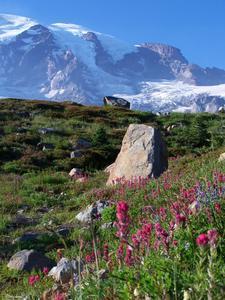
Near Paradise with Mount Rainier in the background.What a day this was. Out of bed at 6am, I started driving towards Mount Rainier. Mount Rainier, on a clear day, is visible from Seattle even though it is 54 miles southeast of the city. This day was clear blue skies all the way (sunset to sundown) and around 80 degrees.
By the way, Mount Rainier is a stratovolcano which has the highest peak (14,111 feet) in the Cascade Range (http://en.wikipedia.org/wiki/Mount_Ranier).
The first and closest place to go was Carbon River, which flows out of Carbon Glacier (the largest, by volume, glacier in the U.S.) and through the Carbon Rain Forest (another temperate rainforest and the only inland rainforest in the 48 lower states). This time no paddling, only hiking.
On the drive down, I made a short stop at a Wal-Mart in Federal Way to pick up some essentials (survival kit, pocket knife, compass, etc.).
Once I made it to the Ranger station, I bought a day pass for me and my car and then hiked the short Rain Forest Loop Trail (0.25 miles... the beginning of the appx. 11 total miles I hiked for the day), which is a cool trail through, um, the
rain forest and it, well, goes in a loop. 😊 Anyway, it was great.
One of the great things hiking through around the Carbon Rain Forest, and other low lying areas around the river, was the soft earth that had a low thumpy sound as each foot hit the ground. The soil looks like it is made up of pine needles and organic matter that have built up over time and it feels soft to hike on.
After that I drove up to Isput Creek Campground to hike the Carbon Glacier Trail (6 miles round trip, 1200' elevation gain, and the first of two major hikes for the day). It started out in the low forest area and followed the river up to the glacier. The river itself twisted and turned rapidly through a mostly exposed pebbled/rocky river bed which appears to be 1/6 of a mile across at some pionts.
The trail went through forest and along the river bed... across small streams and over a suspension bridge. Walking through the forest alone, I remembered the information on bears in the national park that I had read on the Internet the night before. Basically, the national

 Duckie, Paddington, and Avis
On top of a boulder in the sub-alpine meadows with Mount Rainier in the background.park recommends against hiking *alone* for numerous reasons, bears being one of them. Granted, I think the threat is very low since even spotting a bear is slim and they are more likely to run away if they know I'm around than to attack. But I did take some precautions such as talking and clapping periodically (apparently, bears don't like being scared, so it is good to let them know I am nearby).
And, you know, hiking in the wild alone is always kind of unnerving for me. I pray a lot and ponder life and its fragility. I lose the dependence on law enforcement, community, and familiarity to keep me "safe". As the day went on, there were more people on the trails.
When I got to the glacier I was surprised to see that it was very dark and shiny. I expected a kind of bright white/blue ice jutting down from the valley. But with all of the melting at its terminus, the glacial sand (I think that is what it is called), and rock discolored it. At the base of it was a cave which water was flowing out of... the beginning of the Carbon

 Narada Falls - 1
This sign was no joke (and funny at the same time :). The seriousness was that if someone climbed in the stream and slipped at this point, the current would probably push him/her the next 20 yards to a 240 foot drop and almost certain death.River.
After a snack, water, and rest, I headed back down the trail, taking a slightly different route which went through more old-growth forest... huge cedar and pine trees, ferns, moss, and more spongy ground. At some points, the foliage had closed in on almost all of the trail. And, for this 1.1 mile stretch, I didn't see anyone else.
One part of the trail wound underneath a large fallen tree twice... and I didn't have to duck... that is how big the tree was. Many of the smaller "bridges" were fallen trees that the park had leveled the top part off to make it flat and stable to walk across.
I also crossed the Carbon river bed. Lots of logs, pebbles/rocks, and sand. The "bridge" across the river was two logs end-to-end with a pile of rocks supporting the middle. The rushing water didn't look like anything I would want to fall into. In the middle of the river bed, I saw numerous places where pebbles had been stacked on top of eachother. It looked like some way to mark the moment, so I carefully stacked a few pebbles on top of eachother, too.
I

 Carbon Glacier Trail - 6
The Carbon River, the Carbon Glacier, and the snow-covered peak of Mount Rainier. :)then continued on down the trail and, after making it back to the car, I started the drive to Paradise. On the way, I stopped in Carbonado (http://en.wikipedia.org/wiki/Carbonado%2C_Washington) for lunch at the Carbonado Saloon (which was established in the late 1800s). It felt more like a roadhouse bar and most of the patrons had abundant tattoos and drove trucks. I felt out of place. But, I had a great NY steak before heading on my way.
Paradise is located on the southern side of Mount Rainier. People have been camping at Paradise for well over 100 years. It is probably the most popular place to visit at Mount Rainier National Park because of its stunning views of the mountain and its sub-alpine meadows. It is also the starting point for most ascents to the peak of the mountain (which is apparently not an easy task and many, even experienced, climbers have died trying it).
After stopping at a few scenic spots along the road, visiting Narada Falls, and stopping at the Paradise visitor center to pick up a trail map, I took the Deadhorse Creek Trail up to Panoramic Point (a 1400' ascent).
Probably 3/4ths of the

 Narada Falls - 2
Notice the bridge at the top for perspective.trail winds through wonderful subalpine meadows full of wildlflowers, wildlife, trees, and other plants. The views were breathtaking and unlike anything I have seen before. Also, the air was full of various scents from the flowers and trees and it seemed everything was in bloom... probably because the growing season is there is about three months... a short time for many of the plants to spring up out of the ground, pollinate, produce seed, etc.
Much of the wildlife encountered along the way was almost indifferent to the presence of humans. Granted, they took notice and I couldn't go up to pet them, but they seemed okay with me being 5 to 10 feet way. Along the way I saw numerous marmot (http://en.wikipedia.org/wiki/Marmot), which use high-pitched whistle noises to communicate. One of the guys along the trail mentioned this to me when I was asking about what they were. At one point, I passed a mother marmot two of her young. She looked at me for a little bit and then let out a loud, crisp whistle... so loud it slightly startled me. Immediatly, one of her young (the one closest to me) went straight into their hole by

 Paradise - 1
Does this place rock or what? I want to have a family picnic here one day. It was kind of surreal.the path. I walked up the hole and the little marmot walked out and looked at me and I said hello. The mother just kept eating the wildflowers and seemed indifferent to my presence after that.
I also passed by (about 70 yards away) a white mountain goat (http://www.nps.gov/mora/notes/vol2a-14a.htm)(http://www.mount.rainier.national-park.com/info.htm). It was lying down on a big patch of snow and appeared content with life. I like the way mountain goats are unafraid of the cliffs... climbing the mountain... living in one of the most challenging habitable environments on earth -- read the linked article above and I think you'll understand.
Also along the way was a little bird, a deer with her two fawns, and numerous chipmunks.
The trail wound up to apline meadows (which are more sparse and rocky than the sub-alpine meadows). The plants at that elevation depend on the rocks for protection from wind and ice. All the meadows are fragile, and all visitors are supposed to stay the rock-lined trails (though some people don't... and by straying from the path they destroy areas of the meadows). At one point, I yelled at some foreign guy that was climbing up a little cliff right

 Paradise - 5
Along the path.off the path... I wasn't a little angry, surprised, and thought him and his group were being inconsiderate... they were also throwing rocks down the cliffs... and, it may not seem like such a big deal, but if and when you see the beauty of the meadows, as well as the fragility of them, I think you'll understand. During my hike, I felt like I was looking at a national treasure.
So, I made my way up to the highest point that I could... passing various little streams and piles of snow... and overlooked the Cascade Mountains at dusk. I sat there for awhile, stacked some rocks on top of eachother, and made my way back down the Skyline Trail as the sun set into the horizon. I made it back to the parking lot and then drove back to Seattle.
It was an awesome day, and I recommend that anyone near Mount Rainier during this time of the year check out the park. It is beautiful. And there are so many things that I missed and I hope to visit again in the future... maybe camping for a few days with family and/or friends. I didn't see

 Paradise - 7
Overlooking the Cascade Range. Notice my little stack of rocks on the boulder and some of the other people's in the background.any of the lakes, either. So there is a lot more to the park.
Advertisement
Tot: 0.068s; Tpl: 0.016s; cc: 14; qc: 23; dbt: 0.0352s; 1; m:domysql w:travelblog (10.17.0.13); sld: 1;
; mem: 1.1mb


anonymous
non-member comment
More awesome photos! They really make me want to go to the park and hike to see the views first hand!