Advertisement

 DSCF9016
view of the pioneer areaMileage 260 miles
Oh
, what a night! First off, the refrigerator cycled on-and-off making a loud annoying buzz, then the air conditioner turned on-and-off with its loud whooshing sound. When it was on, it was cold; when it was off, it was hot. Everyone hurt in one way or another, so we had the hotel’s little, tiny pillows stuck everywhere trying to ease the pains. In addition, there were tour groups surrounding us on all sides in our western motel style hotel building (top, sides, and back). Through the thin walls, we could hear every time they got up, used the bathroom, showered, talked, etc. It sounded like they were throwing pianos around upstairs. Couple all of this with the fact that all of us have eaten something in the last few days that had us running back-and-forth to the bathroom. It’s a wonder we got any sleep at all. What little we did we coined “distracted sleeping”.
From Bryce Canyon we headed down, down, down to the tropics; no, actually the town of “Tropic”. It must have felt like the tropics
to the people living on top of that brutally cold mountain. Taking “Cottonwood Canyon Road” to what we thought was the road to the Escalante Staircase Visitor Center, before losing GPS we realized it was a short-cut to where we were going and thought we might take it anyway. We drove through a sharp curve between tight, towering rocks on the narrow road to be met with an immediate sharp curve that drops off into the canyon. Susan barely kept us from doing a “Thelma and Louise”. We saw a caution sign with a cow that had been shot/scratched so that it was a black cow with white spots. Susan said it was a “negative cow” like in photography since we were nearing Kodachrome Park. We kept our eyes peeled for “negative cows”. Eventually, we got to a point where the road became dirt with a giant sign that read “Impassable when it rains or snows”. Without anyway to check the weather forecast, we couldn’t chance going off road. We had to go back.
Back on Scenic Hwy 12 we stopped at the Hole-in-the-Rock” Escalante Heritage Center. This whole area was settled by Mormons who must have

 DSCF9028
our holy lunch breadbeen made of some hardy stock. The “Hole-in-the-Rock” was a pass that they cut into the steep rock straight down into the canyon. They had to use the men and ropes to try to hold back the wagons and horses as they dropped off the side of the canyon into the Colorado River nearly to their deaths. Even Joseph Smith’s wife, Belle, helped to hold their wagon since it was the last wagon in the group. How they made in down the sheer cliffs, we’ll never know.
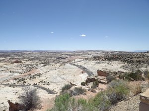
Scenic Hwy 12 was beautiful. The scenery varied as well as the roads. Most of the route was through extremely dry climate with rugged terrain beside the roads whether in the base of the canyons or traversing the steep 8-10% grades up and down the sides of the canyon. Desert, brush, sand dunes, sandstone cliffs, and hard slick rocks filled the scenery in hues of reds, deep oranges, golds, yellows, browns, and grays. At an overlook looking down at the canyon valley below, we decided to pull off and eat lunch – another meal with a view! As we left there we were literally riding on the ridge with drop-offs

 DSCF9029
cliffs on both side of the road. no guardrails. shortly after is when we saw the cow signstraight down both sides (yikes - no shoulder and no guard rails!!!) And, there, on top of this scary ridge, we saw “watch for cows” and “watch for deer” signs!!! What in the world???? Are these “super cows” and “super deer”??? How else could they get to the top of the canyon at top of that ridgeline?? And if you did hit a cow or deer up there, animals would go flying off into the air! The people below in the canyons would see “hamburger” and “venison” coming from heaven!!! (and already ground up at that!!)) We were puzzled . . .
Finally, we arrived at Boulder, Utah and it was GREEN!!!! The only green place we’ve seen in days and we wondered to ourselves, “ Why did they go on to Escalante, Canonville, and Bryce when there was this gorgeous oasis out here in the middle of the desert?” We all agreed that if we had been some of the original settlers, we would have said we were going back to Boulder to where it was green. And, if our husbands were stubborn and wanted to try to set up homes in the middle of the

 DSCF9043
beginning of Capital reef Canyondesert, they could just come visit us whenever they wanted. We’d figure the kids would want to stay with us since we would have been doing all the cooking. Even as we climbed up out of the canyon on Boulder Mt at 9636 ft, there were lush groves of spring green aspens and pines right next to the road. Then we saw a funny sight? Some of the aspens had trouble competing with the pines, so they grew taller than the pines without any leaves until they peaked over the top, then suddenly there was a big “puff” of spring green leaves. Susan said it looked like Christmas trees with bows on top. This whole area was so much greener and nicer than the rest, but, as we went back down the mountain, we met dry land again. If you had to live in the area, why would anyone live anywhere other than that oasis???
Next, we went to a place Susan had heard about called Capital Reef National Park. We were tired and almost didn’t stop, but thankfully we did. It’s a great park. With huge, mostly iron-red rocks in sandstone all around, we drove through

 DSCF9085
driving into the narrowsand hiked out across painted hills with whites, blues, and greens surrounded by slickrock, sharp-edged monoliths towering to the sky. Other parts of the park still look quite canyon-like as eroded mesas. 1
st stop – Gooseneck Trail to 600 ft drop offs where it actually rained a few drops on us. 2
nd stop – All the way at the end of the paved road in the park, we took a 2.5 mile rugged, dirt road that was so bumpy we were getting bounced all over the place and could hear the ice constantly sloshing in the coolers. We took the Capital Gorge/Narrows Trail - near Capital Dome, a white monolith (shaped like the US Capitol building) towering above the other giant rocks. Here we went deep in the canyon floor walking along the dried-up river bed through the narrows to see petroglyphs and other sights. Looking back, we saw dark storm clouds and having already had some rain on us, we decided we should get out of the heck out of dodge and headed back. 3
rd stop – Grand Wash – The road to a hike to “Cassidy Arch”. The road in it runs through the wash between the surrounding
mammoth rocks and is where the whole canyon area washes out. At the start we were met with a sign that read “Warning – Do Not Enter if Threatening a Storm in Area – Flash Floods Happen without warning!!!! Know the Weather and Enter at Your Own Risk!!!” With no internet connection and it storming on the nearby mountains, we decided we weren’t up to risking our lives with Cassidy. No arches for us or Cassidy today! 4
th stop – Visitor Center to pee. Nope, guess not. It’s closed for the day! 5
th stop – Fruita Schoolhouse - An old, one-room schoolhouse built in 1870’s about the size of a small bedroom that was used at one time for around 20 students of all grades. Susan and Pam couldn’t imagine teaching in such a small room for all ages, but they had Claire make our pictures there anyway.
Out of Capital Reef Park, the scenery changed every time we came across a hill in the canyon, colors went from the reds of Capital Reef to golds to grays and from rocky to petrified sands to what looked like moonscape to real sand dunes. And, then out in

 DSCF9143
hiking in the dry river bed into the more narrowthe middle of nowhere with only gray sand as far as the eye can see, there was a sign for “Open Range”. Seriously??? What would a cow have to eat out here??? There’s not even a blade of grass for miles!!! We didn’t see any cows at all. Now that we had driven most of Utah and were staring out at this emptiness, Pam stated, “So much of this state is uninhabited.” Then, Susan corrected her, “So much of this state is uninhabitable!!!” (ha! ha!)
In that uninhabitable stretch we decided to come up with a list of things we learned today:
• We could never have been pioneer people
• How scary and difficult it must have been for the pioneers to get themselves and supplies down into these canyons
• Why you don’t drive in “wash areas”. Who wants to be pounded up against the rocks in raging flash floods from a single rainfall? (See current floods in Maryland)
• Capital Reef was much better than we thought and we recommend it
• From the bumpy roads, we understand why, when they brought milk from Escalante to Boulder in the olden days, it turned to butter.

 DSCF9146
petroglyphIf we would have had milk, sugar, and rock salt, we could have easily made ice cream in our coolers on the bumpy roads!!
• Claire really likes hiking sticks now that she started using them. She can maneuver rocks and is eager once again to try even more serious trails (it’s like she has new legs).
• When you’re driving 20 mph on curvy, steep, bumpy, dirt roads, it’s hard to get anywhere fast.
• Boulder and Boulder Mountain are oases in the desert of Utah
• The difference between a gorge and a canyon: a gorge is narrower like a “V” and a canyon is more straight down making a wide valley.
• Pam told us, If you haven’t turned off the Emergency locator on your phone, it is set so that, even if your phone appears dead, your signal can still be pinged for a couple of days to locate you. (So, keep your phone with you when you go do stupid things like hike in wet and dry rivers)
• Free range cows must be great mountain climbers that eat rocks and sand, because all the free-range areas are on rocky or sandy cliffs.
We stayed at a Holiday Inn

 DSCF9153
view straight upExpress in Green River and we used points.
Advertisement
Tot: 0.19s; Tpl: 0.013s; cc: 13; qc: 44; dbt: 0.0615s; 1; m:domysql w:travelblog (10.17.0.13); sld: 1;
; mem: 1.2mb


