Advertisement
Published: October 15th 2018

 rock climbing
Walters scenic view (with Walter)
stock picI finished with the "Devils Backbone" and arrived in the Town of Escalante. Tonights camp would be Westbound from here; but there was something wonderful Eastbound to experience, so I did a backtrack to see the Escalante River canyon and more.
First I arrived at the big parking area for the scenic overlook on top of the Escalante River valley. I camped downhill from the scenic overlook several times while it was legal camping. I would drive across the levels of the "slick-rock" areas and camp out of sight from the highway. Now most of that highway has guardrails just to keep people off of our public land. That was all BLM free camping until they made the Escalante National Monument (small NPS) and the camping ended. There are no signs to tell you where the NPS is located; and no marked fee areas.
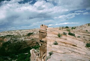
Downhill there is a fair sized parking area on the North side of Utah 12 with a very nice scenic view of the Escalante River Canyon. From the parking area are two very neat colourful rock formations with, by far, the best views. First a smart athletic person with good boots can climb up the

 scenic overlook
Utah 12
Eastboundrock formations. I am neither, but I have good boots. Since I am disabled I can not climb those rock formations. However, I could see natural pathways in that rock that forms a walk-able set of switchbacks up and down the two rock formations. Slowly and carefully I would walk those natural switchbacks up to the top of the first rock formation and shoot the second rock formation. Rarely I would walk up the second rock formation including today. (With the parking area often having multiple cars there for their quick pics; I have never seen anybody else try to climb the rock formations.) Unfortunately I can not find any of my pics from the parking area.
It would take me about thirty minutes to walk up to the top of the two rock formations; but the wonderful views of the Escalante River Canyon make it well worth my time and effort. On my last rock climbing pic the Escalante River is hidden by the rock formation on bottom right. Utah 12 East (on left) goes up the scenic Calf Creek Canyon. Utah 12 West (to the right) will cross the Escalante River and come uphill to the scenic
views.
I drove downhill to the Escalante River and somehow lost the river pics. Then I drove uphill in the very scenic Calf Creek Canyon. This was a narrow winding road with large colourful sandstone of white and pinkish cliffs. There was many places to pull off the road for day use including burning mega-pixels and picnic food and drinks.
Before I got to Boulder I turned around and went back Westbound, cuz I had much to see and do before I would make camp in the high elevation forest of the Dixie National Forest.
completed
Advertisement
Tot: 0.217s; Tpl: 0.016s; cc: 12; qc: 47; dbt: 0.1042s; 1; m:domysql w:travelblog (10.17.0.13); sld: 1;
; mem: 1.1mb

 rock climbing
 scenic overlook
 scenic overlook


