Advertisement
Published: March 7th 2022

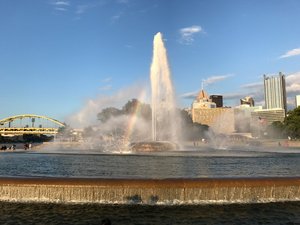
 Point Park Fountain
Point State Park. IMG_1683The confluence of the Allegheny and Monongahela Rivers to form the Ohio River is known as The Point. The Point also known as the Golden Triangle, is the center and origin of Pittsburgh. In the Colonial era, the confluence in the western frontier was known as the Forks of the Ohio. It was a highly contested area during the Colonial era. The British and French vied for control of the Ohio River basin and its connection to the Mississippi, culminating in the French and Indian War (1754-1763). Replacing a frontier trading post, first the French Fort Duquesne (1754) and then the British Fort Pitt (1758) rose at the Forks of the Ohio. Pittsburgh takes its name from fort Pitt, which had been named for William Pitt. The area was heavily industrialized during the 19th century as the city of Pittsburgh grew. Today, the site has been beautifully landscaped as Point State Park. We were here on a spectacular summer evening to take in the history and riverside promenades.
The preserved Fort Pitt Block House was built in 1764 as a small defensive redoubt and is the only surviving structure of Fort Pitt. After 1772, the structure became a trading post

 Fort Pitt Bridge
The Fort Pitt Bridge carries I-279 over the Monongahela River. IMG_1671and then a residence during the 19th century. The Monongahela Bastion of the fort has be reconstructed and houses the Fort Pitt Museum.
The centerpiece of the park is the Point Park Fountain located right at the confluence. The open space of the park is the Great Lawn. The location of Fort Duquesne is marked in outline by a granite tracery within the Great Lawn.
Advertisement
Tot: 0.058s; Tpl: 0.01s; cc: 12; qc: 28; dbt: 0.0322s; 1; m:domysql w:travelblog (10.17.0.13); sld: 1;
; mem: 1.1mb

 Point Park Fountain
 Fort Pitt Bridge


