Advertisement
Published: September 3rd 2009

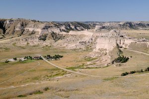
 View from the top of Scott's Bluff
View looks down on the Oregon Trail and the visitor info centerThis was our last day in Nebraska. We had traveled back and forth on many of it's scenic trails during the past few days. We returned to Scott's Bluff National Monument this morning to take the road to the top. It had been closed when we were there last evening. Today's starting temp was 70 F and the skies were absolutely clear blue so the view from the top of the monument was spectacular. I took many photos from the top and at the base of the bluff. As I looked out across the plains and the site of the original Oregon trail below the bluffs I couldn't help but think that the pioneers must have been incredibly tough people.
By noon the temp was up to 82 with a gorgeous breeze. We had lunch in Scott's Bluff because there would be nothing available for the remainder of the afternoon until we reached South Dakota. We then traveled north towards the state line but stopped quite a few times along the way to take photos of things that caught my eye. One was a field of sunflowers. These were not the wild ones that are seen all along the roadside but

 Sunflowers
The heads were all hanging down as is they were embarrassed.the regular single stem tall type that I was used to. Pretty neat !!
The area between Scott's Bluff and the Black Hills of South Dakota was an open prairie land of rolling hills totally devoid of trees or shrubs of any type except for the occasional farm house with a few trees that had obviously been planted for shade and wind protection. Each of the farms had a very typical looking windmill. Other than that, it was open prairie lands with rattlesnakes and prairie dogs. We saw the prairie of course but no rattlers or prairie dogs. The open spaces were beautiful with fesh air, expansive vistas and it was so quiet. As we neared the South Dakota border we passed the Nebraska National Forest and the terrain began to change. The Black Hills of South Dakota lay ahead. Nebraska is truly lovely. We had seen sand dunes, corn and soy fields, cattle ranches, open prairie land, the Oregon Trail, bluffs and buttes, small towns, grasshoppers by the millions and so much clean wide open space.
We were traveling on 385 north when we crossed the state line into South Dakota at 4pm. The temp was 85. By 4:30pm

 Windmill
Each farm had one or more of these. The only source of water out here on the prairiesthe road became very winding and began to climb into the Black Hills and the forest. We passed through a few small towns. Hot Springs was particularly attractive with a river, small waterfall and many building built from red stone. The soil here was very red.
Wind Cave National Park was en route and as we drove through it's very grassy rolling hills we saw Pronghorns and a herd of Buffalo. It was my first time to see a pronghorn in it's natural setting. The park was established in 1903 by President Theodore Roosevelt, it was the seventh U.S. National Park and the first cave to be designated a national park anywhere in the world. The cave is notable for its displays of the calcite formation known as boxwork. Approximately 95 percent of the world's boxwork formations are found in Wind Cave. Wind Cave is also known for its frostwork. The cave is also considered a three-dimensional maze cave, recognized as the densest (most passage volume per mi3) cave system in the world. The cave passed Hölloch cave in Switzerland on February 11, 2006 to become fourth-longest in the world with 119.58 miles (192.45 km) of explored cave passageways. The

 Through the Prairie Lands
Nothing in sight but grassy prairie lands and the long road aheadcave's current length is 131.04 miles (210.89 km), with an average of four new miles of cave being discovered each year. Above ground, the park includes the largest remaining natural mixed-grass prairie in the United States. The park stands at an elevation of just over 5000 feet.
Next came the Blackhills National forest. We were still climbing and the temperature dropped from 85 to 73. What a treat.
The Black Hills are a small, isolated mountain range rising from the Great Plains of North America in western South Dakota and extending into Wyoming. Set off from the main body of the Rocky Mountains, the region is a geological anomaly—accurately described as an "island of trees in a sea of grass". The Black Hills encompass the Black Hills National Forest and are home to the tallest peaks of continental North America east of the Rockies.
The name "Black Hills" is a translation of the Lakota Pahá Sápa and were named because of their appearance from a distance.
We reached Hill City which was our destination for today, and had dinner at a lovely little Inn named the Alpine Inn. They serve only filet mignon priced between $8 and $10 depending on

 Pronghorn
Quick shot taken from the car. the size and they are famous for miles around. The Best Western Hotel in Hill city will be our base for the next 3 days. Tomorrow we will head out to travel some of the scenic routes in this area.
Advertisement
Tot: 0.193s; Tpl: 0.011s; cc: 20; qc: 97; dbt: 0.0967s; 1; m:domysql w:travelblog (10.17.0.13); sld: 1;
; mem: 1.3mb


