Advertisement
Published: August 7th 2010

 Stranded!
A 2-3 planned drive (including hikes) turned into a 7 hour ordeal! From T.R. National Park, Sophie the dog and I jumped on our first major interstate after almost 2000 miles—I-94. After 50 miles, in Glendive, we hit a desolate road, Route 200, which continues westward towards Great Falls. The drive offered astounding views of rolling, wheat-filled plains. I listened to the I-pod, playing more Dylan and Velvet Underground, snapping pictures at random out the window. Our next stop is Glacier National Park, but having not left T.R. National Park until about 4 p.m., we were again driving directly into the sunset. There would be a stop tonight in another National Forest, the Lewis and Clark.
A rare double-rainbow, now a current cyber-hit on YouTube (A hippy-type guy in, I think, Yosemite, gets overly-emotional witnessing this event), offered a chance to do a quick parody video. It was, however, truly spectacular, and lasted for a full 30 minutes, until the sun, an essential element of a rainbow, had started to go down. Having stopped in a huge grocery store to restock on Sophie’s can dog food (her “long-term camping treat,” and, since I
had been out for the last day, she was on a hunger strike), I had for the first time in 2 weeks actual cheese.
A food break at sunset at a rest stop got us both charged up again, and I had a wonder chat with a couple from Wisconsin. The man, Roger, had driven his pick-up truck camper to Alaska, and was heading back. He went all around the huge state, and he said that there were too many people up there. We chatted about Chicago and Wisconsin. On breach of ethics on my part—I had neglected to take Sophie’s dog food can for recycling, leaving it on the sidewalk of the rest stop, not realizing it until I was 30 miles West. Oh well, I’ll up my routine of always picking up trash, luckily small-sized this trip, from the various stops and camps that I’ll make.
It was surely dark and getting late, and I was in a hurry to get into the Lewis and Clark National Forest, as I was exhausted. I missed the left-hand turn-off in Stanford, overshooting it by 10 miles (and adding another 30 excruciating minutes at midnight). It

 Till' the Cows Come...
Oh, wait. There they are.was my goal to camp just inside the National Forest, then, on Molenbrock’s This Land book recommendation, drive up a Forest Service road to Neihart on Route 87. He promised several abandoned gold mine operations, a favorite of mine to view and photograph.
After 20 miles of dirt road, I finally entered the National Forest, again in the total darkness. Tonight’s camp, just 10 yards off the road in a field, had a strange wood structure build from 4-inch pine tree logs. My mind, in its weary state, starting freaking out, recalling several various methods that I would meet my demise on this night: cults, locals on a joy ride running over the tent, or, a new one to the list, the methheads, who would claw through my camping gear searching for anything of value to sell for their habit.
A lone PBR knocked me out rather quickly, and in the morning, we woke to a very pleasant scene (always a bonus to balance out the previous nights’ anxieties). Next to the campsite, across a dry creek bed offered a nice mountain meadow, framed on one side with a fragrant pine forest and a large, rock-faced
wall on the other. Also, there were a number of archery targets, the reason for the mystery structure at the camp (and not a Blair Witch-type scene after all).
Sophie the dog and I hiked around for an hour, coming across a huge valley for cattle. We also took the back face of the rock cliffs, gazing high atop the ridge and viewing the truck and tent far below.
I had a shower and a nice breakfast, leftover rice and boil-in-bag Indian food. Sophie the dog had an entire can of Alpo. Jumping into the truck, we headed further into the forest, snapping pictures of livestock, examining creeks and 100-year-old graves, and filling up all water sources (A 5-gallon collapsible plastic jug, a ½ gallon jug, the solar shower, and 3 water bottles) at a natural spring spigot.
Uphill Battle… The winding dirt road passed through valleys, then started its ascent to the mountaintops, the highest of which is 8,800 feet. Since we had gotten up so early, it was my goal to breeze up the mountain, check out a few gold mines, then read down the north face to the town of Great Falls,
Mont., home of the T.R. National Park Ranger-endorsed Lewis and Clark Interpretive Center. The site also (I thought, as indicated on the road atlas) offered a campground and would serve as my springboard to Glacier National Park.
I was studying the road atlas a fork in the road at 5,000 feet when two National Forest vehicles came barreling down the service road. I stepped out to confirm my direction (there’s usually many other road offerings then just those shown on the road atlas). In the 4-wheel drive vehicle, there were two occupants: A “young buck” passenger, who rattled off directions to reach the gold mines, once I crossed this current peak, and a more subdued, fit man my age driving. He was quieter, and after asking about other mines up there, he said, “You know, the road’s kinda’ rough up there.” Pointing to the Tacoma, I said, “You don’t think this old thing will make it?”
Dramatic pause. Silence. Slight head roll to the left. Then, parting words from him: “Well, good luck.” Then they were off, back down to past where I had camped.
The ol’ truck had been, on last year’s 5-week trip from
Chicago to Utah, excellent on a variety of Forest Service Roads: dirt, washboard dirt, gravel, sand, rocks, etc. I had no reason to doubt her now, even with a large, orange Forest Service sign, stating: This road is not service for vehicle traffic.
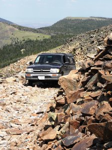
And, no doubt, even though fist-sized rocks now dominated the road’s surface, the truck was doing great. We rose higher and higher in elevation, moving 10 miles an hour and with slow determination. Through forests and past vistas and large boulders, we finally reached the first peak, a moss and flower-covered surface. Then, on the single-lane road, the next mountain presented itself: A large, totally larger-sized rock-covered road that was precariously following an upward slope, large vista on the right. No guard rails, and 1-2 foot boulders to cautiously dodge. I was making slow progress, moving only 1-2 miles an hour in first gear. The muscles in my clutch leg, the left, twitched uncontrollably from such concentrated and intense usage. My fingers gripped the wheel, body hunched forward, and Sophie leaning into me with a force. I dare not look right, as the view was dizzying. Any one of these large bumps and jostles was
enough to crack an oil pan or flatten one or more tires, rendering me stuck.
Then, I met my match—a boulder in the middle of the road that I determined was not passable in my vehicle. Stopping the truck for the 4th time in 40 minutes, I studied and contemplated. I looked at the rock. I looked under the vehicle. I cursed. I looked behind the vehicle at 50 yards of terrain that I had just spent 20 minutes, going forward, to inch up. I stacked rocks (suddenly, now, I’m in road construction). Precariously passing that, shortly up the road was an even more impassible situation.
I was officially stuck—unable to move forwards or backwards.
Why the hell did I not listen (or: hear!) the Forest Service worker?!
I tried to keep a cool head, but was slightly panicked. I tried a bit to move backwards, but it proved to be near-impossible, as without the advantage of seeing the rocks, the back tires would fall into small crevices. I stopped the truck again and cursed some more. Is it possible to even be towed from here? I envisioned providing fodder for countless retellings
of the thick-headed Chicago know-it-all who didn’t head constructive advice.
After an hour of consideration, I determined that my only option was to build enough road to bring me 40 feet back down, where a slight widening of the all-rock road might provide enough space to turn around. The process took another hour.
I toted 40-lb. long, flat rocks, trying to make the unseen passage as smooth as possible. Painstakingly inching my way back, I bounced down to my chosen turn-around spot. About 20 4-inch back and forths did the trick, my adrenaline as high, as I knew that the slightest involuntary push on the gas would send us hurling over the edge, adding a sad ending to potential local lore, becoming a cautionary tale as opposed to a good oral lashing.
I almost cried when I finally got turned around to limp back down the mountains with my tail between my legs. I was well aware that in such instances, the major perceived danger averted, that I was, both literally and symbolically, not out of the woods yet. Too much anxiety to leave the situation could easily lead to, again, truck trouble, most likely a
flat tire (which I was still sure would happen).
After a half hour of slow decent, I ran into two older couples riding up the route on ATVs. I told my tale, just as I had written it above, and was informed by one man, a former fire-watcher from the area, that he’s had to work with many people who had gotten stuck up there.
I didn’t reach the ground until 5 p.m.; my supposed 3-hour trip (including the scouring of the gold mines) had turned into a 6-7 hour ordeal. I did take another Forest Service Road to my old friend, Hwy 89, as opposed to driving back to Hwy 200 the way that I had come.
Arriving into Great Falls, site of a massive portage by the Lewis and Clark crew, the Lewis and Clark Interpretive Center was closed, and what I thought was a campground was in reality a symbol for a park, not a campground. There is no camping in Great Falls (well, not the kind that I would settle for, anyway). I got lost in Great Falls, and, mentally exhausted and physically tired, had no option other than to
head towards Glacier now, finding another National Forest along the way.
Lesson learned:
When a Forest Person says it, take heed!
Advertisement
Tot: 0.177s; Tpl: 0.014s; cc: 12; qc: 52; dbt: 0.0714s; 1; m:domysql w:travelblog (10.17.0.13); sld: 1;
; mem: 1.2mb


