Advertisement

 Twin Lakes
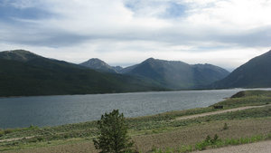
A beautiful vista of Twin Lakes on Independence Pass24 June, 2013 Monday – Denver to Independence Pass - Today I finished loading up my truck with last minute things such as ice chest, food, computer, etc. and headed out 470West and past the Hwy 285 exit to the Hwy 74 /Morrison exit and headed west. Morrison is a small town with the usual mix of restaurants and shops. If I had been heading to Red Rocks Amphitheatre I would have went North out of Morrison on Hwy 93 to the Red Rocks Park Road and took it to Trading Post Road and to the Northern upper parking lot which was more on a level with the Amphitheater.
http://www.redrocksonline.com/ Red Rocks amphitheater
As it was I continued on through Morrison and saw a sign for the Red Rocks Amphitheatre and so went to it to have a look at it from this side. It had a good size parking lot on the south side but involved a strenuous climb (for those not used to these altitudes) up some stairs to get to the theatre. I had already been to the amphitheater so felt no need to climb the stairs. I could have driven around the Amphitheatre using Trading
Post Road to the Upper Northern parking lot if I had wished.
Actually I am going to Steamboat Springs sometime next week and I may stop and take another look at the Amphitheatre then.
In any case after taking a few pictures and taking in the view a bit I headed back to Hwy 74 and went West towards Evergreen on a fairly scenic road.
When I arrived at Evergreen I slow rolled through it and had intended on stopping there to eat but as it was near noon the place was packed with tourist eating and shopping etc. and I didn’t see anywhere to park, so at the “Y” on the west side of town I went Southwest on Hwy 73 towards Conifer. At Conifer I got onto Hwy 285 heading southwest towards Fairplay.
Along the way to Fairplay I came across a road that was National Forest Access so I drove off onto it to see where it would take me. It went off into the forest and I came across several impressive beaver dams and ponds. So I stopped and looked at them a bit while snacking on some cheese and a pear.
After I got a good enough look I returned to the highway.
I climbed over the Kenosha Pass at 10,001 ft. and the Red Hill Pass at 9,993 ft. and arrived in Fairplay ready for a break and a bit of lunch. I wanted to get some gas but gas here was $3.99 a gallon so I only got about 10 gallons worth. There wasn’t anything to eat that was appealing so I continued down the road. Fairplay got its name because the miners who moved there from another mining camp did so because they felt they weren’t getting a fair deal from the previous camp….and now they are charging people $3.99 a gallon for gas ??!!
On the way south to Antero Jct. I passed several roads for access into the Pike National Forest and campgrounds off to the west. I also came by the West side of Antero Reservoir and if it was later in the day and the sun not so hot I could have went a bit East on Hwy 24 to camp there free.
But it was too early in the day for that and the sun too hot so I continued
on Southwest and over the Trout Creek Pass at 9,346 ft. and to the split a bit south of Buena Vista where I went North to Buena Vista on Hwy 24.
Buena Vista was a good size town with several restaurants and stores. I coasted through it and then turned around and came back again. In the middle of the town was a burger place called Old Fashioned Burgers and it may have been pretty good because it seemed to be the only place that was crowded. I didn’t see anywhere to sit although there may have been a small seating area inside.
I went to the supermarket nearby and got 4 pieces of baked chicken and some potato salad. They looked pretty good and I went to a picnic area I now found behind the hamburger place and ate a couple of pieces of the chicken and half the potato salad with some milk.
I considered renting a room in Buena Vista but there were some campgrounds I wanted to check out on Independence Pass, so after enjoying my meal and relaxing a bit I headed back North on Hwy 24.
When I got a

 National Forest access road
I took this Public Lands access off into the National Forest just to check it out.bit north of town I saw a sign saying “Railroad Bridge Campground” so I decided to check it out. The angle going in was too tight so I had to go down the road a bit to find a place turn around and came back. Once I got on the road I realized at once that this was another of those roads that once you get on it you are committed because there is nowhere to turn around. You just have to hope it doesn’t start heading up a mountain or something. I found out later this was CR 371.
The road was very narrow and I kept driving on and squeezed by another truck coming the other way fortunately at a location where there was a bit wider point for that purpose. After quite a while of uncertainty I came across some tents and campsites set up by people dispersed camping. I didn’t see anyone in the campsites so I kept going on. After a while longer I came to a place where there was a steep turnoff into a campground parking lot. There were a few people camped there and I asked a young couple setting up
a tent if they knew where the Railroad Bridge Campground was. They said they didn’t but if I continued on about another 5 miles south I would get back into Buena Vista.
That sounded good to me at this point as I was ready to get off this potholed and narrow road and back on pavement again. So I came back out of the parking lot and climbed up the incline to the road. It was pretty steep and my rear wheels slipped a bit , grabbed again and came up a bit then slipped again , then gripped again and my truck literally jumped up on to the road.
I continued on south again and came across a huge rock jutting up out of the ground and found some dispersed camping there as well. The rock was called “Elephant Rock”. The sun was still too hot to camp and I really wasn’t impressed with this campground.
So I continued on and the road stayed narrow and then went through a series of several tunnels. After a bit I came to a somewhat sterile campground all out in the open with no trees and this turned out
to be the “Railroad Bridge Campground”.
I had no desire to stay there now that I saw it wasn’t much more than a parking lot so I continued on south and finally came back into Buena Vista where I went north on Hwy 24 again.
I headed north and when I got to the junction with Hwy 82 (Independence Pass Road) I turned onto it and headed West. I came to a very nice, very picturesque lake with the mountains forming a beautiful vista behind it. This was the Twin lakes Reservoir. I checked out the first campground which was called “Dexter Campground” but it was a “parking lot” type campground with no water. So I passed on it and kept heading up Independence pass. I had talked to the guy who worked there and he told me that the “White Star” Campground further up the pass was a nice campground and it had water. So I continued my climb up the pass and when I came to the White Star Campground sign I turned off into it.
The campground had 3 loops but I chose the “Sage Loop” because it was closest to the lake. There
were “Reserved” signs on all the sites but I knew to check the dates on them and I found a nice one that the first reservation on it was over today and the second wasn’t for a couple of days yet. So I put my little tag on it and left a few things on the picnic table and then went up to confirm with the park host that there was no late reservation on that site. He said there wasn’t and so I put the envelope with the money in it in the tube for that and went back to my site for the night. After a bit the host came around and gave me a day use tag to hang on my mirror if I was staying a bit the next day and wanted to go down to the boat ramp area. I had found 2 or 3 other sites that had reservation signs on them but in fact were open for the night. I noticed the next morning they were still empty. The sites cost $18 but with my senior parks pass only cost me $9.00. So that was a good deal.
So I settled in
for the night and ate my other 2 pieces of chicken and the rest of my potato Salad. Then I put all the trash into a Wal-Mart bag and put it into the on-site bear proof dumpster.
It was nice and cool now and I enjoyed looking at the stars a bit. They were so much brighter up here.
After a bit I loaded everything back into my truck, let the seat back on the drivers side and dragged the big blanket I have behind the seat over me and got a good nights sleep.
It had been another good day : )
Advertisement
Tot: 0.517s; Tpl: 0.015s; cc: 14; qc: 80; dbt: 0.1846s; 1; m:domysql w:travelblog (10.17.0.13); sld: 1;
; mem: 1.3mb


D MJ Binkley
Dave and Merry Jo Binkley
Red Rocks
One of my dreams is to see a concert at Red Rocks. A couple of years ago when we were in Denver we climbed those stairs. What a work out! There were young kids running up and down the stairs for exercise. It was unbelievable. We would have used the upper parking lot if we'd known about it. The White Star campground looks like a great location.