Advertisement

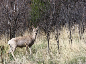
 Early Morning Sighting
Mule deer spotted on the road out of Sugarite SPWe had a great night in Sugarite St Pk. It was so quiet and dark. Nice change from the Wal-Mart parking lot. We took the scenic geological route to Capulin Volcano NP. The road went through good pasture land and climbed Johnson Mesa (about 8000 ft), which was very windy and cold. The temps there can go down to -30 degrees in the winter.
As we traveled toward the park it became obvious the entire region was a former volcano field. You could see cinder cones and vents all around (our travel book, of course, helped to point this out). We were close to CO and the state was visible from the top of the mesa. The road was 2-lane in good shape and had NO traffic.
We got to Capulin before lunch. It’s not their busy time of year. We saw 6 other people the entire time we were in the park. There was a mile hike around the rim of the volcano which gave a feel for the size of the cone. You could see miles and miles around -all those vacant plains!
We took the fast route back to Raton. This road was a main highway. We saw

 Johnson Mesa Methodist/Episcopal Church
Established in the late 1800's for the settlers of Johnson Mesasmall groups of antelope in the fields along the highway. When we got to Raton there was one more geological site to visit. We traveled up a gravel mountain road to find the “K-T” boundary. This boundary marks a major world-wide extinction in the fossil record, probably due to an asteroid or comet impact 65 million years ago. (WOW! Frank said he could see it).
We headed toward Taos about 1:30 pm, again on the scenic, geologically interesting route! We climbed toward the Sangre de Cristo Mountains, which are the southernmost part of the Rocky Mtns. The road zigzagged through the Cimarron River Canyon. This river is the most substantial we’ve seen in NM. The ride was very pretty - - ponderosa pines and a more of alpine scenery than desert. There were even patches of snow in the fields on the other side of the mountain.
We got to Taos around 5:00 pm and found a Wal-Mart by accident. Our journey today took us 184 miles.
Advertisement
Tot: 0.07s; Tpl: 0.012s; cc: 7; qc: 23; dbt: 0.051s; 1; m:domysql w:travelblog (10.17.0.13); sld: 1;
; mem: 1.3mb

 Early Morning Sighting
 Johnson Mesa Methodist/Episcopal Church


