Joshua Tree National Park


Advertisement
United States' flag
North America » United States » California » Twentynine Palms
September 18th 2017
Published: September 18th 2017
Edit Blog Post

the Park's locationthe Park's locationthe Park's location

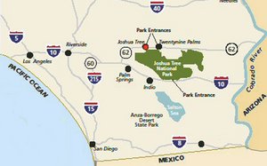
It’s in southern California, north of the Coachella Valley, at the juncture of the Mojave and Colorado deserts, starting roughly 140 miles east of Los Angeles. It has been a National Park since 1994.
The Joshua Tree National Park is a fascinating place to visit in southern California. It’s a huge territory containing over 1,200 sq. mi. (3,200 sq. km), roughly as large as the State of Rhode Island. About one-third of it is a designated wilderness area, accessible only by foot or on horseback, and what little rain it receives is unpredictable. A good paved road runs through the western part, and there are drivable unpaved roads, plus a number of hiking trails of varying lengths and degrees of difficulty. Mountains run along its southwestern edge, and there is a mile-high lookout point (Key View) that offers a breathtaking panorama of the Coachella Valley and the San Andreas Fault. It is the main destination for most casual visitors.

The Park overlaps two ecosystems, that of the higher elevation Mojave Desert and that of the lower Colorado Desert, each with its own characteristic vegetation. It is named for the “Joshua Tree”, a most unusual plant found almost exclusively in the Mojave Desert section. It can reach 40 feet (12+ m) in height, and lives hundreds of years. There are also five oases populated by fan palm trees and, surprisingly, large animal and bird populations.
western partwestern partwestern part

This is the higher level Mojave Desert portion. There is no public transportation to the Park, so you must approach it by car from Interstate 10 and California highway 22 from Palm Springs. There are three entrances … the west one is the one we took. There are also a north one a few miles farther to the east, and a south one, not shown on this sketch.


We were only able to visit the north-western portion of the Park this time, but we plan to see more of it on our next trip to California.


Additional photos below
Photos: 23, Displayed: 22


Advertisement

Joshua Tree NP signJoshua Tree NP sign
Joshua Tree NP sign

This is at the western Visitors Entrance, which we used, because we wanted to view the area with the most Joshua Trees.
first impressionfirst impression
first impression

When you drive in from the western entrance, at first all you see is desert with some shrubs, and mountains in the background. Slowly you come to appreciate the majestic solitude, though. That snow-capped one is Eureka Peak.
desert info boarddesert info board
desert info board

This board at a turnoff by the side of the highway reminds us that what may look like barren desolation really isn’t. The desert is a complex ecosystem, whose wildlife includes the coyote, roadrunner; bobcat, jackrabbit, golden eagle, rattlesnake, tarantula, over 200 species of birds, and various insects.
It's pretty barren at first.It's pretty barren at first.
It's pretty barren at first.

When you first enter the western part of the Park, you see mostly sagebrush with the occasional “Joshua Tree”. Apparently the eastern half (the Colorado Desert portion) has mostly creosote bushes, but before long the reason you came begins to appear …
Can't you just see ...Can't you just see ...
Can't you just see ...

… the Biblical figure Joshua holding up his arms to Heaven, imploring God for answers and directions? That’s what the first white men who saw this area (devout Mormons) thought … thus the name.
closeup of foliagecloseup of foliage
closeup of foliage

It’s not exactly a tree: it’s actually a giant member of the lily family,. It has a top-heavy branch system with leaves as much as a foot (30+ cm) long, and can live for hundreds of years. When there has been enough rain plus a cold snap in the winter, it may bear cream-coloured flowers and even fruit.
Hidden Valley & beyondHidden Valley & beyond
Hidden Valley & beyond

Here the paved road forks: to the left are various interesting parts of the overall Park, such as five desert palm oases, an abandoned dam and mine, a recently restored ranch, and access to the enormous eastern wilderness portion. To the right is the road to the Key View, the superb lookout above the Coachella Valley and the San Andreas Fault. Near the forks there are a campground, a small picnic-rest area, several piles of boulders, and some enormous rocks.
granite rockgranite rock
granite rock

This, and the photos that follow, show some of the unique enormous monoliths that occasionally appear in the middle of the flat desert. Geologists believe they were the result of lava forced up millions of years ago, cooled, and eroded over time.
pile of rocks ...pile of rocks ...
pile of rocks ...

… at the picnic and rest area
rest arearest area
rest area

It was well provided with toilets, garbage and recycling containers. Previous visitors obviously had been careful not to litter the area.
shaded picnic tables ..shaded picnic tables ..
shaded picnic tables ..

… complete with barbecue facilities and nice shade trees.
Key View plaqueKey View plaque
Key View plaque

Key View is a lookout located at an altitude of over 5,000 feet. It gives an good overall view of the Coachella Valley and the famous San Andreas Fault, the origin of many earthquakes, some of devastating destructiveness. It is shown by the red line across this plaque.
climbing to the top ...climbing to the top ...
climbing to the top ...

… of Key View. The parking lot is perhaps 200 feet (60 m) lower than the lookout, but there is a paved walkway.
Key View panoramaKey View panorama
Key View panorama

You can see the seemingly endless San Andreas Fault clearly. On a clear day you can see as far as the Mexican border. It's right some desolate country.
It's mighty windy at Key View !It's mighty windy at Key View !
It's mighty windy at Key View !

At one point we were almost blown over the protective railing, and we're not light!


19th September 2017
pile of boulders

Very interesting place. Great photos. Tell me, what did they mine in Hidden Valley?
20th September 2017

Thanks for the intro to another are I have not visited!

Tot: 0.257s; Tpl: 0.014s; cc: 22; qc: 108; dbt: 0.1163s; 1; m:domysql w:travelblog (10.17.0.13); sld: 1; ; mem: 1.2mb