Advertisement
Published: February 5th 2021

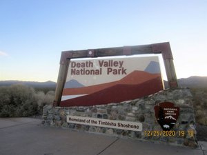
 Death Valley National Park
Hiked Corkscrew Peak, Ubehebe Crater, Kean Wonder Mine, and a little of Dante's View in the park.In late December, Anne and I traveled to southern California for a bit of hiking in Death Valley National Park and the Mojave National Preserve. On our last day there, we did one short hike in the Red Rock National Conservation area in Nevada near Las Vegas. This will be an abbreviated report just to keep it short and save a brief record for reference when we try to remember what we have done when.
On Thursday, Christmas Eve 2020, we flew into Las Vegas and drove to Beatty, NV for our motel. Due to the worsening pandemic in California, we were forced to cancel earlier reservations at Stovepipe Wells in Death Valley and stay at the Death Valley Motel in Beatty. We were there for three nights.
On Christmas day we tackled our most strenuous hike of the trip. An eight mile round trip climb up Corkscrew Peak in Death Valley NP. This was a hike with a 3,200 ft. elevation gain with most of that in the last mile and a half. This was one of the steepest trails we have done in a long time with an average grade of about 30

 Mojave National Preserve
Hiked Teutonia Peak and Barber Peak Loop trails in the preserve.percent on that last mile or so. The views all along the trail were impressive, and the 360 degree vista from the summit was spectacular. Almost worth all the energy it took to get there and back, which was about all the energy we had, since neither of us had much left when we finished. Oddly enough, three years ago on another Christmas trip to Death Valley, we decided not to attempt this hike because it sounded really strenuous. Three years later, three years older, and three years with more aches and pains, what possessed us to take on this challenge??? Guess we should be proud that the old hips and knees held up and we ‘bagged the peak’!!!
On Saturday the 26
th, we drove about an hour north in the park to the Ubehebe Craters near the Scotty’s Castle area. The main crater is about 400 feet deep and 2 miles around the rim with side trails to two or three smaller craters next to the main one. Elevation gain was a measly 500 feet, a piece of cake after Corkscrew the day before. After finishing the crater hike we drove back to the ruins of
an old gold mine called the Kean Wonder Mine. There we hiked about two more relatively flat miles to the springs that provided water for the mining operation.
On Sunday we drove from Beatty to Primm, NV, where we spent the night in a casino resort hotel, the closest lodging accommodation to Mojave National Preserve, our next hiking destination. We drove by way of a viewpoint in the national park called Dante’s View with the intent of hiking along a ridge line to a couple of high points a few miles from the viewpoint. Arriving there, the wind was blowing a gale with light snowflakes swirling around. The trial we intended to take was very narrow with a gravel surface, steep in places with sheer drop offs in places where a slip could have landed you in the valley 2000 feet below. We deemed discretion the better part of valor and just did a short hike down a wider trail for maybe a half mile or so before returning to the car and driving on to our “resort”.
We arrived at the Primm Valley Resort around 3:30 PM and pretty quickly decided that this
was not the place for us. The resort is a huge casino hotel that shares the complex with two other large casino hotels and an outlet shopping mall. The casino/hotel had one entrance in order to control access and screen for people that might be running a fever, a covid 19 precaution. After getting my temp taken, I had to walk through the gaming area to the hotel check in area where I determined that we could cancel the last two nights of our three night reservation with no penalty. Checked us in, then called a small mom & pop motel in Searchlight, NV, where the accommodations that were next nearest to the Mojave National Preserve were located. I was able to make reservations for a satisfactory room for the next two nights.
Spent that one night in the “resort,” then on Monday morning drove a little over an hour to the Teutonia Peak trailhead in the preserve. The hike to Teutonia Peak was about a 4 mile RT hike with a 750 foot elevation gain to the summit of a small mountain in the middle of a Joshua tree forest. There is also a side trail

 Corkscrew Peak trail
From along the trail with the valley in the distance.that leads to the remnants of an abandoned silver mine and adds about a mile or so to the total length of the hike. Unfortunately the Joshua tree forest has been decimated by one of the many California wildfires that occurred during August of 2020. Teutonia peak is located on the edge of Cima Dome which, at 1,500 feet tall and covering seventy square miles, is the most symmetrical dome of its type in the United States. Consequently this wildfire was named the “Dome Fire”. There are still lots of Joshua trees in the area that were not burned ,but the fire torched some 40,000 acres and destroyed thousands of Joshua trees. We could smell the lingering odor of burnt landscape some four months after the fire had been extinguished. Nevertheless, the hike was a good one even with a temp that was just above freezing when we started around 9:00 AM and a steady 20 mph wind that gusted to 40 or 50 mph at times. It had snowed the night before so the desert covered in a light blanket of white was a uniquely beautiful sight when we started out. As the day wore on, the sun pretty

 Corkscrew Peak trail
From along the trail. Our car is down there somewhere.quickly evaporated the snow revealing the charred remnants of the desert cacti, grasses, and blackened trunks of the Joshua trees.
After our hike to Teutonia peak, we drove to the visitor center area in Kelso, CA, in the middle of the preserve where we ate lunch in the car. We then drove to the Kelso Dune Field area where we hiked a short mile or so to near the foot of the first dunes. The hike to and over the dunes is probably the most popular in the preserve but, having hiked in sand dunes before at White Sands and Great Sand Dunes NPs, we did not feel the need to hike these along with lots of other folks.
After our visit to the dunes, we drove to Searchlight, NV, where we checked into the El Rey motel, one of two small, very (emphasis on very) basic, motels in the area. Searchlight was an extra half hour from the Mojave Preserve than it had been from Primm but we didn’t have to put up with all the resort complications. It is the home of former senator Harry Reid who says the town got its

 Corkscrew Peak trail
This shows the last part of the trail. That's the peak at the top, about one mile away and 2,000 feet higher.name from a gold prospector who said it would take a searchlight to find gold ore there. The El Rey motel is the namesake of a famous 1940’s and 50’s hotel/casino that also housed a bordello. No bordello at the El Rey Motel these day however, but a pretty decent small motel with pretty much all you need for a comfortable nights rest.
Once settled in at the El Rey we were able to get back on the internet where we found an e-mail from our neighbor, Joan, telling us one of our cats was ill and to please call. Anne spoke to Joan and, to make a sad story short, ended up having to authorize euthanasia for poor Gracie, the most uniquely loving cat Anne has ever had. Gracie tolerated me but was devoted to Anne. Needless to say the rest of the trip was not a happy time.
On Tuesday we drove back to the preserve and the Hole in the Wall area. The area is named after the holes that appear in the sides of the surrounding hills & buttes. A few million years ago, the eruptions of a nearby volcano

 Corkscrew Peak trail
From along the trail, an interesting formation on the right with the valley on the left in the distance.covered the area with a mixture of lava, gas and ash. As the ash cooled and the gas began to dissipate, the gas bubbles within the cooling lava expanded forming large holes. This was an hour and a half drive that included a 16 mile section of very rough dirt and gravel road. The hikes there were the Barber Peak Loop Trail and Rings Loop Trail. Barber Peak Trail encircles Barber Peak, a massive mound of rock with dramatic cliffs and intriguing rock formations that change at every angle. However, the trail itself is a relatively boring trudge through the desert prairie that is shared with lots of cows. Though we only saw two cows, we saw evidence of lots and lots more all along the way. The Rings Loop trail connects with the Barber Peak loop and includes a section in a slot canyon where sturdy metal rings have been secured into the canyon rock to provide assistance climbing up or down some very steep pour-offs in the canyon. We managed a short section of this trail just to get the experience of climbing over the rings. All in all, we hiked a total of around 8 miles on

 Corkscrew Peak
Lunch at the top.these trails with an overall elevation gain of 600 or so feet. Finished our hikes around 3:00 PM and drove back to the El Rey.
Wednesday we checked out of the El Rey and drove to the Red Rock National Conservation area near Las Vegas. We had made a required reservation for 10:00 AM to drive the one way 13 mile Scenic Drive through a portion of the park. We wanted a place to do a short stretch your legs hike on our last day of the trip, and this looked like a good choice. Lots of trailheads were located along this road and we chose one that hiked to a picnic area with some interestingpetroglyphs at the end. Ended up hiking about 5 miles through some interesting terrain before getting back in the car and driving to our hotel in Las Vegas for out last night of the trip.
The flight home left a little after 7:00 AM Thursday morning and connections through Atlanta were on time so we make it home on schedule around 6:30 Thursday evening.
Advertisement
Tot: 0.189s; Tpl: 0.016s; cc: 10; qc: 46; dbt: 0.1268s; 1; m:domysql w:travelblog (10.17.0.13); sld: 1;
; mem: 1.2mb


