Advertisement
Published: December 6th 2012

 Doubtful Canyon
You will need a spirit of adventure and stout 4 wheel drive vehicle to visit Doubtful Canyon. From the corner of 3rd St and Indian Springs in San Simon (it is at the east end of town north of the freeway ramp and railroad tracks) go east about 6 miles. At the junction turn northwest and follow that road for about 5 miles. You will cross a gas line easement after 3.7 miles.DOUBTFUL CANYON
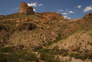
Coronado found his way through this canyon on his quest through Arizona in search of the Seven Lost Cities of Gold. It later became the trade route between Mexico City and Santa Fe. The San Antonio and San Diego mail route passed through here, and so did the Butterfield Trail. It was the route for all commerce coming into or going out of Arizona either to or from the east. It was not the easiest route, but it had a reliable water source. Water was absolutely crucial to travel. During the Cochise War, which began in February of 1861, safe travel through the canyon became a doubtful proposition. Mail riders were paid handsomely for carrying mail between Mesilla and Tucson, but few of them survived the trip. It might be that the term Doubtful Canyon originated with those mail riders. The Giddings brothers, George and John, took up operation of the mail line between San Antonio and San Diego after the Butterfield failed. On April 23, 1861 a provision wagon failed to arrive as expected in San Simon from the station near Stein’s Peak. On April 27 a stagecoach carrying John Giddings himself also disappeared in that area. When a couple of badly bruised company mules made it back to the station 25 men were hired to go have a look. Giddings badly mutilated remains were buried where his body was found. The location of that gravesite is well known. After the Army pulled out in 1862 Apaches all over the territory jumped into the fray, settlers along Sonoita Creek and around Tubac had to abandon their crops and farms and were driven to the safer confines of Tucson. A couple of them, Wadsworth and Ake, decided to take what they could salvage from their precarious lives and make for Texas. They organized a wagon train and several other families joined them. The group was strong enough to have survived an attack by Cochise in Doubtful Canyon, but came very near complete annihilation at the hands of Mangas Coloradas in Cooke’s Canyon two days later. There are many sites in the southwest where conflict with Apaches took place, but few of those sites met with either such lopsided success for them, or such grim results for their adversaries. The photo shows what must have been one their favored ambush locations. It would have been the site of unimaginable pain and horror to all who were caught here.
Advertisement
Tot: 0.247s; Tpl: 0.009s; cc: 10; qc: 49; dbt: 0.1077s; 1; m:domysql w:travelblog (10.17.0.13); sld: 1;
; mem: 1.2mb

 Doubtful Canyon