Advertisement
Published: October 4th 2017

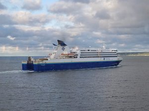
 An example of the ferry we took
This is like the ferry we took from Newfoundland to Sydney, Cape Breton. This one was leaving the harbor on its way to Newfoundland as we were driving a loop road around the northeast coastline of Cape Breton.I'm posting from Halifax after spending a couple of days here. Tomorrow we head to Yarmouth, on the southwest end of the Nova Scotia peninsula, where we will board a ferry to cross back over to the US at Portland, Maine.
We drove directly from Sydney in Cape Breton to Halifax, about a 4 hour drive. Most of the drive was through the heart of Nova Scotia, which is mostly thick trees and rocky fields, like much of the interior areas of Atlantic Canada. There were some prettier areas as we got along the coast and caught views of the Atlantic Ocean along the eastern coastline.
Halifax is a pretty interesting city. Actually, half of the urban area is Halifax (the south side of Halifax Harbor) while the other half is Dartmouth (the north side of the harbor). There are a couple of bridges that cross over the harbor, otherwise it ends up being a loooong drive around. We stayed in Halifax proper. We spent our first day in Halifax checking out a couple of antique stores and a fairly nice hobby shop that was located right downtown. Boy howdy, we think parking is bad in Portland! Try finding

 The Sydney Harbor
This is a view of the Sydney Harbor that feeds into the Port of Sydney. This view is from the coastline that runs along the eastern shore of the harbor.a parking place in downtown Halifax, especially when 3 cruise ships are in town and about half the streets in the downtown core are under construction.
We drove by the VIA Rail station and found a train waiting there to head back to Quebec. Right across the tracks from the station is the cruise ship wharf. We saw one of the largest cruise ships I've ever seen docked there. After wandering around downtown, we headed out of town and drove down to the most photographed area in Nova Scotia, Peggy's Cove. It was a beautiful area, a quaint picturesque stereotypical fishing village ruined only by the 8 tour buses and approximately 500 tourists walking around the small village. Looked like ants on a spilled ice cream cone.
Today we just kind of knocked around, ran some errands, saw a movie, had lunch at a neighborhood pizza parlor that just happened to be located right next door to a craft brewery. And, wouldn't you know, they let us take our food over to the brewery to eat so we could have something good to drink. I tried something new that apparently is unique to Atlantic Canada and is especially
well know in Halifax. It's called a Donair, and is shaved beef in a gyro roll with vegies and some type of spiced yogurt sauce. Actually pretty good, although messy as hell.
Tomorrow we'll head up along the western coast of Nova Scotia which runs along the Bay of Fundy on our way to Yarmouth. Then on Friday we're scheduled to take the ferry across to Portland, Maine. So by end of day Friday we'll be back in the old USA again. I'll update again when we get to Bangor, our first overnight stay in Maine.
Advertisement
Tot: 0.091s; Tpl: 0.014s; cc: 10; qc: 55; dbt: 0.0472s; 1; m:domysql w:travelblog (10.17.0.13); sld: 1;
; mem: 1.1mb

 An example of the ferry we took
 The Sydney Harbor
