Advertisement
Published: December 6th 2014

 Tablelands
A table indeed!Barely outside Corner Brook, we stopped to look at a rock formation called the Man in the Mountain. Seeing that face in the rock took strong imagination. Oddly, there is a much more discernible face in much the same place, but it is uncelebrated.
We took the Transcanada to Deer Lake, which is named for the caribou, as there are no deer in Newfoundland and Labrador. There, a specialist guide, Paul, joined us for our time in Gros Morne Park. We took the smaller “
Viking Trail” northwest to Bonne Bay, an extensive bay that dominates the geography south of the Park.
We entered
Gros Morne Park. Driving north, we were first introduced to the
Long Range Mountains, which stretch most of the length of the island; they are part of the
Appalachian Range. Even though ancient and worn down, they still have the look of mountains, not hills. To the west rose the
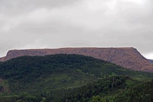
Tableland Mountains. As suggested by their name, they are remarkably flat on top. Almost nothing grows there - visible from the highway at least. The rock is red, with lots of loose boulders strewn everywhere.
At last, to the east in the distance, Gros Morne itself came into view, almost like a

 Gros Morne
The focus of my vision for this trip!gigantic boulder on the landscape. The tree-line was about 30%!u(MISSING)p the steep slope. With relief I came to terms with my decision to give up on the walking tour of Gros Morne Park – both the Tablelands and Gros Morne are well beyond my hiking capability and scrambling over rocks is not my idea of fun. (Waiting in the airport ten days later, I overheard a relatively young, burly man describing the ascent of Gros Morne, which he found tough and cold – more confirmation for my decision.) Comfortable on a high deck, we took photos from the interpretation centre.
We moved on to
Trout River, a traditional fishing village still. They have a boardwalk on the sea front, where we met a fisherman who showed us his “room”. This is the name for the building where all the equipment and catch are stored and processed. He pointed out the
salted cod in all its stages: soaking in rectangular plastic tubs of strong brine, laid out to dry on lobster pots (flies, of course), and finally fully salted and dried. In his freezer was a large halibut (almost the length of the freezer) in the process of being frozen just

 Trout River
Fishing the Gulf St Lawrence still provides a livelihood. enough to cut easily. Like all traditional fishing families here, he is self-sufficient, with calves, ducks and chickens in a shed near his “room”.
Now we drove to
Woody Point for lunch and the opportunity to take a water-taxi, like the locals. I couldn’t face a 45-minute ride when the bus was driving peacefully around an arm of
Bonne Bay. As quickly as possible, I bought an egg-salad sandwich and a tea-bun liberally doused with partridgeberry jam, and climbed into the front seat of the bus. Driver Barry was friendly, answering all my questions as I thought of them. None of the tour members ever noticed my absence, or at least never commented on it. As we reached
Norris Point, the water taxi docked, perfect timing.
The road followed the valley along the Long Range Mountains, occasionally giving us more glimpses of Bonne Bay with its fjord-like arms. Then we were driving along the sea coast, flat green land to the west of the mountains. We said goodbye to guide Paul at the almost barren
Sally’s Cove, and refreshed ourselves with coffee and partridgeberry pie. It seems that even while enjoying the strange scenery, the underlying monotony of highway travel invites the

 Salt cod
This is what I eat at home, bought in pristine plastic packages.eating of desserts. Two more hours of sea and mountain views brought us to the flat land along coast and to the
Plum Point Motel.
By now I was in desperate need of a long walk, unavailable in Plum Point. So I made do with multiple brisk rounds on the nearby boardwalk. Refreshed at last, I came across fellow tour member, Don. He was drawing an unknown flower into his sketchbook. When I showed some interest, he gave me a truly enlightening view of nature from his artist’s eye. He drew my attention to the veins of the plants and showed that a curved line always meets a straight line or an opposite type of curve (sharp curve or smooth curve), called rule of opposites. He showed that both the shades and textures of top and bottom of leaves are different and that the colours are either harmonious or complementary, often red and green. Fruits ripen in the same order of colours in the rainbow, that is, green-yellow-orange-red or green-blue-indigo-violet. I will always see plants with a new eye!
Buffet dinner: tomato juice, vegetable beef soup, salmon fillet, soggy peas and carrots, bread and butter, lemon pie, Iceberg beer from

 Driving to Norris Point
My own special view from the front seat of the busQuidi Vidi
Route to Plum Point
Advertisement
Tot: 0.091s; Tpl: 0.013s; cc: 8; qc: 24; dbt: 0.0425s; 1; m:domysql w:travelblog (10.17.0.13); sld: 1;
; mem: 1.1mb


