Advertisement
Published: October 13th 2012

 On top of the world
High above Emerald Lake on the Wapta Highline trailAfter a quick overnight pit-stop in Lake Louise I was all set to spend the next few days hiking in Yoho National Park (Yoho being the native Cree word for 'awe'😉 on the other side of the Great Divide in British Columbia. My initial intention had been to cycle the 30kms from Lake Louise to Field (in the centre of Yoho NP), first climbing over Kicking Horse Pass and then turning off onto the Yoho Valley Road to tackle the steep climb up to the HI wilderness hostel opposite Takakkaw Falls, where I had booked a dorm bed for two nights.
This idea I had chosen to abandon when I saw the amount of construction being done along the Trans Canada Highway between Field and Lake Louise when I passed by on the Greyhound bus on my way up into the Rockies. My second choice had been to leave my bicycle in Lake Louise and take the Greyhound bus to Field, before hiking the 20kms past Emerald Lake and over Yoho Pass to the hostel; but this I was hesitant to do due to the extortionate cost ($20 each way) of taking what would be no more than a thirty-minute

 Meeting of the Waters
Confluence of the Kicking Horse and Emerald Riversbus ride.
So when the receptionist at the hostel in Lake Louise suggested that it would be just as easy (and much cheaper) to hitch a ride along the highway, I figured I had hit upon the perfect solution. Of course, never having had to hitch a ride anywhere before, I really had no way of knowing what the likeliness would be that someone would actually be prepared to stop and offer a ride to some guy with a backpack on the side of the road... but hey, what did I have to lose?!?
So having left Lake Louise on the friday morning (20th July), I set off westward alongside the Trans Canada Highway holding a makeshift 'Field' sign that I had fashioned from a box of rice krispies. On and on I walked, with the hot sun beating down on me and my mood slowly but surely dropping in inverse proportion to the rising temperature. And when finally, forty-five minutes and about four kilometres after I had left Lake Louise, a local guy took pity on me and pulled over to the side of the road to offer me a ride, the sense of relief was almost
overwhelming!
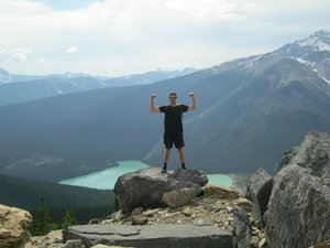
Not far outside of Field is the Natural Bridge, where the fantastically-named Kicking Horse River has carved a hole through the rock. From there I followed an old fire road to the Kicking Horse River's confluence with the Emerald River, before turning and following the Emerald River upstream for a further eight kilometres all the way to the perfectly-named Emerald Lake, which despite the overcast weather seemed to glow a brilliant turquoise colour.
After following the western shore of Emerald Lake for a few kilometres - with the imposing profile of Mount Burgess rearing up behind the lake - the trail crossed some alluvial flats before beginning the steep, switchbacking climb up to Yoho Pass - which despite gaining only about 400 metres in elevation had me suffering and cursing more than any of the previous climbs (many of which had been longer, steeper and gained a lot more elevation) that I had done in the Rockies.
Eventually though I reached the forested crest of Yoho Pass and took a rest break beside the picturesque Yoho Lake, before tackling the even steeper descent down into Yoho Valley, where the sound of the 375-metre-high Takakkaw Falls plunging
from the cliffs on the opposite side of the valley could be heard long before I got my first sight of the awesome natural spectacle; at which point I had to agree with the native people who had long ago bestowed the waterfall with it's name, which means 'it is magnificent'.
Unfortunately the weather on saturday was awful, with rain falling constantly until around two in the afternoon, at which point I finally donned my wet-weather gear and headed over for a close-up view of Takakkaw Falls, before setting off up the Yoho Valley to check out some of the other nearby waterfalls. A distant view of Angel's Staircase Falls, a close-up view of Point Lace Falls and then a quick stop at Duchesnay Lake were mere samples of what was to come; before the roaring thunder of the strangely-named Laughing Falls raised the stakes significantly, only to be outdone by the spectacular sight of Twin Falls leaping off the cliffs at the far end of the valley - at which point I couldn't tell what was cloud, what was rain and what was spray from the waterfall... all I knew for sure was that I was getting wet!
Having set myself the ambitious task of hiking around twenty kilometres - up and over Yoho Pass, then even higher along the side of Wapta Mountain to Burgess Pass at an elevation of over 2200 metres, and finally the thousand-metre-plus descent on the other side - to get back to Field on sunday, I woke that morning to be greeted by a most unexpected sight... a clear blue sky! The irony of the fact that this was exactly the sort of weather I had been hoping for the previous day when I had wanted to hike the Iceline trail (which also reaches an elevation of over 2200 metres - high above the treeline - and therefore offers panoramic views of the entire valley) but which I would not have time to tackle on sunday, was certainly not lost on me.
So the best I could do was to console myself with the short trek back over to the base of Takakkaw Falls, where I was at least able to get some nice pictures of the highest waterfall in British Columbia (and fourth-highest in the whole of Canada) and absorb as much as possible of the power and beauty

 Alpine grandeur
Glacier and lake beside the Iceline trailof this natural attraction; all the while rueing the weather for having so cruelly curtailed my plans the previous day, and wishing that I could somehow make up for it by adding the Iceline hike onto the already long day of hiking that I had planned - only to then remind myself that to do so would be to add another twelve kilometres or more (and another arduous climb of around six hundred metres) to what was already going to be a challenging day.
But once that seed had been planted in my mind, there was never going to be any getting rid of it; so after soaking up the atmosphere (and spray) of Takakkaw Falls for half-an-hour or so - and against my better judgment - I found myself heading back up the Yoho Valley along the same trail that I had followed the day before, despite the fact that my ultimate destination for the day (Field) lay in exactly the opposite direction!
It was only after once again stopping off to see Angel's Staircase Falls, Point Lace Falls and Laughing Falls, that I was finally able to branch off onto a different trail that led me
across the valley floor (past the beautiful Celeste Lake) and up the lower slopes of the President range to where I was finally able to intersect with the Iceline trail - at which point I knew immediately that I had made the right choice and that the extra effort involved in getting there had been worth it, for the view of the upper stretches of the Yoho Valley spread out before me was nothing short of breathtaking!
With a glacier rising immediately above me to the west, and the whole of the Yoho Valley slowly being unfurled below me to the east, I followed the Iceline trail on it's undulating path through loose rocks and lingering snowfields, past small alpine lakes and across bubbling streams created by fresh, cold glacial meltwater; all the while mesmerized by the breadth, clarity and beauty of the panorama laid out before me, with the unmistakeable form of Takakkaw Falls now lying hundreds of metres below me on the opposite of the valley.
Finally, sometime around mid-afternoon, I passed what would have been the start of my hike - if not for my impromptu detour - and started my descent towards Yoho Lake

 Rugged peaks
Wapta Mountain, with the President range in the backgroundand Yoho Pass (the same pass that I had slaved away trying to get up to only two days earlier), before immediately starting to climb once again along the flanks of Wapta Mountain. Thankfully though this climb was much more gradual, and with an entirely different, though equally spectacular, panorama (this time taking in Mount Burgess, Emerald Lake and the gnarled, imposing facade of the President and Vice President) opening up before me the further I went - and with regular photo stops providing frequent rest breaks - I was able to make good progress as I slowly but surely ventured ever higher up the slopes of the ridge.
Eventually I arrived at Burgess Pass, where I was not only able to take one last look back at Wapta Mountain and the entire Emerald Lake basin; but also able to take in the view of the previously-obscured Kicking Horse River valley, with the small town of Field a full vertical kilometre below, backed by the towering walls of Mount Stephen and Cathedral Mountain directly opposite me. And from there I had just one last obstacle to overcome - the potentially knee-wrecking (if not quite soul-destroying) descent of the southern

 Lofty views
View of Field and Mount Stephen from Burgess Passslopes of Mount Burgess, featuring over fifty switchbacks in the space of six kilometres, with an elevation loss of over a thousand metres... and all of this after I had already hiked at least 25kms for the day, climbing well over a thousand metres along the way! Oh, and then there was the small matter of having to get back to Lake Louise - which, if my debut hitchhiking experience only two days earlier was any sort of guide, could mean having to walk alongside the Trans Canada Highway for another five kilometres or more!
Thankfully though the descent from Burgess Pass to the outskirts of Field was not too arduous, and within twenty minutes of reaching the highway I had managed to score a ride from a passing motorist to the junction of the Trans Canada Highway and Icefields Parkway (which I would be cycling along the following day) just outside of Lake Louise, leaving me with just a short walk back to my 'home base' in the Rockies - which I polished off with a smile on my face and a whole day's worth of incredible memories etched into my mind.
Advertisement
Tot: 0.087s; Tpl: 0.014s; cc: 12; qc: 28; dbt: 0.0567s; 1; m:domysql w:travelblog (10.17.0.13); sld: 1;
; mem: 1.1mb


