Advertisement
Published: August 1st 2016

 E93I4553s
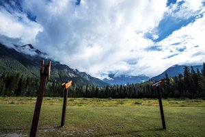
Base of Mount Robson at Jasper National ParkITINERARY Day 3
The group travelled from Valemount to Lake Louise covering about 350 km.
There were seven stops.
1) Base of Mount Robson at Jasper National Park
2) Moose Lake
3) Athabasca Falls
4) Columbia Icefield
5) Glacier Skywalk
6) Bow Lake
7) Lake Louise at Banff National Park
REFLECTIONS
Driving on an easterly direction, the route from Valemount to Columbia Icefield is one of the most scenic drive. The highway runs along the valley through the Rockies with a river on its side, sometimes on the left and other times on the right. Pine forest lined both sides and conical tips of mountains can be seen puncturing the low clouds. Some peaks were snow-capped and glaciers like cream drippings down the slopes.
1) Base of Mount Robson at Jasper National Park
Mount Robson was the highest peak in British Columbia. However, she was too shy to reveal her

 E93I4562s
The surrounding mountain peaks around Mount Robson were not so shy and I managed to capture a few photographs.
.
peaks due to the heavy clouds in the morning. The surrounding mountain peaks were not so shy and I managed to capture a few photographs
.
2) Moose Lake
The green river (probably from algae that thrived on summer) on the right of the highway gradually broadened into a lake. We stopped to capture some of the scenic moments. It was rumoured that the name (translated from the French:
Lac d'Orignal) was given because of the large moose population of the area. It was a pleasant surprise when we saw a moose feeding on the side of the highway as we move away from Moose Lake.
3) Athabasca Falls
Our tour guide suggested a visit to Athabasca Falls because the heavy downpour at the mountains he day before would provide torrential running water down the Athabasca River. We were not disappointed and marvelled at the milky white rushing water, foam and mist generated at the waterfall. In summer, swollen by water from melting glaciers and rain, the river runs milky white due to the ‘rock flour,’ fine silt from the product

 E93I4563
The surrounding mountain peaks around Mount Robson were not so shy and I managed to capture a few photographs.of grinding down mountains for thousands of years.
4) Columbia Icefield
This is the largest icefield in the Rocky Mountains of North America. Located in the Canadian Rockies astride the Continental Divide along the border of British Columbia and Alberta, Canada, the ice field lies partly in the northwestern tip of Banff National Park and partly in the southern end of Jasper National Park. Water from the melting glaciers of the Columbia Icefield fed rivers that flowed into the Artic, Atlantic and Pacific Ocean.
Out tour bus dropped us at the Columbia Icefield Information Centre where another bus brought us to ride onto the surface of the Athabasca Glacier in the all-terrain Ice Explorer – a massive vehicle specially designed for glacier travel. The Ice-Explorer had six large wheels that can negotiate the slippery ice and water on top of the glacier safely, even at slopes of about 45 degrees. We alighted at the middle of the Athabasca Glacier and took photographs for about 20 minutes before hurrying back to the Ice-Explorer because of the sub-zero temperature on the glacier aggravated by chilling

 E93I4576s
The green river (probably from algae that thrived on summer) on the right of the highway gradually broadened into a lake, Moose Lake. winds.
5) Glacier Skywalk
The beginning of the walk on the edge of the cliff was about 8 minutes bus ride from the Columbia Icefield Information Centre. After walking for around 250 meters, we reached a glass-floored observation platform 918 feet (280 metres) over spectacular glacier-formed valleys and rushing waterfalls.
6) Bow Lake
Bow Lake is located on Bow River of the Canadian Rockies at an altitude of about 1900m can be reached from a side road off Alberta Highway 93. It is a small glacier lake in western Alberta, Canada.
7) Lake Louise
Tom Wilson called this Emerald Lake in 1882. In 1884, it was renamed Lake Louise in honour of Princess Louise Caroline Alberta, Duchess of Argyll.
Advertisement
Tot: 0.073s; Tpl: 0.01s; cc: 9; qc: 46; dbt: 0.0419s; 1; m:domysql w:travelblog (10.17.0.13); sld: 1;
; mem: 1.1mb

 E93I4553s
 E93I4562s
 E93I4563
 E93I4576s


