Advertisement
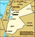
Jordan: a quick flit
Jordan! Is it possible to offer a caption that describes the nation? No. The experiences we've encountered are just too diverse.
We were short of time when considering our travel options and decided to join a Peregrine organised tour. In many respects, we're glad we did.
As always, if you want to see the picture in a larger size, just click on it. Day 1 - May 5: arrival
We arrived late in the day to be confronted with a queue awaiting Visa payment (
A$80 per person!! - then again, that was better than the A$176 pp in Oman), and so didn't depart the airport as quickly as we'd hoped. The driver (prearranged to get us to our hotel) indicated it was a 40 minute trip - it took a little over 2 hours. Apparently, everyone needed to be on the road to get last minute shopping for Ramadan beginning the next day!
After checking in and finding a beer (we were parched!!), we sought dinner. Sadly the hotel options were undesirable so asked if there were
any restaurants nearby. "
Yes, Sir, left outside the door and walk 10 minutes along this road." Half an hour later, after negotiating maddening traffic and almost non-existent footpaths, we came across a few Filafel joints! The Jordanian Filafel is markedly different to the Aussie product. Merely slices of BBQ'd meat (same) in a flat bread wrap. A few pieces of tomato and pickled gherkin, and that was it! Welcome to Jordan!
Day 2 - Wadi Rum
After what appeared as a very short sleep, breakfast and checkout, we joined 8 others as part of a group to 'do' Jordan. Our destination on day one was
Wadi Rum. After a 4 hour bus ride, we stopped at the 'store' at Wadi Rum village for lunch provisions. Flat bread, a few tired banana's, plenty of sugary &/or salty snacks, some dips (like hommus) and a range of sugary soft drinks appeared the only options - unless we wanted tinned food. Once loaded up, we transferred to the backs of Ute's to be driven to our 'rest area'. The 'rest area' was a tented arrangement with locals offering artefacts for sale! With a few camels outside for those
 Wadi Rum landscape
This is the same place where a photo of Lawrence (of Arabia) was 'snapped'.willing to be taken for a ride, fortunately, flies were scarce. We'd picked up a bottle of Lemon and Mint drink, and with the flat bread, tomato and hommus we’d picked up at the ‘shop’, we managed to revive ourselves.
Back in the tray of the ute, we were taken to various ‘sights’ before being delivered to our tented ‘accommodation’. The ‘office’ tent had aircon and the group had no problem squeezing in. We were given our ‘tent’ key and we headed along the path to a large tent with a big sliding glass door. Inside there was an aircon, but it was struggling with felt like a 45 degree temperature. We deposited our bags, left the door wide open and headed back to the ‘office’ tent for a beer. The only beer available was a non-alcoholic product. It whet the whistle, but little else. Returning for a shower, we eventually made our way to the dining tent. The food was traditional, but sadly, well overcooked. The Creme Caramel and bread + butter pud resolved any tension. After dinner we headed over to a seated area around a log fire for ‘traditional’ tea; a sweet spiced tea that was
surprisingly enjoyable.
On reflection, the scenery was astounding. We’d left a reasonably green landscape in/around Amman and as we headed south, there was a marked change of landscape to desert. We understand that the geology changed from a basic limestone (green) to sandstone (dry). About 200km into the journey, the bus descended down a steep escarpment onto a plain with seriously scenic rocky outcrops. These rocky outcrops often revealed sheer sides that exposed differing rock structure revealing that some time in the past there had been massive geological uplifts. Perhaps the only ‘downer’ was that unless we were close to a rocky outcrop, the dust laden air prevented good ‘grand view’ photography.
Day 2 - Camels & Petra
After a good sleep and a reasonable breakfast, we mounted into the ute trays and headed back the way we came. When nearing the village of Wadi Rum, the utes stopped beside a mob of Camels (is that the right word?), where we dismounted and sheepishly awaited help to mount these ungainly looking animals. Judy attempted the task first, but the camel decided to arise while she was only partly in the saddle. With much supportive pushing and
heaving, she eventually (re)gained her composure.
Off we went, the animals roped in single file and led by a local. We now know why they are called ‘ships of the desert’! Our ride was akin to the heaving of a ship as it encounters waves. Fortunately, nothing outrageous eventuated and after some time we dismounted to make our way to the awaiting bus.
A 2 hour bus ride took us to the town of Petra (and our hotel). After dropping our bags into the hotel ‘safe room’ (11am was too early to check in), the bus took us to the official Petra entrance.
Petra is the religious site of the
Nabataean peoples. The sprawling site was both a religious prayer area and mausoleum. Construction began sometime in the 1st Century BC and continued until a large earthquake in 363AD destroyed much of the site. The site was apparently abandoned not long after.
After the formalities of entering the ‘site’, our group and guide headed down the slope into a canyon of ever increasing height and progressively narrowing walls. Along the way, our guide pointed out carved religious icons, and other engineered works. We turned a bend and
through the tall narrow canyon walls we could see ‘daylight’ (ie. an enlarged open area) and the facade of the Treasury. The Treasury is so well known we didn’t have to be instructed as to what it was. That said, the Treasury is a huge edifice carved into a sheer wall of sandstone rock. We learned that unlike similar edifices we were soon to see, this one had a special feature: to minimise rainwater damage, the edifice is recessed well into the rock. The large open forecourt was filled with gaudy shops, many camels, horses and donkeys (with owners touting for business) and innumerable tourists. For us, the bedlam diminished the beauty of the artefact. Our guide instructed that it was the edifice of a royal tomb, and was merely a large chamber inside. At the top of the edifice was carved a large ball. At some earlier time, locals had taken potshots at it on the belief it was filled with gold (hence the name Treasury).
We headed further into the site and as we did the canyon walls receded to a much more open area. This began what we coined ‘the vista’; edifices of various shapes and
sizes as far as the eye could see. We progressed to an amphitheatre (much like a Roman version) carved out of the hillside. Unlike Roman amphitheatres where the seats were constructed from flat ground, the Nabataeans had carved every level out of the rock. Even the rooms servicing the amphitheatre were carved into the hillside. We were told there was a sacrificial alter higher above with a drain that entered into the centre of the amphitheatre. And, at least once a year, a major sacrifice was undertaken and the blood drained into the theatre basin!
A short distance away was a store run by a New Zealand woman and her son. She had visited Petra and became bewitched by a (Petra) Bedouin man. The result was a life in a cave and two children. Since the World Heritage listing, all tribes people have been removed and she has a house in Petra town. We met her son who speaks with a broad Kiwi accent. That was as far as we travelled today, tomorrow we will return.
Day 3 - A full day at Petra.
After a sumptuous feast and a good night’s sleep we returned
to the Petra (archaeological) site. With only 2 others, we smartly made our way to the Amphitheatre where we took stairs up the very steep hillside to the Sacrificial Alter site. Arduous as the climb was, the view and history was worthwhile. We were told by a resident guide that sacrificial offerings occurred year round, but there was an annual offering of ‘biblical’ proportions. On one day of a year, all the (status?) families came to the Amphitheatre with one, but generally more, goat to be sacrificed. There were some 3000 families, so the slaughter was huge in scale. The males of each family would climb to the Alter with their goats. A priest would slaughter them and the blood drained into the small cavity in the rock. The family members would place their hands in the blood and then proceed to a statue (god?) and wipe their hands on the statue for blessing. Then, they would wash their hands and return to the Amphitheatre.
We proceeded along the track - our guide had yesterday advised it was a pleasant shortcut the the ‘Basin’ (a major archaeological site) and was largely devoid of tourists. Though more strenuous due to
heaps of stairs up and down the hillside, we got to see some amazing tomb sites. One in particular was quite ornate inside.
After a stop for lunch we progressed to the Basin and head up up the other hillside (via some 750 stairs) to the Monastery - so named because Nabataean elders held meetings of religion inside. The facade was even larger than the Treasury. We then retreated our steps to the Basin and headed back by the ‘main’ track.
Overall, we calculated we each walked about 15 kilometres! But, we needed not to calculate - our feet were telling us so!
Day 4 - To the Dead Sea.
Again after a great meal (slow roasted shoulder of goat + spiced rice) and a good sleep, we boarded the bus to the Dead Sea. Along the was we visited the ruins of a Shobak Castle a Crusader Castle (overlooking the only route north/south). The appeal, though, was the 'Smallest Hotel in the World'; a tizzed up VeeDub! The bus also stopped by a large tree, said to be over 400 years old! A little later, the bus stopped again. The driver had spotted
some Black Iris - the Jordanian national flower - which is an apparently rare sight.
We'd left Amman and our guide told us that we were to follow the
Kings Highway. We had travelled down to Wadi Rum and back to Petra on this road. We learned that it has been in existence for some 5000 years, and as deviation meant hostile country the road was also a useful taxing point. As we travelled north, we took a deviation towards the west (and to the Rift Valley) which meant we said goodbye to the Kings Highway.
Often we'd see the large tents used by Bedouins. We were told that some had a house near a town for some activities but often spent more time in their tents. As nomadic graziers, most had a flock of some animal or other (goat, sheep, camel, donkey, horse) and so used the tents to be closer to their flock. Also, there were 'other' tents', and these were used by Roma (some) or Syrian refugees (most) and these were generally on the outskirts of a town.
Other than departing a high plateau and making our way to below sea
level, the trip was uneventful. The ‘high plateau’ is actual normal ground level. The land that contains the Dead Sea is a massive geological trench, formed at the edge between the tectonic plates referred to as the African and Syrian plates. The depth of the trench (from plateau to Dead Sea is some 1000m). In fact, the trench is properly called the Dead Sea Transform and is the northernmost part of the Great Rift Valley that extends from Mozambique through to Somalia where it forks (the left going towards the Mediterranean Sea) and the right through the Red Sea to Lebanon.
more here.
Notwithstanding the geology, our guide pointed out several location en route that are mentioned in the Bible. We arrived mid afternoon and after checking in, went for a dip in the briny! And, in this case it was very ‘briny’. We were told the average percentage of salt is around 35-40%!!(MISSING) Sea water about 3.5%!s(MISSING)o roughly 10 times saltier. The Dead Sea is about 350m below seal level and due to the massive use of water from the incoming creeks, the level has been dropping about 1 metre every year for the past 40 years.
Average annual rainfall is between 120mm (desert region), around 300mm around Amman and up to 600mm in the northern mountains. Being a very dry landscape water is a big issue in the region, and current water use is clearly unsustainable. Jordan as a whole gets most potable water from the underground aquifer, and experts predict the aquifer will be depleted within 30 years!
Day 5 - to Mt Nebo, Madaba and back to Amman.
We’d arrived at the Dead Sea resort mid afternoon and checked out today at noon. The ‘rest’ was welcomed. We didn’t realise how taxing a tour group could be. Not only the places for visiting, but also the social interaction with the fellow tour members.
Mt Nebo is an interesting site, not only for the biblical focus, but also for a clear demonstration of an environmental issue facing the Middle East and hence the globe. Speaking to the latter first, we’d seen much landscape denuded of vegetation. The guide indicated a lack of rainfall (approx 200mm!!) as the cause. While the cuttings where we’d visited showed sandstone and limestone type rock structure, Australians know that that base doesn’t cause deserts. Being
a religious site, Mt Nebo is encircled with a high barb wire topped fence. Inside the wire, trees and grasses grew. Typical of very dry terrain, the vegetation showed that there was a cause for the stony ground outside the fence; sheep and goats - they will eat every type of plant. Not that the Muslims would agree to it, but if these livestock were eradicated, Jordan would be environmentally transformed.
We point to fossil fuel use as a major contributor to global warming. Vegetation denudation ought also be highlighted as a major issue.
Mt Nebo is where Moses viewed the ‘promised land’. Like him, we could also see across to Israel. At the foot of Mt Nebo, a small cave was pointed out to us. There Moses tapped his staff onto the rock and a spring emerged. Whether that is an embellishment, there is no doubt that there is still a spring there. The cave is where Moses is said to have died.
Back in the bus, we headed to Madaba. Madaba is near Amman and quite a clean and orderly city (unlike Amman). It is also home to a large community of Maronite Christians. Our
guide lives in Madaba and tells us there is no tension between the Muslims and Christians (nice to hear).
The purpose of the visit was to look at an ancient mosaic map held in a church that depicts Egypt to Palestine (made for a biblical meaning). The map is located in the Greek Orthodox Church of St George. It has been carbon dated at about 530AD.
While we listened to the ‘explanation’ of it’s importance, only later would we realise how important. In the mid region of the map is a diagram of Jerusalem. Archaeologists have uncovered all the relevant aspects of that mosaic ‘map’ and have found that it replicates ‘Old’ Jerusalem as it is today. There are 2
Cardo, the streets that Christ carried the Cross are as the map.
We returned to the bus and on to Amman.
Day 6 - Jerash
On the outskirts of Amman is a large Roman set of ruins, said to be the most intact after Rome. Whether that’s the case, others can judge. But, as it is reasonably compact and has been restored quite well, it was instructive for us.
Aside from the
typical Roman buildings - baths, forums, etc., etc. - the evidence of water pipes, sewer channels, and similar urban design feats certainly makes one take stock of the so-called achievements of modernity.
At a small intact amphitheatre shaped forum, in the middle was the usual speaking arena and at the centre a round stone slightly depressed. Standing on that stone and speaking, the whole place echo’s. Moreover, due to the way the lower base stones have been carved with little chambers, the whole amphitheatre can hear the speaker clearly. And, in reverse, from anywhere up the amphitheatre seating, a person can speak to the one on the floor and be well heard.
Interestingly, Jerash has been occupied since around 7500BC. The Roman ruins
in situ are merely an indication of the last
'flourish'.
We left the site and headed back to our hotel. After a freshen up, we all headed out for a group dinner. Our guide had booked a traditional Jordanian restaurant and we were served food typical of what Jordanians would normally order. As there were no other ‘westerners’ evident, we felt privileged. Typically, masses of food was served. Wonderful mezzes, dips, breads, pickled vegetables,
and on and on. This was followed with BBQ’s meats (skewered) of lamb, chicken, beef and sausages. And, there was more! Out came dishes of sweets Baklava types, fried pastries with sweet cheese filling, coconut looking cakes, and on it went. Finishing with Arabian coffee (lots of Cardamom) then sweet Turkish coffee.
We rolled out to the taxis, and so ended our Jordanian tour.
- - - - -
Reflection
Jordan was an eye opener for us. We'd not been on an organised tour like this (ie. a week of full on activity). As we generally organise things for ourselves (and have to maintain supervisory tension as we travel) having someone else do the
hard yards allowed us to relax. And, without having to organise where, when, how, etc, we scooted through the countryside much quicker than we'd otherwise would have done were we did the scheduling.
The dry terrain of the south, the pastures of the north and the lunar-scape of the Rift Valley meant we encountered a wide range of landscapes. The history was perhaps the real eye opener. Arabs had occupied the region for 8000 years. We in Australia
cannot comprehend that someone had lived on a block of dirt for so long.
While Wadi Rum was fascinating, and Petra awe inspiring, it was Jerash that caught our attention. We'd seen many Roman era ruins. But, none so complete as Jerash.
Advertisement
Tot: 0.351s; Tpl: 0.016s; cc: 8; qc: 46; dbt: 0.0777s; 1; m:domysql w:travelblog (10.17.0.13); sld: 1;
; mem: 1.2mb