COMING SOON HOUSE ADVERTISING ads_leader
Saved: December 23rd 2017
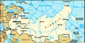
Most of the guide books assume the start of this journey in Moscow, ending in Vladivostok (from west to east). I am going from Vladivostok, on the Sea of Japan, to Moscow, and on to St. Petersburg, where my rail trip will end. This routing will help you determine where I am on this trip. Kilometer notations all start in Moscow. You can do the subtraction if you prefer. Maybe it will help me, too! One Russian fellow on the train hand wrote the stops and kilometers from Vladivostok to Moscow, since he said it was always his dream to do the trip!
Km 9289 Vladivostok is either the beginning or the end of the journey, and one of Russia's largest and strategically important ports.
Km 9050 Spassk-Dalny is where Alexander Solzhenitsyn was imprisoned.
Km 8900 Muravyevo-Amurskaya is named after the explorer and governor of Eastern Siberia, Count Nikolai Muravyev-Amursky.
Km 8521 Khabarovsk was founded in 1858 as a military outpost against the Chinese. Within a few minutes, we will cross the 2.6km bridge across the Amur River. Before the bridge was built, trains had to cross the river by ferry. My seatmate Michael from Zurich boarded
here.
Km 8184 Birobidzhan is mostly swampy taiga, with some deciduous trees in the south. The area is rich in minerals, and the economy is mostly based on wood processing, fishing, and petroleum. The area was originally set aside for Jewish emigration in 1928, though it never became popular.
Km 8037 Bureya is the center of a large gold mining region, and also produces tools for the coal mining industry. You would never know about the gold since the village looks rather poor and simple.
Km 7873 Belogorsk is an agricultural center, founded in 1860, once called Kuybyshevkavostochnaya. This mouthful makes Belogorsk sound boring!
Km 7815 Svobodny is located on the banks of the Zeya River, the Amur River's largest tributary. It became a major railway town with factories building carriages, plus a hospital, schools, and an orphanage all sponsored by the railways.
Km 7602 Ushumun is located only 40km from the Chinese border. It also marks the southern border of permafrost, and tall larches reaching 35 meters.
Km 7306 Skovorodino is named after a revolutionary leader killed here in 1920 during the Russian civil war. It is also home to forestry mills, a
permafrost research station, and a good place to transfer to the Little BAM.
Km 7119 Yerofei-Pavlovich is named in honor of the brutal explorer Yerofei Pavlovich Khabarov. The Urka River runs through town, once a shortcut to the Russian Far East from Yakutsk. The frost here lasts from mid-October to early April, with patches of snow persisting until July.
Km 7010 Amazar contains a large strategic reserve of steam engines. The nearby Amur River flows 2800 km along the frontier with China into the Pacific Ocean at the Sea of Okhotsk.
Km 6906 Mogocha is one of the harshest places on the Trans-Siberian route due to permafrost and summer sun. The nearby town of Olekminsk holds the world record for the widest annual temperature range, from minus 60 C (minus 87 F) to plus 45 C (113 F). Crazy man!
Km 6532 Kuenga was the eastern end of the Transbaikal Railway. The Shilka River is another tributary of the Amur as it forms the Chinese-Russian border for hundreds of kilometers before passing through Khabarovsk. We turn northward form here.
Km 6496 Prilskovaya in gold mining country, as well as silver and lead during tsarist times.
The first convict gangs arrived here in 1722. The Russian explorer, Yerofei Khabarov is said to be buried under the walls of the old church.
Km 6446 Shilka was founded in 1897 and became a popular tourist destination, with ample mineral water to treat digestive and respiratory system disorders. Discovery of gold nearby brought more visitors.
Km 6199 Chita was founded in 1653 and became an important outpost for Chinese trade. In 1827, a large group of Decembrists arrived, and built a prison that would be their home for three years.
Km 5932 Khilok nearing the Yablonovy Mountains, is a small industrial town beside the Khilok River.
Km 5784 Petrovsky Zavod was home to an iron foundry for the region's gold mines. There is a Decembrists' museum here in the former home of Princess Trubetskaya, the first wife of a Decembrist to voluntarily follow her husband into exile.
Km 5562 Selenginsk was founded in the 17th century as a stockade outpost on the Selenga River. The factories here are notorious for the industrial waste dumped into the Selenga River.
Km 5477 Mysovaya was the port where the Baikal and Angara ferries delivered their passengers and their trains. The village surrounding the town is Babushkin, in honor of Lenin's friend and Irkutsk revolutionary.
Km 5358 Baikalsk is said to be the best skiing in Russia, despite the Sochi area where the Olympics were just held. The notorious Baikalsk Cellulose and Paper Combine dumped waste water into the lake, and remains a problem today. But the name Baikalsk should denote our arrival soon at famous Lake Baikal!
Km 5312 Slyudyanka is only 500 meters from the lake, with a stop of only ten minutes, perhaps enough time to run down to the lake and back? The little log cabins along the lake are worth a photo or three.
Km 5185 Irkutsk, known as the "Paris of Siberia" is just 64 km from beautiful Lake Baikal, and my first real stop, for several nights. From here, I will shuttle closer to the lake at Listvyanka, for four nights in this beautiful region. The snow did not help yesterday, however.
See you when I reboard in a few days. It will feel good to walk around for several days, get some exercise, and eat the famous smoked omul from Lake Baikal. So far, the omul has been rather bland.
COMING SOON HOUSE ADVERTISING ads_leader_blog_bottom
Tot: 0.488s; Tpl: 0.011s; cc: 38; qc: 148; dbt: 0.3507s; 1; m:domysql w:travelblog (10.17.0.13); sld: 1;
; mem: 1.5mb