Advertisement
Published: September 21st 2015

 Thingvellir National Park
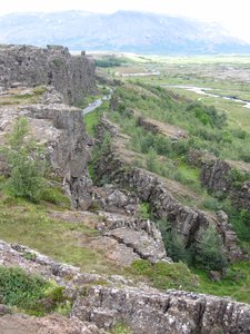
The edge of the North American tectonic plateMonday 3rd August
We flew back from Egilsstadir yesterday morning and in the afternoon I spent a while in the main tourist information centre. The group tour I was on finished yesterday, and all the other members of the group had now left for home, but I had tagged a few days onto my holiday in order to do some sight-seeing around the Reykjavik area. There a half a dozen main tourist companies which each offer various day trips from Reykjavik, with at least 50 different trips available between them, covering pure sight-seeing but also any number of activities such as horse riding, glacier walking, cycling, diving etc. My aim was to spend my last three days seeing as much as I could. In the tourist office I booked ready-made tours for today and tomorrow, and intended to organise my own day on Wednesday.
Today I joined a "Golden Circle" tour. All the tour companies offer this tour, or slight variations on it, which visits three of Iceland's best known attractions over typically a 6-hour coach trip. Our first stop was at the Thingvellir National Park, roughly 40 kilometres from the capital. Thingvellir has two main aspects which put
it on the Golden Circle tour. In about 930 AD it is recorded that a group of local leaders met there to decide on some national laws for the whole country, making it the world's oldest known parliament. However, it also happens to be situated in the canyon (or rift valley) formed by the gradual moving apart of the North American and Eurasian tectonic plates. Our coach next drove to the Gullfoss waterfall. Although not the largest waterfall in Iceland, as well as being fairly close to the capital, Gullfoss is also particularly fascinating to look at because the water falls over two separate drops a few metres apart, with the second drop causing the river to turn at right angles to its original direction. Also, as you approach the waterfall on foot the second drop is not visible until you are almost above it, giving the initial impression that the river just disappears into the ground. From the car park above Gullfoss there is also a good view of the Langjokull glacier a few miles to the north. The third stop on the Golden Circle tour is the Geysir National Park, another geothermal area. It is from this Icelandic

 Strokkur
In the Geysir geothermal areaplace name that the generic word geyser comes. Currently the most active geyser in Iceland is the one in Geysir park named Strokkur which erupts every few minutes. Other variations on the Golden Circle tour add on extra locations, or operate in the evening instead of the day time.
Tuesday 4th August
For my second day trip I had opted to visit the Westman Islands which are about 12 kilometres off the southern coast of Iceland. This would be a very long day trip; my pick up by the tour company from the Kex hostel was scheduled for 7am and I did not expect to be back there until 9:30pm. The trip first involves a two hour minibus ride from Reykjavik to the small port of Landeyjahofn on the south coast. From here the ferry takes about 40 minutes to the town of Heimaey on the Westman island of Heimaey. The Westman Islands consist of about 15 islands (the word 'about' is used as there are some small rock stacks and the actual distinction between an island and a rock stack is not always clear). However, only the main island, Heimaey, is inhabited (though some of the other

 Westmann Islands
Eldfell (on the left) is the currently active volcanoislands do have buildings on them which are occasionally occupied). The only town on Heimaey island is also called Heimaey. The Westman islands were all created by submarine volcanic activity and Heimaey island still has an active volcano. In terms of recent volcanic activity, two dates are particular well known. Before 1963, the Westman group consisted of only 14 islands, but over a period of a few years starting in 1963, a submarine volcano erupted creating the worlds newest island which was christened Surtsey. The eruption lasted for almost four years, after which Surtsey had grown to an area of about one square mile, although it has partly eroded away since. You cannot land on the island unless you are part of one of the scientific expeditions studying its development, but it can be clearly seen, most easily if you do a boat tour around Heimaey. That boat tour, which takes about an hour, was included in my day trip, as was lunch and then a coach tour of the main island.
The second key date in recent Westman Island history was 1973 when Eldfell, the active volcano on Heimaey island, erupted causing the whole population of the town

 Surtsey
The world's newest island, created in 1963to be evacuated to the mainland. That eruption destroyed about 20% of the town of Heimaey but also added a significant area of new land to the island and actually improved the harbour! Also included in our tour was entrance to the museum of the 1973 eruption. This museum has been built on top of and around one of the houses that was buried by the eruption, and that house is the main exhibit. The museum also has lots of information about the island of Surtsey. The Eldfell volcano is only a couple of hundred yards from the museum so I took the opportunity to walk up to the top of it. There was one particular rock crevice on the summit into which I could put my hand but the rocks in there were so hot that I could only leave my hand there for a few seconds. This a clearly a volcano that is still very active! For bird lovers, the boat tour around the island goes up very close to the steep and inaccessible cliffs where thousands of sea birds are nesting. The coach tour of the island also stops at bird observation hut at the southern end

 The Elephant
Rock formation on Heimaey Islandof the island from where puffins can also be observed. All in all, I found this day trip fascinating.
Wednesday 5th August
This was to be my last day in Iceland so I packed my bags and put them into a storage locker at the hostel. My destination for today was the 3000 foot mountain called Esja. Esja is directly opposite Reykjavik, on the other side of the lagoon, so is very popular with local residents. It is possible to reach it by public bus and that was my intention. Unfortunately the timings of the buses to the car park where most walking routes up the mountain start seem to be designed for people intending to spend the whole day there. There are a couple of buses early in the morning, and a couple more early evening, but in between they are very infrequent. From the city centre it is necessary to catch a bus first of all to a suburb called Artun - this bus route (the No. 6) is quite frequent, but at Artun I then had to wait for an hour and a half for the next No. 57 bus to the hiking centre, and

 Heimaey Island
The southern tipit was 12:00 noon before I was setting off from the hiking centre on my walk. Added to that, the day was extremely windy, quite worryingly so, and the higher up I got, the windier it was getting. Quite a few walkers in front of me appeared to be turning back and by the time I got to the large boulder called Steinn, about 200 metres from the summit, I decided that discretion was the better part of valour and started my return.
This was my first visit to Iceland and I thoroughly enjoyed every part of it. It is a fascinating country with amazing geothermal and volcanic landscapes and excellent walking areas.
Advertisement
Tot: 0.248s; Tpl: 0.021s; cc: 10; qc: 49; dbt: 0.1171s; 1; m:domysql w:travelblog (10.17.0.13); sld: 1;
; mem: 1.2mb


