Advertisement
Published: September 3rd 2015

 Husavik
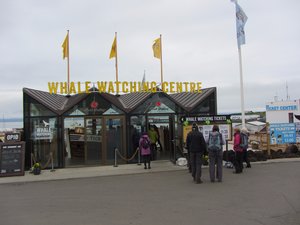
North Sailing whale watching centreSunday 26th July
Our tour guide cooked us breakfast in the hostel at Reykjahlio then we packed and piled back into the minibus for the drive of about 70 km to Husavik. Husavik is a town of 2000+ inhabitants on the shore of Skjalfandi bay on Iceland's north coast. This town is considered one of the better places to see whales because of the variety of different species that are known to frequent this bay and we had a three hour whale watching trip booked for 10 am with the North Sailing whale watching company. The weather was very calm and it only took 15-20 minutes to get to the point well into the bay where we would spend the next couple of hours. There were two other larger boats like ours out there, along with a couple of smaller RIBs.
This was the first time I had ever been whale watching, so I did get to see my first ever whale which was good, but my impression was that there was not very much whale activity going on that day! We definitely saw at least one humpback whale and at least one minke whale, but never more than
one at any one time. It may therefore just have been the same two whales repeatedly diving and then re-appearing. The whales that day were obviously not in a playful mood as when they did break the surface we only saw them for a very short time (30 seconds at the most) before they then disappeared for a dive of up to 5 minutes. The humpback was slightly more interesting in that it normally gave a characteristic flap of its tail fluke before diving, but all we saw of the minke was a small part of its back breaking the surface for a few seconds.
After lunch in Husavik it was back into the minibus for the drive of another 50 km or so around the Tjornes peninsula to the hotel Skulagardur where we would be staying that night. After finding our rooms and dropping off our bags we climbed back into the minibus for the short drive to the Asbyrgi Canyon which is part of the Vatnajokull National Park. This canyon is a natural wonder because it consists of what appears to be a completely free-stranding vertical cliff about 25 meters high. The considered scientific opinion is that
this canyon at one time enclosed an enormous lake but a catastrophic flood burst through and left gaps in the canyon walls. Local legend however has it a bit differently - the canyon walls are in the shape of a horseshoe and was formed when one foot of Odin's eight-legged horse touched the ground. The canyon is also supposed to be one of the main places where the 'hidden people' (or elves) live.
After some time spent walking around the Asbyrgi Canyon we drove back to Skulagardur hotel for our evening meal.
Monday 27th July
The Asbyrgi Canyon we visited yesterday was in the valley of the river Jokulsa-a-Fjollum and this morning our plan is to follow the Jokulsa valley upstream (i.e. south) until we meet up again with National Road 1 and most of this morning's journey will be along a gravel road. After driving for half an hour so along this road we came to the Raudholar and Hljodaklettar scenic area. Raudholar means 'Red Hills' and Hljodaklettar means 'Echo Rocks' and these two are part of a 6 km row of craters which erupted 8000 to 9000 years ago. Since then the river
Jokulsa has washed away most of the softer and looser rock and left a series of bizarre basalt columns twisted in every possible direction. There are many places where you can see views similar to those in Fingal's cave in the Hebrides, but at lots of different angles.
The views around Raudholar and Hljodaklettar were so amazing that we spent quite some time there just walking around and taking photographs. After getting back into the minibus we continued along the gravel road up the Jokulsa valley until we reached two of Icelands main waterfalls, Dettifoss and Selfoss. Dettifoss is the best known of the two as it is much larger and more dramatic than Selfoss, but they are accessed from the same parking area as Selfoss is just a couple of hundred meters further upstream. In fact from Selfoss you can still see the steam rising from the top of Dettifoss. Dettifos is considered to be Europe's 'most powerful' waterfall, however that is measured. In terms of the amount of water going over the top, it is certainly the biggest one in Iceland. As well as the two waterfalls themselves, the river canyon that connects them is also quite
spectacular, with sheer vertical cliffs on both sides. There are north-south running roads along both sides of the Jokulsa valley. We travelled down road 862 on the west side; road 864, also a gravel road, runs down the east side.
After plenty of time to enjoy the spectacles of the two waterfalls we continued south until the 862 rejoins the tarmac road 1 and then followed that for most of the afternoon to the town of Egilsstadir which is almost on Iceland's east coast. Although this is the largest town in the east of Iceland it still only has a population of 2000 or so and in fact was only established in 1947. We would be coming back to Egilsstadir at the end of our trek in a few days' time, but for now we just stopped there for a coffee then left road 1 and travelled to the end of road 94 to the small coastal settlement of Bakkageroi. This is an area that still has a strong belief in elves, and in fact our hotel for the next two nights would be the Alfheimar which means 'elf home'.
Advertisement
Tot: 0.128s; Tpl: 0.015s; cc: 9; qc: 53; dbt: 0.0603s; 1; m:domysql w:travelblog (10.17.0.13); sld: 1;
; mem: 1.2mb


