Greece: Central Greek Rural Rambling
Advertisement
Greece: Central Greek Rural Routes
We’d ordered a car for 2 weeks and promptly headed for Delphi. That bit of our trip we covered
here.
After Delphi, we had no plan. So, this travelblog describes how we experienced 2 weeks without plans!
As always, if you want to see the picture in a larger size, just click on it. Day 1 - Friday June 14; to the hills.
When driving to and pottering around Delphi, we enjoyed the ‘greenspace’. With the daily temperatures increasing, we also liked the cooler air of the mountains. So, having not made a plan, we decided to head up Mt Parnassus and see where the road took us. It was upwards! Delphi is at about 900 metres above sea level, and we headed up to the end of the road at some ski fields at about 2200m.
On the way down (and back in greenery after the nude mountain tops) we periodically stopped to walk through the forests. Both the clean air and the early summer flowers were delightful. At one stop, there was a delightful little alpine church - open for
use!
We continued on and drove through the very pretty Amfikleia, and though it may have been a good stop for lunch we felt it looked too ‘touristic’ (as they say in Greece). Dozens of tables with no one in sight (for us) is not an opportunity.
We continued on, down to the plain. It seems the topography of Greece is a series of quite high and very steep mountain ranges jutting out of almost level plains.
The heat was enough to send us back into the hills, heading to Pavliani. We had a bite to eat before attempting to find the Mt Iti National Park, aka
Mt Oeta NP. Road directions are scant in Greece, and only on the main thoroughfares are there any Roman characters used. We thought we were ‘on track’, only to later learn we were heading in the wrong direction. We saw a track leading into the forest with a ‘home made’ sort of sign to ‘Iron Throne’. We stopped and wandered along a well worn path through delightful ‘bush’. After a long time walking, and with no indicators of how far the site was, we decided to
return to our car.
The time was now 3pm and so we decided to seek accommodation at
Pavliani. After securing a bed for the night, we went in search of the elusive park. We drove through much forest on very dusty gravel roads without any signs that may have given us a clue as to park ‘entry’. Eventually, we decided to call it a day and once on bitumen drove to Gorgopotamous (we loved that name) where we ‘discovered’ a waterfall; a plastic pipe fastened to the top of a rock delivering mountain water. The kids were having a ball with the resultant ‘waterfall’. After a drink, we returned to Pavliani.
Day 2 - Saturday; More green
We’d noticed a sign down the road from the hotel pointing to ‘Throne of Zeus’, it appearing to be a forest walk. We decided the exercise would do us good, so ‘blindly’ entered the dense forest. The path quickly began rising, but at least there were markers to appease any qualms we may have had. We eventually got to the ‘Throne’, to find a wooden hut perched on the mountainside overlooking the town. Inside was a
bed and writing table. The enigmatic ‘Iron Throne’ sign was posted nearby and having confidence in the markers, decided another go was worth the effort. Anyway, we were really appreciating the quietude that the mountains were affording us.
We eventually arrived at the ‘Iron Throne’, to discover it was in fact an iron throne! And, there was us thinking these two ‘labels’ pointed to some archaic relics!
After a few hours of therapy to address a lack of exercise from ‘
too much car sitting’, we headed back to the car. A short walk away was a little park that we’d earlier seen. Entering the park, we found a swing bridge with the boards painted as piano keys. Judy went across first and when halfway over, a loudspeaker began to play a piano concerto!!! The ‘other’ side had some old buildings that had been modified to demonstrate the earlier uses; a water wheel driven saw mill, grain mill and a stone crusher. It appeared the town had developed these for the education of young visitors. We discovered someone had posted a
">video taken with a drone - the vid shows Pavliani in winter, the cool
greenery in summer is sooo different! You can get a sense of the mountainous region of Greece from the video. Upon departing Pavliani, we chuckled at another initiative; the towns folk had painted the sides of rubbish bins and similar with cartoons. Many were devious statements questioning aspects of our daily life.
Taking our leave we headed off towards the next mountain range and a place to stay; Karpenissi. Again, the area is steeply mountainous and hosts a snow ski area.
Day 3 - Sunday; green walk
Near to
Karpenissi is a valley with some wonderfully quaint villages. The locals suggest the area looks like ‘Switzerland’. We beg to differ, but we can see their point; the landscape is not Olive trees but pine!
At the village of Megalo Chorio (big Chorio as opposed to nearby small Chorio), we decided to take another ‘green walk’. This time beside a wonderfully flowing creek (in a dense Plane forest) and onto some paths leading into a Pine forest. Again, the clean air, bright wildflowers and plant scents kept us going.
Back in the ‘big’ village, we devoured some Souvlaki,
Greek Salad and beers!
We just returned to our accommodation before a hail storm arrived. Post storm, we went wandering the Karpenissi village. The cooler air was appreciated.
Day 4 - Monday; Arta
Looking at the map, we headed towards Arta because the road stayed in the mountains. It was a really lovely drive, with an oft changing landscape.
Arta is described in the literature as a town (small city) with an interesting history and off the tourist trail. Arriving in Arta, we were less than impressed at the scruffy buildings We could see why it’s ‘off the tourist trail’. We were thinking only a night, but the hotel we found some 10km out of Arta was so good (and inexpensive) that we booked for 2 nights. It was also in a rural environment with wonderful large trees on the extensive property. We were liking our
move/prop/move approach.
The accommodation offered dinner, which we thought may be a good idea. So, instead of getting back in the car, we just ‘vegged’ out in grounds before enjoying a ‘country’ cooked dinner.
Day 5 - Tuesday; Arta
and the beach
Finding a discarded tourist map of
Arta (in Greek) we were able to walk to the listed places. First was a castle ruins with a huge protective wall that once encircled the city.
As an urban location
Arta has been utilised since the 7th Century BC. It has been over-run several times by Romans, Goths, Visigoths, Normans, Serbians, Ottomans, Albanians, and Venetians.
What struck us most (aside from the lack of publicity about the historical treasures) was the number of extant
Byzantine Churches in the city. The map directed us to five that date back to the 13th century (AD). Each offered a perspective of life back then when the Venetians dominated the region. And, to see 600+ year old fresco’s still on the walls and ceilings was an eye opener for us. While we were not surprised to learn that churches back then were constructed by patrons, St Theodora was interesting in that the bones of the patron are on display and still revered!
Arta is situated on the Arachthos River, and to the north of the city is an old stone bridge. Said to
have been in place from Roman times (and periodically destroyed) the current structure is a 17th century Ottoman
construction .
At about 2pm, rural Greece go for Siesta. Faced with a deserted city, we chose to return to the car and go look at a coastal area; at Koronisia. Not being able to read nor converse Greek, we were at a loss to explain why a government would build a 10 km stone wall embankment causeway to essentially give a few people access to fish traps (and to Koronisia). The village of Koronisia is but a beach town on an island and appears viable for accommodation only in the heat of the year.
Given the heat of the day, we decided to go for a swim. Only then did we understand why Koronisia was (largely) a ghost village - the beach and water wasn’t that great for swimming. Acceptable, but not great!
Day 6 - Wednesday; to the Peloponnese
We’d read that the
Peloponnese is highly regarded for scenery and ancient history. Accordingly, we pointed the car in the direction thereof, joined the motorway and eventually crossed a massive bridge to arrive on
the ‘island’ (which it’s not). After the slow twisty backroads we’d encountered ‘doing’ the mountains, the 130km-ish speed on the motorway was a pleasant change. That said, one doesn’t see much when focussing on a wide strip of bitumen!
At about 1pm, we'd crossed the
monstrous bridge (with it's hefty toll) into Peloponnese and visited the site of
ancient Olympia. Now set in a forest, traipsing around was quite pleasant (despite the heat). Like Delphi, the museum on site has some remarkable pieces on display. Given the setting, and the lack of tourists, we felt this site allowed us the physical and mental ‘space’ to imagine what life may have been like all those years ago. After the hectic pace and the ‘over-run’ by tourists ambience of both the Athenian and Delphi ruins, and this site was a delightful contrast.
We’d earlier decided to try to get somewhere near the
Menalong Trail (in the central part of the ‘island’), so rather than stay overnight around Olympia we drove the extra 1 1/2 hours to Andritsiana; the sleepiest village we’d so far encountered (for lodging).
Day 7 - Thursday; Chasing the trail
From the
various texts we’d been using, we determined the place where we thought it may be good to start ‘our’ walk. The phone satnav ‘accepted’ the name, but as we got close to the area, it started to change directions. The back roads by this stage of our journey were getting narrower, poorly maintained (many potholes), and very windy and steep. The road signage was next to useless. The satnav took us down to the Lousios River (basin) but then instructed us to head up the steep escarpment. We eventually arrived at Stemnitsa, a very beautiful village. By now it was lunchtime, so a bite and a rethink seemed the safer approach. We discovered that the ‘place’ suggested to begin the walk was, in fact, a monastery hanging on the side of the deep ravine! No wonder we got ‘lost’!
With the correct ‘place’ in the satnav, we arrived at the beginning of the track to find an ancient Gortys (Asklepieion in Greek). We learnt that a Gortys was a healing centre with a religious base. This one, beside a brisk flowing river was some 2200 years old. Moving on, we encountered a most beautiful forested gorge with
a refreshingly surgilating stream. When the sunlight filtered through the overhanging trees, the water was a pale Aqua due to the dissolved limestone. The invigorating sound of the water splashing over rocks and little waterfalls encouraged us to progress along the track smartly. At the point we had planned to use as a return point (an old mill), we rested our sweaty feet in the icy water. So cold was the water that the bones in our feet ached.
Moving on, we returned to the car and headed via another route to Andritsiana. Along the way we encountered the castle town of Karytaina. While surprising us as we’d not read anything about it, it was a majestical sight when viewed from the valley opposite.
Our evening meal at Andritsiana was an eye opener. Most towns we’ve visited have a central square where ‘everyone’ comes out to interact in the evening, and maybe have a meal. Adults congregate in groups chatting while kids go beserk on bikes, etc. But, the ‘square’ at Andritsiana is neither central nor large. With almost no cars travelling through, and no footpath (to speak of) people just congregate on the
road wherever they please. It amazed us to see folk sitting on chairs in the middle of the road seemingly not caring much about potential traffic!
Day 8 - Friday; Apollo, the Monastery and Sparti
We’d decided to go back to the gorge near Stemnitsa to visit a very old Monastery we’d not had time to visit, and also an old stone bridge we’d ‘missed’ at Karytaina. But, as we were leaving, our hotel host asked whether we were going to visit the Temple of Apollo.
Mmmmm????? We’d missed the literature on this one!!!! Being only 30 minutes away, we headed to the
Temple of Apollo Epicurius at Bassae. We were stunned at the site. The temple had been re-assembled and was housed under a giant tent. Apparently, due to the isolated site high on a hill with no village/town nearby, the stonework was nearly all in situ. The site wasn’t a multiple of buildings (like Delphi or Olympia, etc.), but just the foundations of an early temple site, and the later 6th Century BC one (now re-assembled).
Back in the car, we went looking for the old stone bridge over the River Alfios beside Karytiana.
The bridge, a Byzantine structure, included a small chapel. We wondered whether the local ‘lord’ extracted taxes to enable a crossing, and the fleeced folk went in for moral support (we lost the pics we took so look
here..
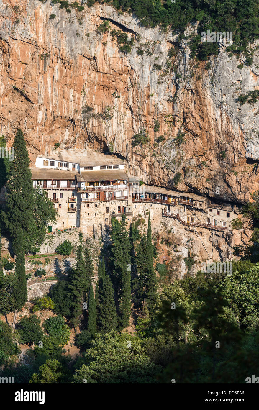
We continued on the monastery; Mone Agiou Ioannou Prodromou - or the Monastery of St John the Baptist. The only way in was via a steep but well maintained path. All the goods needed arrive by Donkey! The ‘attraction’ was the 11th century Byzantine Chapel partly carved out of the rock wall, and the building itself clinging to the sheer walls. This was one of several in the area, and many throughout Greece. We learnt that the remote location was an outcome of 2 attributes. One, since earliest times, monasteries were perceived to be located in isolated places. This became an edict after the direction of Emperor Theodosios 1st. And, two, during the Ottoman ‘occupation’, only those monasteries in remote places were left to proceed without imposition. Thus, this monastery represented a long lived culture.
We entered and a priest welcomed us, showed us the chapel and made us a cup of Greek coffee with
‘home made’ biscuits. He was at pains to make us know that the coffee was ‘free’ and he would not receive donations!
Taking a photo to show the extent of the monastery is nigh impossible. We used a net photo sourced from
here We returned to the car and headed to Megalopoli (for lunch and a break), then on to Mystras via the nearby Sparta (they write it as Sparti).
Day 9 - Saturday; Mystras
The Byzantine hilltop fortification town of
Mystras was the destination for the day. Constructed as a settlement fortress in the 12th century by Prince William II Villehardouin; a Crusader at the (1st) fall of Constantinople. Though enduring various intruders (
as most places in Greece appear to have encountered), it was always a Christian stronghold. Even under Ottoman occupation, the Christians were allowed to continue without hindrance. Several of the churches were even constructed with Muslim help. The relevance of this point (Christian churches) is that several have fresco’s lining the walls and ceiling intact from 12 - 14th century. Apparently, these are the reference ‘points’ for extant fresco’s elsewhere in Europe.
We
learnt that in 1834, residents were encouraged to move to the newly constructed city of Sparti (Sparta). In 1922, the Greek government determined that the site be declared an historical asset and the few remaining residents of the site were removed in 1954. Apparently, those few 'remainders' were Turkish descendants eking out a living after the Ottoman administration had been sent packing. Now, the site has World Heritage
status. The monastic priests were also asked to find new quarters.
Set on the side of the (typically Greek,
steep!) hill, the pathways between the various buildings (primarily monastery churches) was challenging. Most still retained the stone cobbles which, with wear are slippery. We opined that life here then would have been largely for the fit. We wondered what would have happened for the lame or infirm.
Each of the churches had some special feature that made the visit (extra) worthwhile. At
Pantanassa Monastery, the resident caretaker had a flair and the entry was laden with pots of flowering plants - now in bloom. The colour and perfume made for a wonderfully special dimension.
On the top of the hill was the castle; largely
a defensive structure and place of last refuge. Near to the top was the palace used by successive rulers. The last to use it was a Despot. From ancient times, in Greece a ruler not elected was a tyrant - and there were
many). A tyrant from the Balkans was named a
despot. The building is now referred to as the Despot’s Palace. It had deteriorated considerably in places, but refurbishment is now almost complete. If the reconstruction is true to original, the rulers certainly lived in style. That said, we were told that Mystras itself was always a seat of artistic creativity. Most residents earnt income from art (in one of the various forms).
The day was predicted to reach mid-30’s, so we arrived early and by midday had viewed all but the castle. Judy suggested we return to our digs and await the cooler part of the day to return to inspect the castle (it having a separate roadway entrance).
After a shower and rest in the air-conditioned apartment, we again headed up the mountain. The castle complex had been well destroyed and essentially, was impressive only when looking at it from
the plain below. That said, the ruins still provided a good view of the plain below, and offered an insight into the hardship that would have befallen those trapped inside when an enemy threatened.
We’d gotten used to the rural Greek practice of siesta between 2 and 5, and dinner from around 9pm. Earlier in the trip, we’d made the error of proceeding to have an evening drink at around 5, only to ‘fill in’ time by enjoying an extra drink or 5! So, tonight we headed to Sparta later. Like so many towns we’d visited, the central square was now ‘conversation’ central. And, kids were having a ball on roller skates, bikes, skateboards, etc. This ‘communalism’ is a delightful aspect and quite missing in Australia. It would be great if Australian’s could let go of the use of fear as a tool to separate from others, and allow kids to be kids!
Day 10 - Sunday; Tripoli and Nafplio
We’d read and heard positive comments about Nafplio, so for our last night in rural Greece decided to head there.
Along the way, we deviated into Tripoli to get a
cup of (decent) coffee. Greek coffee - water boiled with coffee and sugar served in a small cup - while tasty, doesn’t equate to a long black or flat white. Hotels tend to only offer instant coffee, so a morning ‘fix’ was needed.
Tourism seems to have avoided the agricultural town (city?) of
Tripoli. But, on a Sunday morning the central square had enough folk enjoying coffee for us to do the same. We liked that Tripoli is the capital of a region known as Arcadia. We wondered whether the Greeks place the same emphasis on Arcadia as used in the English language.
The route to Nafplio covers some remarkably dry and hilly terrain. Fortunately (for us), the main road has been constructed to avoid the twists and turns evident on other hilly terrains.
Sitting on a natural harbour behind a quite steep hill,
Nafplio has been an important seaport for many centuries. Successive rulers have had castle forts erected on the top of the hill such that they appear foreboding on the ‘old town’ below.
Now quite touristy, the centre of the ‘old town’ has largely been
pedestrianised. As well as many restaurants and up-market shops catering to the tourist clientele, the ‘old town’ also hosts an old mosque converted into a hall that was used for the first Greek (Hellenic) State parliament.
After securing accommodation, we wandered the streets and discovered a little island off the harbour shore. We learnt it was used as an anchor point for chains that were strung between the ‘mainland’ and the island to prevent entry to ships deemed ‘off limits’. The island is heavily fortified and has the dubious reputation of being where convicts lost their heads!
Day 11 Monday; the end
Today was a return to Athens for our departure home on Tuesday morning. Rather than do what locals do - take the motorway and a 2 hour trip - we took the coastal road with the scenic view.
With a car until the morning, once we’d arrived at our accommodation we returned to a central Athens pub we’d previously enjoyed for an ale or 2. Then, to the central market area for a delightful meal in a deli.
Reflections
In the main, we purposefully took
the road less travelled. And, we were delighted with the result (for us).
We were surprised at the quality of the roads. From the super-swish tolled motorways, to the regional arterial roads and minor back roads, rarely did we encounter much traffic. And, aside from poor construction of roads in the mountain areas (construction graft?), nearly all were well maintained. On this, Australia could take a lesson!
The landscape is hard to describe to anyone not having been to Greece. For the parts we travelled, the mountains rise steeply up from plains. But, typically, they don’t just ‘rise steeply up’, they more jut up in dramatic fashion. We likened the rise like a pod of Humpback whales reaching up out of the ocean; it’s either a flat(ish) landscape or soaring mountains. In some areas, the vegetation was dense and green, others the soil type (and goats) restricted all but a few weeds. Rarely were there wide pastures. On the plains and up into the mountains, Olive trees are everywhere. On the fertile mountains, the vegetation is largely Pine plantations. Where not plantation, the vegetation is lowish scrub. We wondered whether Greece ever had any
indigenous large trees, they are certainly not evident now.
We were not impressed with the lack of support given to the independent traveller by either the (central) Greek government or the local administrators. Typically, to a more or less degree, the countries we’d visited gave assistance at least in the form of literature. Not so Greece. If tourism is an industry the nation wants to encourage, they are not helping themselves. Even in the ‘pay for entry’ historical sites, the support offered is scant. Thank goodness for smart-phones and Wikipedia.
As noted in an earlier missive. We really appreciated that fruit (especially) and vegetables were marketed when ripe. A tomato in a fruit stall was ripe to eat, as were peaches, cherries, etc. For a couple of Australians fed on product picked green and gassed to encourage colour, the taste of ripe F+V was sensational!
Perhaps the most enduring legacy from our trip is the almost universally kind nature of the Greek people. Motorists go out of their way to give courtesy (something Australian’s gave up too long ago). And the Greeks we met were mostly very charming and courteous in
the way they engaged with us. With a quite different disposition, we now understand why Greeks are unsupportive towards the Syrian and Nth African refugees. We chuckled when we encountered some Greek men getting upset at something; they’d carry on vociferously for ages. We understand that Greeks can hold a grudge - that’s human. Even after ‘words’, the Greek people we saw appeared to just give up and walk away with a ‘what’s the point’ attitude; and once they’d decided it’s over, it was over!
Next, New Zealand!
Advertisement
Tot: 0.238s; Tpl: 0.025s; cc: 10; qc: 24; dbt: 0.0596s; 1; m:domysql w:travelblog (10.17.0.13); sld: 1;
; mem: 1.2mb


