Advertisement
Published: January 27th 2009
Worth the Wander
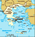
After the last entry, you may be wondering what possessed us to go creeping along the winding, collapsing mountain roads of Crete. Brother Mark and I were looking for a small beach town on the Southwest coast called Sougia because it was the closest thing we could identify near Lissos. Lissos is an ancient site that's played host to a number of civilizations. The odd thing about Lissos is that, while it's marked on lots of maps (usually with a cartoon symbol that's supposed to suggest ancient ruins), there's almost no information about it anywhere and there's no road to it. That's going to peak my interest; but how to get there? We had a plan for trekking across Crete. Before you point out that Ernest Shackleton had a plan for trekking across Antarctica, let me point out that poor Shackleton didn't have Frewin Poffley, or he might not have ended up crossing Drake Passage in a leaky rowboat.
Frewin Poffley is a travel writer specializing in Greek island hopping. He has an ingenious system that overlays different ferry schedules in a graphic format delineating them by reliability. This is the key to Frewin's system because,

 Waiting for the Ferry
Sooner or later, you will get stuck waiting for a boat that may never come. Some of these people have been waiting two days.no matter how carefully you plan, you're going to get stuck somewhere. A catamaran is going to cancel because of the Mediterranean winds that famously pick up without warning, or a ferry is going to get triple-booked and you won't feel like spending nine hours holding your spot on three square feet of sun scorched steel deck. A commercial captain may get arrested or decide to detour to see a girlfriend on Mikonos, leaving you waiting on Thira. Come to think of it, there's a lot to be said for traveling the islands with no plan at all, just a desire to wander and a copy of Frewin's Greek Island Hopping. Mark and I call him "The Brit." When in doubt, go to The Brit. If you like to travel without a fixed itinerary, you want The Brit. If your goal is discovery and you like to change directions on a whim, you need The Britt. He publishes an updated guide every year that is a must for independent travelers in Greece.
For driving on Crete, you're going to want to pick up the big blue book that says Crete on the cover in big, proud yellow letters. It
will be on sale wherever you see a newsstand and includes the best available roadmap. Notice I said "best available" roadmap. It's not perfect and it's not up-to-date, but it'll do. Even if someone ever does get around to updating it ("it can wait"), no cartographer no matter how creative could take into account that no three Greeks on Crete can seem to agree on what to call a given town, how to pronounce it, or even how to spell it. Road signs, even those that aren't hidden behind a pile of rocks or were knocked down by the Nazis, tend to alternate names and spellings. Three signs in a row marked Hania, Chania, Xania, all refer to the same place. Two signs in a row, both marked Agios Nicolos, may refer to different places. Two towns so near each other that there should be a road between them may have one after all, it's just not in the book. A road indicated on the map will probably be there, but you should look at some of the pictures in the previous entry and think "alternate route."
Back to our plan to drive across Crete. Our plan, such as

 Harbor at Chania
The harbor at Chania is the site of the evening promenade, when the locals take turns walking past each other.it was, was to get to Sougia, find a place to stay for a couple of days, and just ask around about Lissos. Okay, that was my plan. Mark has no interest in "staring at a bunch of old rocks and broken plates in field ." He has yet to forgive me for making him detour to Knossos and maybe he never will. Mark's plan was to hang out on the beach and maybe catch a bus to Sumaria Gorge. As it happens, I found the way to Lissos and Mark got off the bus at the wrong gorge (Crete has any number of gorges). Even if I hadn't found Lissos and even if Mark hadn't learned the hard way that one gorge looks very much like another, it turned out that Sougia is a terrific destination in and of itself. We both ended up back there a year later. Mark's efforts at seeing Sumaria Gorge were thwarted again, this time by the intense August heat (they closed a natural feature due to heat, if you can believe that). I made a second visit to Lissos and Mark got to see it this time. I'll go back a third and

 Rethymno
Wandering around the streets of Rethymnofourth time if I can. Mark still wants to see Sumaria Gorge, or "the gorge that fate will not allow Mark to see" as I have come to think of it.
I said Sougia is worth the trip by itself and I'm going to tell you why I say that, but first I have to give you some hints as to how to get there. From Iraklio (or Heraklion), you have to take the New National Road headed West and pass Rethymno and Chania. Actually, don't pass either. Stop and stay at least a night in both, but that's the subject of another entry. Leaving Chania in the morning allows you to make the drive across the mountains in daylight, allowing for some getting-lost time. Continuing on, a little after Metochion, look for an easy-to-miss exit marked (hopefully) "Vlacheronitissa." If you get to Dempla, you missed it. From this point on, consult the big blue book. The path is generally Sirilio, Elliniko, Limni, Tomadiana, Nea Roumata, Prassas, Prines, Moni. After Moni, the road winds down the mountain side, passes through the town of Sougia, and dead ends at a rocky beach. When I say drive carefully and only during

 Sougia from the Harbour
The one road to the town can be seen snaking its way down to the beach.daylight, I mean it. Refer to some of the pictures in the entry on Crete Driving Tips for a good idea of road conditions. You will wander through countless mountain towns that you would think were totally uninhabited were it not for the collection nets under the olive trees.
So, why go all way to Sougia, anyway? The point of going to Southwest Crete was to avoid the cruise ship destinations and all-inclusive vacation spots. Sougia is the perfect opposite of all those things. It's a real get-away-from-it-all location. People camp on the beach under the trees for weeks at a time. Children can run wild because there's really nowhere they can go. The nude beach is located at the far eastern tip behind a huge rock that juts out of the surf. Right where the road through the town ends, to the right, is Cafe Lotos for good light food, internet access, and Joseph, the guy that will tell you how to get to Lissos. Across the street from Lotos is a convenience store that sells a variety of things including the kinds of things people who weren't planning on camping under a tree for a week might

 The Gorge to Lissos
Mark was kind enough to act as scale figure.need if they suddenly decided to; also the town's ATM. There are plenty of tavernas and pensions where you can get a room for twenty or thirty Euros depending on if you want air conditioning. In July you may go without the air conditioning, but by August the temperature may turn so oppressive that even the flies are somnambulant and gasping. You don't have to swat at them. You can pick them up off the table with a napkin and drop them on the floor. For a little more info on Sougia, check out www.sougia.info/
On arrival, we secured a couple of beds and headed down the main road to have a look around. We plunked down in Cafe Lotos and, after a little while, a tall thin Greek came out from behind a door. On the back of the door was a poster of El Capitan in Yosemite Valley. Meet Joseph, not your typical Greek taverna guy. Joseph is a passionate rock climber and retired tower crane operator. Just ask him and he'll pull out a photo album full of hair raising pictures of the kinds of things he's had to do with a crane to get a
job done. In the US, you simply would not be allowed to weld two cranes together to reach on monastery carved into a cliff. In Illinois they call that reckless endangerment, in Greece they call it problem solving.
Getting to Lissos:
Take the beach road west to the little harbor at the end and look for a path that leads off to the right into a gorge. Follow the little piles of rocks that people have left to find the way. Don't trip over the goats. About a quarter mile in, on the left, there's a goat path that winds its way up to the plateau above the gorge. Across the windswept plateau covered with stunted scrub, the path is pretty easy to follow if you stick to the well-worn rut carved out by the feet of hikers and, of course, more goats. On the other side is a valley, amidst the goats is Lissos, It's quite a climb down (and an even tougher climb up), but if you are up to it, down in that valley is a amalgamation of Minoan, ancient Greek, Roman, Byzantine, and modern Greek remains all piled on top of each other, scavenged

 Follow the Goats
Looking back down the twisting path up to the rim. from one another, and half buried in the hillside. Here I have to let the pictures do the talking. You can also arrange to get to Lissos via boat. Look for The Captain George and inquire, but Captain George charges an extortionist rate for those who don't want to make the climb.
Advertisement
Tot: 0.109s; Tpl: 0.014s; cc: 12; qc: 53; dbt: 0.0612s; 1; m:domysql w:travelblog (10.17.0.13); sld: 1;
; mem: 1.2mb


