Gibraltar Geography, Gibraltar Geography
Advertisement
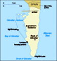
Location: Southwestern Europe, bordering the Strait of Gibraltar, which links the Mediterranean Sea and the North Atlantic Ocean, on the southern coast of Spain
Geographic coordinates: 36 8 N, 5 21 W
Map references: Europe
Area: Total: 6.5 sq km land: 6.5 sq km water: 0 sq km
Area - comparative: About 11 times the size of The Mall in Washington, DC
Land boundaries: Total: 1.2 km border countries: Spain 1.2 km
Coastline: 12 km
Maritime claims: Territorial sea: 3 nm
Climate: Mediterranean with mild winters and warm summers
Terrain: A narrow coastal lowland borders the Rock of Gibraltar
Elevation extremes: Lowest point: Mediterranean Sea 0 m highest point: Rock of Gibraltar 426 m
Natural resources: None
Land use: Arable land: 0% permanent crops: 0% other: 100% (2001)
Irrigated land: NA sq km
Natural hazards: NA
Environment - current issues: Limited natural freshwater resources: large concrete or natural rock water catchments collect rainwater (no longer used for drinking water) and adequate desalination plant
Environment - international agreements:
Geography - note: Strategic location on Strait of Gibraltar that links the North Atlantic Ocean and Mediterranean Sea
Advertisement
The information here has been derived from Public Domain Sources such as the CIA World Factbook. No liability can be taken for any inaccuracies.
Tot: 0.046s; Tpl: 0.007s; cc: 3; qc: 10; dbt: 0.0157s; 1; m:domysql w:travelblog (10.17.0.13); sld: 1;
; mem: 1.1mb
 Strategically important, Gibraltar was ceded to Great Britain by Spain in the 1713 Treaty of Utrecht; the British garrison was formally declared a colony in 1830. In referendums held in 1967 and 2002, Gibraltarians ignored Spanish pressure and voted ...