Advertisement
Published: December 19th 2007

 The "New Bridge", Ronda
A bridge only 250 years old qualifies as new infrastructure in a town with roots as ancient as Ronda's.The weather was good and we probably could have ridden up to the historic town of Ronda from Granada, but there wasn't much to interest us between the two destinations, so we took another of Spain's efficient and comfortable trains to get to our next cycling point.
Ronda turns out to have historical interest due to its strategic location on top of impregnably shear cliffs at the edge of a roaring river gorge, and current interest because the Rondianos are playing it up for all its worth, charging admission fees to the most mundane of attractions. I did pony-up ?6 to see their bullfighting museum, as Ronda's Romero dynasty of matadors holds the claim to having developed the "modern" technique and style of bullfighting, which made an arena sport out of what had previously been the somewhat dangerous (to the populace) pastime of chasing and spearing maddened bulls running loose in the city streets.
Ronda also has great medeival ruins - walls, bridges, an Arab bath - as well as their "New Bridge" (only 250 years old) spanning the great gorge, so we found enough to do in Ronda to spend a couple of nights before setting out on
Gaucin, Spain
A stop on our ride from Ronda to Gibraltar. our ride to Gaucin, the next stop on our way to Gibraltar and Morocco.
Gaucin appeared to be only about 35 km from Ronda - downhill we presumed, towards Gibraltar - so we chose a more roundabout route that took us off the main highway with a detour to see a modestly famous local attraction, paleolithic cave paintings in a limestone cavern. Well, we missed the cave tour by a half hour and ended up adding 300 meters of climbing to what was already decidedly NOT a downhill run to Gaucin. We rejoined the main highway, and after another 25 kilometers of coasting down and then grinding our way back up in the granny gears we arrived in Gaucin pretty wiped out. Kate had nursed a cold through Seville and Granada, and that night it hit me too, so being the wimpy patient I decided to take a sick day in the very comfortable Hotel Caballos Andalus, working on the free wifi connection and Skyping home to the family at night. In the late afternoon we caught our first glimpse of the Rock of Gibraltar, 60km distant, poking up above the hazy horizon.
While the following day's ride
Gibraltar view, 60km to the south
Our first glimpse of Gibraltar as seen from the town of Gaucin, Spain. was still a bit bumpy, it started off through what could easily have been mistaken for the California coastal range and a smoking 12km downhill that was like La Honda Rd. with twice the length, twice the descent, and twice the number of motorcyclists (it was a Sunday morning, after all.) We continued to roll through orange groves towards the Mediterranean until we started to hit the Costa del Sol golf course/condo zone. We'd requested a "bicycle route" from the GPS and it found us grade-separated bike paths - very clearly a quid pro quo from a developer, SotoGrande, to the local authorities - for a winding 10km to connect with the busy Autovia highway. But then we had to bite the bullet and ride on the highway shoulder - glad we didn't do that all the way from Malaga! - down into the border town of La Linea de Concepcion.
We'd decided to stay in La Linea, on the frontier with British Gibraltar, because while we wanted to VISIT Gibraltar we'd been warned that it was a really charmless, expensive place to eat and sleep (true.) While La Linea didn't have much going for it in the charm
dept either, it was cheaper than average for Spain, and we could walk (ride, actually) across the border from our hotel.
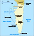
The next day we did just that, crossing the border by bike, with a border control protocol that consisted mainly of a bored wave. Then we cycled across the international airport runway that neatly bisects Gibraltar's only land access to the rest of Europe. A half dozen flights - scheduled airlines, military planes and private jets (Gibraltar is a big tax haven) - land here each day, and as we saw during the evening rush hour, the airport authorities simply drop crossing gates across the highway and let traffic build up on both sides until the planes have landed and taxied back to the terminal. Once the gates are raised again it's like the Red Sea surging back in, a complete free-for-all of cars, motorcycles, bikes and pedestrians racing across the 1/4 mile-wide runway.
Gibraltar is truly a nightmare of urban planning, but we managed to ride the entire 10km length of the peninsula, past the town centre, the condo developments, yacht harbors and the industrial container port and out to the Europa Pt. lighthouse without being
Europa Pt Lighthouse, Gibraltar
This lighthouse at the furthest southern tip of Gibraltar is within sight of a large mosque and a wrecked oil tanker. Coincidence? sideswiped by a scooter or flattened by a lorry. Ironically situated in shallow water right off the lighthouse is the recent wreck of an oil tanker, and across the road from the lighthouse is a mosque said to be the largest in Europe. (We'll leave the symbolic interpretation of this eco-geo-religious confluence up to our readers.) From Europa Pt. we ground our way up the serpentine roads (and paid our 8 Gibraltarian pounds) to see the Rock's various points of interest: St Michaels Cave, an amazing limestone cavern transformed into an auditorium, the "siege tunnels" dug by the British during the 18th century assault on Gibraltar by the French and Spanish, various gun emplacements, heritage museums, etc. We got surprised looks from tourists emerging from the tramway cable car that we'd managed to ride our bikes up the knife-edged ridge road to the highest observation point on the publicly-accessible part of the Rock (Gibraltar is still very much a British military base.) Clearly visible to the southwest were the looming Rif mountains of Morocco, our next day's destination. We beat it back down the hill close to sunset but couldn't manage to avoid getting caught in Gibraltar rush hour traffic,
normally terrible due to the territory's bottlenecked access but this day exacerbated by the 5:30PM arrival of a scheduled commercial jet flight.
Spectacular views and challenging biking made for a memorable day, and we retired early in order to get a jumpstart on the next day's ride around the bay to the nearby port of Algeciras, where we'd catch the ferry for North Africa.
----------------------------------------------------------------------
Check our expanded gallery of travel photos at:
http://www.flickr.com/photos/steve_hoge/collections/72157613626339376 And visit our home page at:
http://web.mac.com/steve_hoge
Advertisement
Tot: 0.155s; Tpl: 0.011s; cc: 16; qc: 74; dbt: 0.0751s; 1; m:domysql w:travelblog (10.17.0.13); sld: 1;
; mem: 1.3mb