Advertisement
Published: June 27th 2017

 IMG_7715
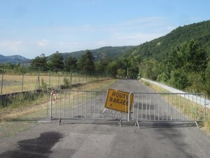
Not a promising start to the dayWith rumours of afternoon rain circulating, I headed off early in hopes of avoiding it, and as a consequence also enjoyed relatively cool temperatures to start with. I was a bit concerned when early on I found the road I was supposed to turn down was blocked off, but riding around the barriers was really easy and the warning of road closure proved quite irrelevant. With yesterday's tailwind persisting, the day was starting off extremely well.
After crossing the dam I expected us to follow the road along the river so I was quite unprepared for the 1st-gear climb that I was directed to, and further dismayed to discover that whereas the distance to Valonne posted at the roundabout was 8 km, the sign uphill and around the corner from it claimed it was 9km away; if that sort of thing persisted I might never reach it at all. At the top of the climb the announced distance had reverted to 8km, and as things levelled out along a bench it was clear sailing past orchards and fields of grain - except for when a deer rocketed out of the woods in front of me, just about t-boning the truck

 IMG_7718
Looking back at Sisteron from across the riverI was following. There followed a magnificent downhill coming off the bench, then a brief stretch through a little gorge before crossing back across the river and joining the main road. I ended up getting stuck behind a tractor that was moving slightly slower than I had been, but traffic was heavy in both directions making it hard to find an opening where I could pass, so I let myself be motor-paced for a bit (not recognising the tractor's speed would remain constant, I foolishly struggled to keep up on an uphill and subsequently had to brake going down the other side.)
We pulled off the main road at Malijai heading towards Puimichel, and the initial 9km climb was absolutely delightful - at a steady 5% not too onerous, but quite desolate and tranquil with birds chirping and hardly any traffic at all - before reaching the top I was passed by only 2 cars and 1 cyclist, and encountered but 2 cyclists, 1 car and 1 truck heading towards me. Mind you, the road was narrow and there was not much room between the truck and me when he went by. Although I didn't notice a col sign

 IMG_7720
The view along the bench(our trip notes don't actually mention a col at this point) apparently there was one wrapped around a pole somewhere. In any case, once over the top we emerged to find fields of lavender awaiting, and after reaching Puimichel itself were treated to a descent that seemed like it would go on forever.
Of course it eventually had to come to an end, and after turning off it and climbing briefly, what I thought to be a ridiculously pleasant country lane unfolded before us. That was before it delivered the 3km lung-busting climb to Entrevennes, where I paused to have a snack and discovered that the "burger" I had purchased at the patisserie in Sisteron turned out to be fish. At any rate, thus replenished I resumed climbing into the sun, only this time thankfully along a much reduced gradient, eventually emerging on a flat plateau before quite literally bouncing down the switchbacks to the sound of countless shrieking cicadas. The steepness of the road and the tenuous contact with the pavement combined to make the descent quite nerve-wracking.
4 km of now-mercifully flat but still bumpy pavement later we turned off again headed for Brunet, which was

 IMG_7725
My pace tractorwelcome even though it was more than apparent that another climb would be required inasmuch as it was on a smooth road. The climb to the town proved much easier than one would have suspected from looking at it, but beyond that the road really pitched upward and it was so demanding that I actually rode on the wrong side of the road for a bit to take advantage of the shade offered by the hillside we were traversing. Eventually, though, the road topped out to reveal a wide and expansive plain that provided what at first seemed like a refreshing, evaporative wind and which several km later, of course, turned out to be just another impediment to travel.
Eventually we dropped off the plain and corkscrewed down through Valensole (sorry, because of traffic I was unable to pull over and grab a photo) and immediately up (of course) the other side of the valley towards Riez, along a smooth and wide road that was fun to ride as it swooped up and down and wound around itself. before ultimately descending into town (and I only had 1 oncoming car encroach into my lane on a switchback on the

 IMG_7727
Hedaing off (up) to Puimichelway in). I filled up my water bottles in Riez and consulted the map while I ate: there were still a few squiggles left on the road we were to take (indicating an elevation change), which didn't bode well as I struggled to get my legs back after lunch, all the while noticing clouds building behind me.
After a long slog on a false flat I was surprised to find that there was not a climb to Moustiers-Sainte-Marie as I had anticipated, but a huge descent prior to what was just a slight uphill section that skirted most of the town (which was higher) before dipping downward yet again (enough that I pulled over to let traffic in front of me continue since it was slowing me down). By Saint-Clair it was starting to spit, and with another 10km to go I wondered if I would make it in before getting soaked.
As I descended further to the Lac de Sainte Croix, though, the rain (such as it was) stopped and so did I - taking advantage of the opportunity to take some requisite photos. But as I continued around the lake the rain picked up again -

 IMG_7730
The view part way upwhich made sense inasmuch as I was now heading back into it - and I was still holding out hope of arriving relatively dry when I came across fresh pavement (French technique being what it is, the road is actually rougher when freshly laid than it is after cars have gone over it for a while, so this slowed me down a bit) and soon the paving crew itself, who were controlling access to the single lane that was open. Fortunately I didn't have to wait long and made it to the hotel just as the rain started to come down more seriously, albeit only for a brief period before stopping entirely. Since it was only 2:00 and the van hadn't yet arrived there was nothing to do but have a beer.
All in all it was pretty damn fine day.
Advertisement
Tot: 0.349s; Tpl: 0.012s; cc: 9; qc: 28; dbt: 0.0398s; 1; m:domysql w:travelblog (10.17.0.13); sld: 1;
; mem: 1.1mb


