Advertisement
Published: December 11th 2009
These are the captions for this album: http://picasaweb.google.com/schmitt.dick/TheDefensiveWallsOfDubrovnikCroatia?authkey=Gv1sRgCPun7on-t_qangE#
It makes a lot more sense to see them by clicking on the link above
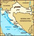
Day or night, by land or by sea, Dubrovnik's walls are highly visible as one approaches this historic city. One of the strongest set of fortifications in Europe, these were never breached. The town fell only once, when that rascal Napoleon and his buddies were invited in to help defend -- and decided to stay and take over the place. (Oh, those French!) But to a large degree, Dubrovnik's best defense were the skillful diplomats who played the city'-states's enemies off against each other such as the Venetians and the Turks. (Diplomacy sometimes consisted of paying tribute -- and bribes -- to each of those countries as well.) At the rear we see the Croatian coast -- only about 4 miles wide at this point. Over these mountain lies Bosnia and Herzegovina -- land of the Ottoman Turks until 1878
Here's another view: the dark green blob was for four centuries the Ottoman's westernmost province: Bosnia, which hovered just over the mountains from the skinny republic of Dubrovnik shown in magenta. Pale green
Venice encroached with its string of islands and shoreline colonies creeping like a snake on the northeast shore of the Adriatic. For citizens of tiny Dubrovnik, good fences, and diplomacy, make good neighbors. (Thanks to the University of Texas for putting this map into the public domain.)
These walls were a long time abuilding and today are superbly maintained and make for a pleasant walk. These replaced previous defenses and were built and rebuilt from the 11th to the 14th centuries as the city expanded. The Turk threat starting in the 15th century gave Dubrovnik, like much of southern Europe, a strong incentive to further fortify their defense, especially on the land side. Work continued into the second half of the 17th century. Here we climb towards the most significant land defense, the Minceta Tower. Note in the background we see a lower wall -- it's separate from the original wall and is meant to take the hit of an artillery attack while keeping the tower defenses intact. It's known as a scarp wall.
Here's an outside view of the stone wedding cake known as the Minceta tower -- the design of one of Florence's most famous Renaissance architects: Michelozzo di Bartolomeo Michelozzi, builder for the Medicis. As a sculptor and collaborator with Donatello, Michelozzo did subtlety. But as a defensive architect, he did force as well. When both Constantinople and Bosnia fell to the Ottomans in the mid 1400s, Dubrovnik knew it had to strengthen the town's highest spot owned by the Mincetic family. They invited Michelozzo to design this and several other fortifications. He placed this round middle section with 20-foot walls above the existing 4-sided fort built in 1319 and integrated it into the scarp walls.
Here's a southwestern view of the Minceta tower which should be called "the sculptor's tower". This utilitarian structure was created by master sculptors of both the Renaissance and Gothic eras. After Michelozzo, work continued by a Venice-trained sculptor and architect from the Croatian city of Zadar named Juraj Dalmatinac (or in Italian, Giorgio da Sebenico.) Dalmatinac was not quite the Renaissance man like the Florentine Michelozzo. He's best known as a medieval sculptor and his masterpiece is the Gothic cathedral (and UNESCO World Heritage site) in his home town of Šibenik where, incidentally, he received the greatest homage a sculptor can get: Ivan Meštrovic created a sculpture of him in front of his masterpiece cathedral.Construction completed in 1464 -- since then it has been a symbol of the impregnability of Dubrovnik.
A small harbor sits as the western ends of the town and it's protected in the distance by both a stand-alone fort called St. Lawrence (Lovrijenac) and, in the foreground, by another round Michelozzo fortification extending from the city walls called Fort Bokar.
The smaller harbor (called Kolorina) is protected by St. Lawrence Fortress (Lovrijenac) at left and the Bokar cylindrical tower at middle.
Rising over 100 feet above the sea, St. Lawrence Fortress (Lovrijenac) appears impregnable from both land and sea. Venetians tried to build their own fort here in the 11th century. Had they succeeded, Dubrovnik would have been their colony. Dubrovnik beat them to the punch, erecting a fort in three months -- in time to greet the ships laden with construction materials arriving from the thwarted Venice. The present footprint dates from the 14th century but it was modified in subsequent centuries including after the 1667 earthquake that devastated Dubrovnik.
Built triangular in shape to fit its rocky underpinning, Fort Lawrence (Lovrjenac) is known as Dubrovnik's Gibraltar. The rock base is not level -- creating the need for the three terraces we see here. (Today these terraces make a great backdrop for the Summer Festival's staging of "Hamlet.") The sea-side walls are very thick -- nearly 40 feet thick -- to resist the enemy cannons...
...but the land walls are much thinner -- less than 2 feet. Why? The Dubrovniks feared that their commander --elected from the nobles for a 1 month term -- would use this dominant position to take over the town. So they constructed the walls that faced the town thin enough to blow apart, if need be. (They also only provisioned the site for 30 days at a time). Trust, but verify!
Protecting the eastern end of the small harbor across from Fort Lovrijenac, Michelozzo's Fort Bokar (foreground) rises from the Adriatic -- a masterpiece of defensive architecture.
Look careful at the two levels of holes. This is a casemate (or casement) meant to protect canons. Michelozzo's cylinder is both elegant and functional -- and perhaps presages the gun turrets which would eventually adorn battleships and tanks.
Built around 1462, Fort Bokar now hosts events for the annual Dubrovnik Summer Festival. But when built, it was meant to protect the major land entrance into the city...
...the Pile Gate which today still holds its drawbridge although the moat below is now a landscaped garden. This is still the primary land entrance into Dubrovnik, a city which takes understandable pride in its walls. Here again we have a cylindrical tower (built in 1537) providing both beauty and function. These visitors pause on a double-arched Gothic bridge (built 1471) by Paskoje Milicevic Mihov, a town native famous for his work on these walls and those at a nearby area called Ston where Dubrovnik controlled the lucrative salt trade. (Stay tuned).
Well, not quite a cylinder -- but it does sport a Renaissance arch and a statue niche. The wooden drawbridge was lifted each night as part of an elaborate ceremony. It replaced a late 14th century stone bridge. Note the second statue inside the bulwark. Citizens were taking no chances at this critical entrance.
interesting juxtaposition (top-a-position?) of Saint Blaise and cannon. Must be a symbol of a just war (or, perhaps, just a war.)
Here's a close-up of the Renaissance niche with the town patron/protector St. Blase, holding a model of his city. He looks a bit unhinged here between the arrow niches. Perhaps he played in the NFL before their new concussion policy went into affect.
To the left is the Renaissance rounded front; behind is the older Pile Gate area with its winding Gothic entrance to avoid a direct frontal attack on the walls. We look north here as the city rises to its highest point at the Minceta tower.
While the exterior of Pile Gate is Renaissance, the interior is Gothic and completed in 1460. Both city gates cause visitors to wind through several defensive areas (in case they are bringing battering rams).
Just inside the gate, Dubrovnik reminds its many visitors of the devastation caused by the 1991 assault by the Yugoslav army as they attempted to capture Dubrovnik from Croatia and give it to Montenegro. Over 650,000 shells hit the area with more than 1,000 landing inside the city walls where over 250 people died. The marks show where shells hit in this UNESCO World Heritage site with no military targets. (Over 2/3rds of the buildings took a hit.) Dubrovnik's location far from the major portion of Croatian territory made it difficult for her defenders to obtain assistance from their countrymen. Serb attackers shelled the city from the mountains above and the sea around it after cutting off food and electricity. Water was rationed inside at 1.2 gallons per day. (If you have an efficient American toilet, you use 1.6 gallons per flush).
Here we look southwest from the Pile Gate towards the Bokar fort as these thick walls hover over their moat (now a garden.) The land walls are typically 12-19 feet thick -- and strong enough to survive the 1667 earthquake that devastated most of Dubrovnik. At center we see a square tower -- 1 of 15 built during the 14th century. The lower portion is the scarp wall. These walls held even during the 2 month onslaught of the modern Yugoslav army in 1991. Supposedly artillery had made castle walls meaningless long ago -- but Dubrovnik stayed impregnable as it has since these walls were built.
Here's another southwest view from higher up where we see the rounded exterior of the Pile gate and more square projections.
This shot of the north side shows the scarp wall. Cars have taken over what was once the moat. The scaffolding at center rear is on the Minceta tower.
This view of the northern section of Dubrovnik was taken from the Minceta tower which now protects a basketball court -- a big sport in the former Yugoslavia. (The Croatian star Draen Petrovic was considered to be the man who started the flood of Europeans into the NBA before his untimely death at age 28.)
Looking southeast from Fort Minceta -- Clockwise: old port and St. John Fortress at 9 o'clock; Lokrum island at and the cathedral spire (in scaffolding) at noon; the Jesuit church shows its Gothic side at 1 o'clock.
But there's no moat like the sea. The clever elders of the city gave a strip of land between Dubrovnik and Venice to the Ottomans -- thereby eliminating the path for of a land attack from Venice. At that point, the city concentrated on defending from an attack by sea. This came back to haunt Dubrovnik during the 1991 siege when their fellow Croats could only provide support from the sea.
The sea walls range from 5-10 feet thick. The walls extend completely around the city (about 1.2 miles) and once sported over 120 defensive cannons -- cast in Dubrovnik's workshops.
Walls rise above impressive sea cliffs.
In the distance is the Fortress of the Passing Bell -- named after a nearby church bell rung when people died. It's also the design of Paskoje Milicevic Mihov who did the stone bridge at the Pile Gate -- but was built much later from his plans.
These rocks may provide better defenses than the walls themselves.
The city rises on hills behind the walls. Here we see the Jesuit church (left) and the cathedral (scaffolded dome) rising above the eastern walls as we near the port.
Another view of the walls which seem to grow organically from the sea cliffs.
Here we looking south towards the island of Lokrum on one of the 3 circular towers.
2009_10_16_croatia_dubrovnik_wall_walk_172.jpg
Somehow a restaurant has managed to set up shop in the tiny area clinging to the sea wall.
Today assaults from the sea come from cruise ships -- a welcome change for Dubrovnik which gets the lion's share of its income from the tourist trade. We were to see much more of this spectacular shoreline where mountains abruptly end at rocky shores.
The old port, of course, is way too small for such ships. Here we see a smaller ship which will offload passengers just as we in Houston offload our crude from tankers too large to enter our ports.
Guarding the southern end of the old harbor, St. John's castle (also called Mulo Tower) also contains museums, an aquarium, and restaurants. It's another design by Paskoje Milicevic Mihov which shows several cylinders to the sea but is flat on the port side.
Here's a view of the flat side of St. John's fortress and the island of Lokrum beyond. The tower is part of the Dominican Monastery which was originally outside the walls (and therefore had to be heavily fortified before a later expansion of the walls would envelop it.)
Looking north across the harbor. In the middle ground is the Dominican Monastery which resembles a fortress from the outside (left over from the days when it was outside the walls). At right is a bridge leading to the second city gate (Ploce) and extending to the stand-alone Revelin Fortress.
Here we look from St. John's fortress north towards the Revelin Fortress, built in the 16th century as the Ottoman Turk danger grew. For 11 years no other construction was allowed so that all resources could focus on fortifying this point with all deliberate speed. A chain would be suspended between these forts to the breakwater (called "Kaise") at right to keep out enemy ships during time of siege.
Another view of Fort Revelin: Like Fortress Lawrence (Lovnjenac), this was a detached fort and protected the east gate to its left in this picture. As at the west gate, a double arched bridge leads across the moat into the city. This fort was also protected by a moat on the opposite side -- making it an island. It survived the 1667 earthquake that damaged most of the city.
Here's one last picture. These are Dubrovnik's walls but are not in the city itself but were key to defending it as they protect the narrow isthmus leading into the peninsula of Pelješac which Dubrovnik acquired in 1333. These are the walls of Ston and claim to be the second longest in Europe (after Hadrian's walls -- see our page at: http://www.dickschmitt.com/travels/England/hadrianswall/index.html .) These were about 4.5 miles long when built in the 15th century (with 40 towers and 5 fortresses). The dots in the water are of cages used to farm seafood. Ston itself was the center of the salt production for the region and perhaps has the oldest salt planes in the Adriatic area. Someday there may be a near bridge here. If so, it will connect all of Croatia now separated by the tiny projection of Bosnia Herzegovina into the Adriatic.
Thanks for visiting. See our main Dubrovnik pictures at http://picasaweb.google.com/schmitt.dick/DubrovnikCroatia?authkey=Gv1sRgCOzimefG9ZzgWA#slideshow/5412507898749873634 and all of our travel pictures from this site: http://www.dickschmitt.com/travels.htm .
Advertisement
Tot: 0.262s; Tpl: 0.013s; cc: 10; qc: 46; dbt: 0.0439s; 1; m:domysql w:travelblog (10.17.0.13); sld: 1;
; mem: 1.2mb