Albanian Geography, Albania Geography
Advertisement
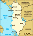
Location: Southeastern Europe, bordering the Adriatic Sea and Ionian Sea, between Greece and Serbia and Montenegro
Geographic coordinates: 41 00 N, 20 00 E
Map references: Europe
Area: Total: 28,748 sq km land: 27,398 sq km water: 1,350 sq km
Area - comparative: Slightly smaller than Maryland
Land boundaries: Total: 720 km border countries: Greece 282 km, Macedonia 151 km, Serbia and Montenegro 287 km
Coastline: 362 km
Maritime claims: Territorial sea: 12 nm continental shelf: 200-m depth or to the depth of exploitation
Climate: Mild temperate; cool, cloudy, wet winters; hot, clear, dry summers; interior is cooler and wetter
Terrain: Mostly mountains and hills; small plains along coast
Elevation extremes: Lowest point: Adriatic Sea 0 m highest point: Maja e Korabit (Golem Korab) 2,764 m
Natural resources: Petroleum, natural gas, coal, bauxite, chromite, copper, iron ore, nickel, salt, timber, hydropower
Land use: Arable land: 21.09% permanent crops: 4.42% other: 74.49% (2001)
Irrigated land: 3,400 sq km (1998 est.)
Natural hazards: Destructive earthquakes; tsunamis occur along southwestern coast; floods; drought
Environment - current issues: Deforestation; soil erosion; water pollution from industrial and domestic effluents
Environment - international agreements: Party to: Biodiversity, Climate Change, Desertification, Endangered Species, Hazardous Wastes, Law of the Sea, Ozone Layer Protection, Wetlands signed, but not ratified: none of the selected agreements
Geography - note: Strategic location along Strait of Otranto (links Adriatic Sea to Ionian Sea and Mediterranean Sea)
Advertisement
The information here has been derived from Public Domain Sources such as the CIA World Factbook. No liability can be taken for any inaccuracies.
Tot: 0.045s; Tpl: 0.014s; cc: 6; qc: 6; dbt: 0.008s; 1; m:domysql w:travelblog (10.17.0.13); sld: 1;
; mem: 1.1mb
 Between 1990 and 1992 Albania ended 46 years of xenophobic Communist rule and established a multiparty democracy. The transition has proven difficult as successive governments have tried to deal with high unemployment, widespread corruption, a dilapi...